
Hamilton County, Ohio facts for kids
Quick facts for kids
Hamilton County
|
|||||
|---|---|---|---|---|---|
|
County
|
|||||

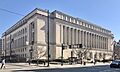
Hamilton County Courthouse
|
|||||
|
|||||

Location within the U.S. state of Ohio
|
|||||
 Ohio's location within the U.S. |
|||||
| Country | |||||
| State | |||||
| Founded | January 2, 1790 | ||||
| Named for | Alexander Hamilton | ||||
| Seat | Cincinnati | ||||
| Largest city | Cincinnati | ||||
| Area | |||||
| • Total | 413 sq mi (1,070 km2) | ||||
| • Land | 406 sq mi (1,050 km2) | ||||
| • Water | 6.7 sq mi (17 km2) 1.6%% | ||||
| Population
(2020)
|
|||||
| • Total | 830,639 | ||||
| • Estimate
(2023)
|
827,058 |
||||
| • Density | 2,011.2/sq mi (776.5/km2) | ||||
| Time zone | UTC−5 (Eastern) | ||||
| • Summer (DST) | UTC−4 (EDT) | ||||
| Congressional districts | 1st, 8th | ||||

.svg)

Hamilton County is located in the southwestern part of the U.S. state of Ohio. It is the third-most populated county in Ohio. In 2020, about 830,639 people lived here. The main city and county seat is Cincinnati. The county is named after Alexander Hamilton, who was the very first Secretary of the Treasury for the United States. Hamilton County is also part of the larger Cincinnati metropolitan area.
Contents
History of Hamilton County
The southern part of Hamilton County was first bought by John Cleves Symmes. The first settlers arrived in 1788 after the American Revolutionary War. They traveled down the Ohio River and started towns like Losantiville (which later became Cincinnati), North Bend, and Columbia.
How Hamilton County Started
Hamilton County was officially created in 1790. This was ordered by Arthur St. Clair, who was the governor of the Northwest Territory at the time. It was the second county formed in the Northwest Territory. Cincinnati was chosen as its main city. People named the county after Alexander Hamilton, a very important person in early American history. He was the first Secretary of the Treasury for the United States.
When it was first created, Hamilton County was much larger. It included about one-eighth of Ohio and even parts of what is now Michigan! Over time, other counties were formed from Hamilton County, making it its current size.
Early Challenges and Growth
Before and after the county was formed, there were many conflicts during the Northwest Indian War. In the 1820s, the United States government made most of the Shawnee and other Native American groups move to lands west of the Mississippi River.
The county grew very quickly in the 1830s and 1840s. Many immigrants from Germany and Ireland moved here. This was especially true after the Great Famine in Ireland and the revolutions in Germany in 1848.
During the American Civil War, a group of Confederate soldiers led by Morgan rode through the northern part of the county in 1863. This event is known as Morgan's Raid.
Later, in 1942, the United States Army built the Sharonville Engineer Depot in northern Hamilton County. This site was used for military purposes for many years. Today, most of it has been redeveloped for businesses.
Geography and Nature
.jpg)
Hamilton County covers about 413 square miles. Most of this is land, with about 6.7 square miles being water.
Neighboring Counties
Hamilton County shares borders with several other counties:
- Franklin County, Indiana (northwest)
- Dearborn County, Indiana (west)
- Butler County (north)
- Warren County (northeast)
- Clermont County (east)
- Campbell County, Kentucky (southeast)
- Kenton County, Kentucky (south)
- Boone County, Kentucky (southwest)
Rivers, Lakes, and Hills

The county has gentle hills formed by the Ohio River valley and its smaller rivers. The Great Miami River, the Little Miami River, and the Mill Creek all flow through this area, creating valleys and hillsides.
There are no natural lakes in Hamilton County. However, there are three large lakes made by people that are part of the Great Parks of Hamilton County.
- Winton Woods Lake is the biggest, covering 188 acres.
- Miami Whitewater Lake covers 85 acres.
- Sharon Lake covers 36 acres.
The lowest point in Ohio is in Hamilton County, in Miami Township. This is where the Ohio River leaves Ohio and flows into Indiana. The elevation here is about 455 feet above sea level.
The highest point in Hamilton County is the Rumpke Sanitary Landfill in Colerain Township. It is about 1,045 feet above sea level.
Main Roads
Many important highways run through Hamilton County, connecting it to other areas. These include:
- Interstate 71
- Interstate 74
- Interstate 75
- Interstate 275
- U.S. Route 50
Population and People
| Population of Hamilton County 1800–2020 | |||||||||||||||||||||||||||||||||||||||||||||||||||||||||||||||||||||||||||||||
|---|---|---|---|---|---|---|---|---|---|---|---|---|---|---|---|---|---|---|---|---|---|---|---|---|---|---|---|---|---|---|---|---|---|---|---|---|---|---|---|---|---|---|---|---|---|---|---|---|---|---|---|---|---|---|---|---|---|---|---|---|---|---|---|---|---|---|---|---|---|---|---|---|---|---|---|---|---|---|---|
|
|
||||||||||||||||||||||||||||||||||||||||||||||||||||||||||||||||||||||||||||||
| U.S. Decennial Census 1790-1960 1900-1990 1990-2000 2010-2020 |
|||||||||||||||||||||||||||||||||||||||||||||||||||||||||||||||||||||||||||||||
Population in 2020
In 2020, Hamilton County had 830,639 people. This means there were about 2,046 people living in each square mile.
- About 63.3% of the people were White.
- About 25.2% were Black or African American.
- About 3.0% were Asian.
- About 4.4% of the population were Hispanic or Latino.
The average age in the county was 37 years old. About 22.6% of the people were under 18 years old.
Population Changes Over Time
Hamilton County's population was highest in 1970. For a while, the population went down a little each decade. This was mainly because people moved out of the county. However, in the last ten years, the population has started to grow again. Many people from Cincinnati and Hamilton County have moved to nearby counties, which has helped the larger Cincinnati area grow.
Education in Hamilton County

Hamilton County offers many choices for education, from elementary school to college.
Schools for Kids (K-12)
There are 23 public school districts that serve students from kindergarten through 12th grade. Some of the larger ones include:
- Cincinnati Public Schools
- Forest Hills Local
- Princeton City
- Sycamore Community
In 2016, Cincinnati Public Schools had about 35,000 students. The county also has a special school for job training called the Great Oaks Institute of Technology and Career Development. Many private schools are also available, including a large system of Catholic schools.
Colleges and Universities

Hamilton County is home to several colleges and universities where students can continue their education after high school. These include:
- University of Cincinnati
- Xavier University
- Cincinnati State Technical and Community College
- Mount St. Joseph University
- Art Academy of Cincinnati
- Hebrew Union College
Transportation
Hamilton County has a good transportation system, making it easy to travel around.
Major Roads
The county is served by several major highways, including:
- Interstate 71
- Interstate 74
- Interstate 75
- Interstate 275
Railroads
Several railroad companies operate in the county, including CSX Transportation and Norfolk Southern. Amtrak also provides passenger train services.
Fun and Recreation

Hamilton County offers many ways to have fun and enjoy the outdoors.
The Public Library of Cincinnati and Hamilton County system has a main library and 41 branch libraries. This means there are many places to find books and learn new things.
The Great Parks of Hamilton County manages many parks and nature preserves. Three of the biggest parks are Miami Whitewater Forest, Winton Woods, and Sharon Woods. These parks offer trails, lakes, and places to explore nature.
The Hamilton County Fair is the oldest county fair in Ohio. It's a fun event with rides, food, and exhibits.
Communities in Hamilton County

Hamilton County is made up of many different cities, villages, and townships.
Cities
- Blue Ash
- Cincinnati (the county seat)
- Forest Park
- Harrison
- Loveland (part)
- Madeira
- Montgomery
- Norwood
- Sharonville (mostly)
- Wyoming
Villages
Townships
- Anderson
- Colerain
- Columbia
- Delhi
- Green
- Miami
- Springfield
- Sycamore
- Symmes
- Whitewater
Other Communities
Hamilton County also has many smaller communities, including census-designated places and unincorporated areas. Some of these are:
Cincinnati itself has many unique neighborhoods, such as:
- Downtown
- Hyde Park
- Over-the-Rhine
- Walnut Hills
- Westwood
Images for kids
-
Hamilton County Courthouse
See also
 In Spanish: Condado de Hamilton (Ohio) para niños
