St. Bernard, Ohio facts for kids
Quick facts for kids
St. Bernard, Ohio
|
|||
|---|---|---|---|

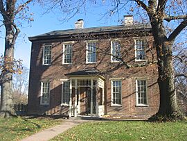
Nurre-Royston House, built 1859
|
|||
|
|||

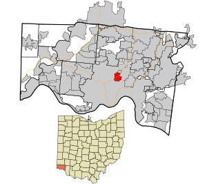
Location in Hamilton County and the state of Ohio
|
|||

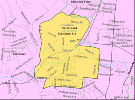
Detailed map of St. Bernard
|
|||
| Country | United States | ||
| State | Ohio | ||
| County | Hamilton | ||
| Area | |||
| • Total | 1.54 sq mi (4.00 km2) | ||
| • Land | 1.53 sq mi (3.97 km2) | ||
| • Water | 0.01 sq mi (0.02 km2) | ||
| Elevation | 541 ft (165 m) | ||
| Population
(2020)
|
|||
| • Total | 4,070 | ||
| • Density | 2,651.47/sq mi (1,023.97/km2) | ||
| Time zone | UTC-5 (Eastern (EST)) | ||
| • Summer (DST) | UTC-4 (EDT) | ||
| FIPS code | 39-69470 | ||
| GNIS feature ID | 1086226 | ||
St. Bernard is a small village located in Hamilton County, Ohio, United States. It is like a small town completely surrounded by the larger city of Cincinnati. In 2020, about 4,070 people lived there.
Contents
Village History
St. Bernard was first planned in 1851. It was built where Main Street (now Vine Street, Cincinnati), the Miami and Erie Canal, and the Cincinnati, Hamilton and Dayton Railway all met. Many of the first people who settled here were from Germany.
St. Bernard officially became a village in 1878.
Where is St. Bernard?
St. Bernard is a unique place because it is an enclave. This means it is a separate town completely surrounded by the city of Cincinnati. Other nearby towns like Norwood and Elmwood Place are also enclaves.
The village covers a total area of about 1.56 square miles (4.04 square kilometers). Most of this area is land, with only a very small part being water.
People of St. Bernard
The population of St. Bernard has changed over the years. Here's a quick look at how many people have lived there:
| Historical population | |||
|---|---|---|---|
| Census | Pop. | %± | |
| 1880 | 1,022 | — | |
| 1890 | 1,770 | 73.2% | |
| 1900 | 3,384 | 91.2% | |
| 1910 | 5,002 | 47.8% | |
| 1920 | 6,312 | 26.2% | |
| 1930 | 7,487 | 18.6% | |
| 1940 | 7,387 | −1.3% | |
| 1950 | 7,066 | −4.3% | |
| 1960 | 6,778 | −4.1% | |
| 1970 | 6,131 | −9.5% | |
| 1980 | 5,396 | −12.0% | |
| 1990 | 5,344 | −1.0% | |
| 2000 | 4,924 | −7.9% | |
| 2010 | 4,368 | −11.3% | |
| 2020 | 4,070 | −6.8% | |
| Sources: | |||
Population in 2020
In 2020, there were 4,070 people living in St. Bernard. The village had about 2,651 people per square mile. Most residents were White (70.6%), and about 20.2% were Black or African American. People from two or more races made up 6.6% of the population.
The average age of people in St. Bernard was 46.7 years old. About 15.8% of the population was under 18 years old. About 15.5% of residents were 65 years or older.
The average household in St. Bernard had 2.31 people. The average family had 3.05 people. Many households were made up of individuals living alone.
Population in 2010
In 2010, the village had 4,368 people. The population density was about 2,818 people per square mile. Most people were White (80.0%), and 15.7% were African American.
The median age in 2010 was 38.2 years. About 23.6% of residents were under 18. About 13% were 65 or older.
Schools in St. Bernard
St. Bernard shares a public school district with the nearby Village of Elmwood Place. This district is called St. Bernard-Elmwood Place Village Schools. It is separate from the larger Cincinnati Public Schools.
The district has one building that serves both elementary and high school students. St. Bernard also has two private schools: St. Clement Elementary and Roger Bacon High School.
The village also has a branch of the Public Library of Cincinnati and Hamilton County.
See also

- In Spanish: St. Bernard (Ohio) para niños
 | Emma Amos |
 | Edward Mitchell Bannister |
 | Larry D. Alexander |
 | Ernie Barnes |


