Miami and Erie Canal facts for kids
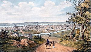
The Miami and Erie Canal was a 274-mile-long waterway in Ohio. It connected the Ohio River in Cincinnati to Lake Erie in Toledo, Ohio. This amazing canal created a water route for boats to travel across Ohio.
Building the canal started in 1825 and finished in 1845. It cost the state government over $8 million. At its busiest, the canal had 19 aqueducts (bridges for water), three guard locks, and 103 canal locks. It also had many smaller canals and man-made lakes to supply water.
The canal climbed 395 feet above Lake Erie and 513 feet above the Ohio River. This highest point was called the Loramie Summit. Boats up to 80 feet long were pulled by mules, horses, or oxen. These animals walked on a special path called a towpath along the canal bank. Boats moved at about four to five miles per hour.
By the 1850s, railroads started to appear. They offered faster ways to move people and goods. Because of this, the canal's use for business slowly decreased. In 1913, a huge flood in Ohio badly damaged the canal. After that, it was no longer used for business. Today, only small parts of the canal, its towpath, and some locks still exist.
Contents
Why Ohio Needed Canals
When Ohio became a state in 1803, traveling and moving goods was very hard. Most people used rivers and Lake Erie because roads were often in poor condition. Also, the Appalachian Mountains separated Ohio from the East Coast. This made it difficult and expensive to get goods from the Atlantic Coast or Europe.
Ohio farmers and business owners also struggled to sell their products outside the state. Some tried shipping goods down the Ohio River to New Orleans. But this journey was long and costly, even after steamboats became common.
High shipping costs slowed down trade and population growth in Ohio. This was especially true for areas far from natural waterways like Lake Erie or the Ohio River.
Early Ideas for Canals
To solve these problems, many people thought a national canal system was a good idea. Even important figures like George Washington supported connecting the country's waterways. In 1807, Ohio Senator Thomas Worthington asked for money to build roads and canals in Ohio. However, he didn't have much success.
At that time, many leaders believed that states, not the national government, should build such projects. The United States Congress tried to pass laws for national canals in 1817, 1822, and 1830. But each time, the president in office said no.
So, the job of building canals fell to the states. New York's Erie Canal was a big success when it finished in 1825. Ohio's lawmakers had worked for 20 years to approve a canal. Finally, on February 4, 1825, a law was passed to build Ohio's canal system.
The state mostly paid for the canal by selling land near where the canals would be dug. Ohio planned and built two main canals. The Miami and Erie Canal connected Cincinnati to Toledo. The Ohio and Erie Canal connected Cleveland to Portsmouth, Ohio. This system gave Ohio new travel routes that reached all the way to New York City. Merchants could ship goods through Lake Erie, the Erie Canal, and the Hudson River.
Building the Canal System
Ohio's land is not completely flat. So, a system of canal locks was needed. These locks worked like a staircase, allowing boats to move up and down different elevations.
To keep the canal full of water, workers built man-made lakes. These included Grand Lake St. Marys and Lake Loramie. Several smaller feeder canals also brought water to the main canal. Indian Lake was made much larger to provide a steady water supply for the Sidney feeder canal.
Branch Canals and Measurements
Smaller branch canals were built to extend from the main canal. The Warren County Canal was one such branch. It ran from the Miami and Erie Canal at Middletown to Lebanon. This branch opened in 1840 but was used for less than 15 years. Another short branch was the Sidney or Port Jefferson feeder canal. It went up the Miami Valley from Lockington through Sidney.
Here are some typical measurements for the canal:
- The water was about 4 feet deep.
- The canal was about 40 feet wide at the water level.
- The towpath, where animals walked, was about 10 feet wide.
- The canal could hold boats up to 90 feet long and 14 feet wide.
Why the Canal Declined
The Miami and Erie Canal never made as much money as the state hoped. Just a few years after it was finished, it had to compete with railroads. Trains were much faster and could carry more passengers and goods.
Several things limited the canal's success. Ohio had fewer people and less business activity compared to New York when its Erie Canal was built. Also, New York had one main canal that was perfect for trade. Ohio had two canals, which spread out the traffic too much. Finally, building and keeping up the canals was very expensive. The Erie Canal was 363 miles long with a 700-foot elevation change. Ohio's canals combined were 557 miles long with a 2,096-foot elevation change. This meant Ohio's canals had less trade and fewer passengers, but cost more to operate over a longer distance.
The canal was finished just before most railroads were built in Ohio. It had to compete directly with trains for its entire operation. Canals would freeze in winter, and boats were slow. This made them less useful than railroads, especially for food that spoiled quickly or for people traveling. Even though canal services were often cheaper for large items like grain, the canal mostly stopped operating by 1906.
The End of the Canal
The terrible Great Dayton Flood of 1913 caused huge damage. Flood control projects built afterward destroyed much of the canal's structures in the southern part of the route. The canal was then permanently closed. What wasn't destroyed was no longer cared for. Over time, many remaining locks and canal sections were ruined or filled in.
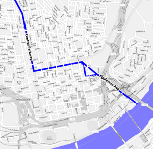
Much of the original towpath was later used for the Cincinnati and Lake Erie Railroad. This electric streetcar operated until 1938. Part of this path became the Wright-Lockland Highway, which is now part of Interstate 75. From 1920 to 1925, $6 million was spent to build a subway in downtown Cincinnati using the canal bed. However, money ran out before the Cincinnati Subway could be finished. The surface was later paved to create Central Parkway.
In central and northern Ohio, large parts of the canal were filled in to build parts of I-75, U.S. Route 24, and State Route 25. Some smaller sections of the towpath have been turned into bike trails for fun and local travel.
Canal's Lasting Impact
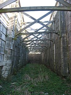
Even though cities have grown and covered most of the canal, some locks and parts of the waterway still exist. One of the original locks (#17) is at the Carillon Historical Park in Dayton. An untouched but complete lock (#15) is near Main Street in Tipp City. Remains of the Excello lock are in the Butler County Excello Locks Park.
The large west end of the Old Nine-mile Aqueduct is still visible near the Taylorsville Dam. This marks the end of a fairly complete canal section that stretches at least 5 miles north to Tipp City. This section includes a concrete weir and a ruined lock (#16, "Picayune").
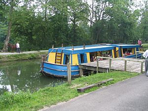
In St. Bernard, Ohio, a drained section of the canal is visible in Ludlow Park. The canal still has water and can be used by canoes or kayaks between Delphos and St. Marys, Ohio. South of St. Mary's, it's mostly a shallow ditch with some ruined locks. Along State Route 66, parts of the original canal can be seen in Delphos, at the Miami and Erie Canal Deep Cut in Spencerville, and in towns like New Bremen and Piqua. The Deep Cut was named a U.S. National Historic Landmark in 1964. The Piqua Historical Area has a replica canal boat and other related items.
Anthony Wayne Trail in Toledo was built on the canal's path. Many parts of the canal can still be found along this road.
Today, the area along the canal corridor is still a busy manufacturing region. Interstate 75 and railroads are now the main ways people and goods travel. A historical reenactment of the Miami-Erie canal days happens at Providence Metropark near Grand Rapids. Actors dress up and pretend it's 1876. Two mules pull a canal boat called The Volunteer. Workers steer the boat and tell stories to the passengers. Providence Metroparks uses original lock 44, which is the only working lock in Ohio. The northern part of the towpath is now used as a hiking trail.
Towns Along the Canal
Here is a list of towns and cities along the Miami and Erie Canal, from north to south:
- Toledo, Ohio
- Maumee, Ohio
- Waterville, Ohio
- Providence, Ohio (a former city)
- Napoleon, Ohio
- Florida, Ohio
- Defiance, Ohio (where the canal turns south)
- Junction, Ohio
- Melrose, Ohio
- Ottoville, Ohio
- Delphos, Ohio
- Spencerville, Ohio
- Kossuth, Ohio
- St. Marys, Ohio
- New Bremen, Ohio
- Minster, Ohio
- Fort Loramie, Ohio
- Port Jefferson, Ohio (north end of the Sidney Feeder)
- Sidney, Ohio (middle of the feeder)
- Lockington, Ohio (south end of the Sidney Feeder)
- Piqua, Ohio
- Troy, Ohio
- Tipp City, Ohio
- Huber Heights, Ohio
- Dayton, Ohio
- Moraine, Ohio
- Alexandersville, Ohio
- West Carrollton, Ohio
- Miamisburg, Ohio
- Franklin, Ohio
- Middletown, Ohio
- Hamilton, Ohio
- West Chester, Ohio
- Sharonville, Ohio
- Evendale, Ohio
- Lockland, Ohio (site of the first set of locks)
- Elmwood Place, Ohio
- St. Bernard, Ohio
- Cincinnati, Ohio
 | Bessie Coleman |
 | Spann Watson |
 | Jill E. Brown |
 | Sherman W. White |


