
Grand Rapids, Ohio facts for kids
Quick facts for kids
Grand Rapids, Ohio
|
|
|---|---|
|
Village
|
|

Businesses in downtown Grand Rapids.
|
|

Location of Grand Rapids, Ohio
|
|

Location of Grand Rapids in Wood County
|
|
| Country | United States |
| State | Ohio |
| County | Wood |
| Township | Grand Rapids |
| Area | |
| • Total | 0.97 sq mi (2.51 km2) |
| • Land | 0.88 sq mi (2.28 km2) |
| • Water | 0.09 sq mi (0.23 km2) |
| Elevation | 663 ft (202 m) |
| Population
(2020)
|
|
| • Total | 925 |
| • Estimate
(2023)
|
928 |
| • Density | 1,048.75/sq mi (404.88/km2) |
| Time zone | UTC-5 (Eastern (EST)) |
| • Summer (DST) | UTC-4 (EDT) |
| ZIP code |
43522
|
| Area code(s) | 419 |
| FIPS code | 39-31206 |
| GNIS feature ID | 2398187 |
Grand Rapids is a small village in Ohio, United States. It is located in Wood County, right along the Maumee River. In 2020, about 925 people lived here. Grand Rapids is served by a branch of the Weston Public Library.
Contents
History of Grand Rapids
Grand Rapids was first called Gilead. It was planned out in 1833. In the 1840s, Ohio needed more water for its canals. So, in 1845, a large dam was built across the Maumee River at Gilead.
This new dam caused problems for a local mill. The mill used water power, and the dam restricted it. The people of Gilead were very upset. They even destroyed the dam!
After the dam was gone, a special side canal was built. This canal connected Gilead to the main canal. This helped the village's economy grow. In 1855, Gilead officially became a village and changed its name to Grand Rapids.
A post office named Gilead opened in 1837. Its name was changed to Grand Rapids in 1868. The village was officially incorporated in 1885. In February 1959, a big ice jam caused a major flood. This flood damaged many homes and forced 130 people to leave.
Geography of Grand Rapids
-
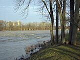
The Maumee River as seen from Grand Rapids
-
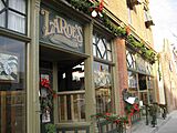
LaRoe's Restaurant, one of the oldest businesses in Grand Rapids


Grand Rapids is located in Ohio, along the Maumee River. The village covers about 0.97 square miles (2.51 square kilometers). Most of this area is land, about 0.88 square miles (2.28 square kilometers). The rest, about 0.09 square miles (0.23 square kilometers), is water.
Population Facts
| Historical population | |||
|---|---|---|---|
| Census | Pop. | %± | |
| 1880 | 332 | — | |
| 1890 | 572 | 72.3% | |
| 1900 | 549 | −4.0% | |
| 1910 | 574 | 4.6% | |
| 1920 | 517 | −9.9% | |
| 1930 | 589 | 13.9% | |
| 1940 | 614 | 4.2% | |
| 1950 | 657 | 7.0% | |
| 1960 | 670 | 2.0% | |
| 1970 | 976 | 45.7% | |
| 1980 | 962 | −1.4% | |
| 1990 | 955 | −0.7% | |
| 2000 | 1,002 | 4.9% | |
| 2010 | 965 | −3.7% | |
| 2020 | 925 | −4.1% | |
| 2023 (est.) | 928 | −3.8% | |
| U.S. Decennial Census | |||

Who Lives in Grand Rapids?
In 2010, there were 965 people living in Grand Rapids. The population density was about 1096.6 people per square mile. This means a lot of people live in a small area. There were 429 homes in the village.
Most people in Grand Rapids are White, making up 96.5% of the population. A small number of people are African American (0.5%), Native American (0.2%), or Asian (0.1%). About 3.9% of the population identified as Hispanic or Latino.
The average age in the village was about 38.9 years old. About 25.3% of residents were under 18 years old. About 15.6% were 65 years or older. The population was almost evenly split between males (47.9%) and females (52.1%).
Famous People from Grand Rapids
- Edward Byers – He received the Medal of Honor, a very brave award.
- Dominick Labino – He was a talented glass researcher and artist.
See also
 In Spanish: Grand Rapids (Ohio) para niños
