Wood County, Ohio facts for kids
Quick facts for kids
Wood County
|
|||
|---|---|---|---|
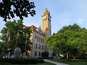
Wood County Courthouse and Jail in Bowling Green, Ohio
|
|||
|
|||
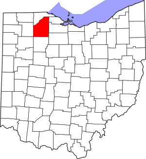
Location within the U.S. state of Ohio
|
|||
 Ohio's location within the U.S. |
|||
| Country | |||
| State | |||
| Founded | April 1, 1820 | ||
| Named for | Captain Eleazer D. Wood | ||
| Seat | Bowling Green | ||
| Largest city | Bowling Green | ||
| Area | |||
| • Total | 620 sq mi (1,600 km2) | ||
| • Land | 617 sq mi (1,600 km2) | ||
| • Water | 3.3 sq mi (9 km2) 0.5%% | ||
| Population
(2020)
|
|||
| • Total | 132,248 |
||
| • Density | 210/sq mi (80/km2) | ||
| Time zone | UTC−5 (Eastern) | ||
| • Summer (DST) | UTC−4 (EDT) | ||
| Congressional districts | 5th, 9th | ||
Wood County is a county located in the state of Ohio in the United States. In 2020, about 132,248 people lived here. The main city and county seat is Bowling Green.
The county is named after Captain Eleazer D. Wood. He was an engineer for General William Henry Harrison's army during the War of 1812. Captain Wood helped build Fort Meigs. Wood County is also part of the larger Toledo area. Its northwest border follows the Maumee River, which flows into Maumee Bay on Lake Erie.
Contents
History of Wood County
Wood County was officially created on February 12, 1820. This happened after a special agreement and land purchase from the local Native American tribes.
The first county seat was Perrysburg. It stayed the main city until 1870. Then, the county seat was moved to Bowling Green.
In 1920, Wood County started its first health department. This helped keep people in the county healthy.
Geography of Wood County
Wood County covers a total area of about 620 square miles. Most of this area, about 617 square miles, is land. The rest, about 3.3 square miles, is water.
Counties Nearby
Wood County shares borders with several other counties:
- Lucas County (north)
- Ottawa County (northeast)
- Sandusky County (east)
- Seneca County (southeast)
- Hancock County (south)
- Putnam County (southwest)
- Henry County (west)
People in Wood County
| Historical population | |||
|---|---|---|---|
| Census | Pop. | %± | |
| 1820 | 733 | — | |
| 1830 | 1,102 | 50.3% | |
| 1840 | 5,357 | 386.1% | |
| 1850 | 9,157 | 70.9% | |
| 1860 | 17,886 | 95.3% | |
| 1870 | 24,596 | 37.5% | |
| 1880 | 34,022 | 38.3% | |
| 1890 | 44,392 | 30.5% | |
| 1900 | 51,555 | 16.1% | |
| 1910 | 46,330 | −10.1% | |
| 1920 | 44,892 | −3.1% | |
| 1930 | 50,320 | 12.1% | |
| 1940 | 51,796 | 2.9% | |
| 1950 | 59,605 | 15.1% | |
| 1960 | 72,596 | 21.8% | |
| 1970 | 89,722 | 23.6% | |
| 1980 | 107,372 | 19.7% | |
| 1990 | 113,269 | 5.5% | |
| 2000 | 121,065 | 6.9% | |
| 2010 | 125,488 | 3.7% | |
| 2020 | 132,248 | 5.4% | |
| U.S. Decennial Census 1790-1960 1900-1990 1990-2000 2020 |
|||
What the 2010 Census Showed
In 2010, there were 125,488 people living in Wood County. There were 49,043 households, which are groups of people living together. The population density was about 203 people per square mile.
Most people in the county were white (92.8%). Other groups included Black or African American (2.4%), Asian (1.5%), and American Indian (0.2%). About 4.5% of the population was of Hispanic or Latino background.
Many families had children under 18 living with them (29.5%). The average household had 2.43 people. The average age of people in the county was 35.3 years old.
Libraries in Wood County
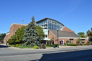
Wood County has many libraries that serve its communities. The Wood County District Public Library is a big one. It serves Bowling Green and other parts of the county. It has a main library in Bowling Green and a branch in Walbridge.
In 2019, this library loaned out over 783,000 items. It also held 1,473 programs for people to enjoy. The library had over 158,000 print books, 21,000 videos, and 12,000 audio recordings.
Other libraries in the county include:
- North Baltimore Public Library
- Pemberville Public Library, with branches in Luckey and Stony Ridge
- Rossford Public Library
- Way Public Library in Perrysburg
- Wayne Public Library
- Weston Public Library, with a branch in Grand Rapids
All these libraries, along with the Kaubisch Memorial Public Library in Fostoria, share a special system called Woodlink. This means they all use one catalog to find books and other items.
Communities in Wood County
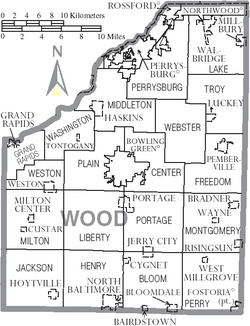
Cities in Wood County
- Bowling Green (county seat)
- Fostoria
- Northwood
- Perrysburg
- Rossford
Villages in Wood County
Townships in Wood County
- Bloom
- Center
- Freedom
- Grand Rapids
- Henry
- Jackson
- Lake
- Liberty
- Middleton
- Milton
- Montgomery
- Perry
- Perrysburg
- Plain
- Portage
- Troy
- Washington
- Webster
- Weston
Census-Designated Places
These are areas that are like villages but are not officially incorporated:
Unincorporated Communities
These are smaller communities that are not part of a city or village:
- Bates
- Bays
- Blake
- Bloom Center
- Christy
- Cloverdale
- Denver
- Digby
- Dowling
- Ducat
- Dunbridge
- Eagleville
- Five Points
- Galatea
- Hammansburg
- Hatton
- Hull Prairie
- Latcha
- Lemoyne
- Lime City
- Mermill
- Moline
- Mungen
- New Rochester
- Otsego
- Perry Center
- Roachton
- Scotch Ridge
- Six Points
- Stanley
- Sugar Ridge
- Trombley
- Wingston
- Woodside
Economy of Wood County
Wood County has many important employers that provide jobs for its residents. Here are some of the largest ones from 2019:
| # | Employer | # of employees |
|---|---|---|
| 1 | Bowling Green State University | 3,300 |
| 2 | Magna | 2,200 |
| 3 | First Solar, Inc | 1,200 |
| 4 | Owens Community College | 1,000 |
| 5 | Waltrust/Walgreen Company | 1,000 |
| 6 | Wood County Hospital | 875 |
| 7 | Wood County | 842 |
| 8 | FedEx Ground | 800 |
| 9 | Fiat Chrysler Automobiles | 800 |
| 10 | Home Depot | 750 |
Community Resources
The Cocoon
The Cocoon is an important organization in Wood County. It helps people and families who are facing difficult situations. They provide safe housing, advice, and support to help people find jobs and new homes.
The idea for The Cocoon started around 2000. It was a response to a need for more help for families in the area. The Cocoon officially began helping people in June 2005. By 2012, all its services were offered from a safe, private location.
Like many groups, The Cocoon faced money challenges, especially during the COVID-19 Pandemic. Some of its funding was reduced. In 2021, the county received special funds from the American Rescue Plan Act. The Cocoon asked for some of this money, and the county leaders approved it in March 2022. This helped The Cocoon continue its important work.
See also
 In Spanish: Condado de Wood (Ohio) para niños
 | Sharif Bey |
 | Hale Woodruff |
 | Richmond Barthé |
 | Purvis Young |


