
Millbury, Ohio facts for kids
Quick facts for kids
Millbury, Ohio
|
|
|---|---|
|
Village
|
|

Post office
|
|

Location of Millbury, Ohio
|
|

Location of Millbury in Wood County
|
|
| Country | United States |
| State | Ohio |
| County | Wood |
| Township | Lake |
| Area | |
| • Total | 1.00 sq mi (2.58 km2) |
| • Land | 1.00 sq mi (2.58 km2) |
| • Water | 0.00 sq mi (0.00 km2) |
| Elevation | 614 ft (187 m) |
| Population
(2020)
|
|
| • Total | 1,193 |
| • Density | 1,197.79/sq mi (462.41/km2) |
| Time zone | UTC-5 (Eastern (EST)) |
| • Summer (DST) | UTC-4 (EDT) |
| ZIP code |
43447
|
| Area code(s) | 419 |
| FIPS code | 39-50260 |
| GNIS feature ID | 2399352 |
Millbury is a small village located in Wood County, Ohio, in the United States. In 2020, about 1,193 people lived there.
Contents
Millbury's Past: A Look at History
Before it was called Millbury, this area was known as Clay Junction. The village was officially planned in 1864. It was named after another town, Millbury, Massachusetts. A post office opened here even earlier, in 1857. Millbury officially became a village in 1874.
The 2010 Tornado: A Powerful Storm
On June 5, 2010, a very strong tornado hit Millbury. It was an EF4 tornado, which means it was extremely powerful. The storm caused a lot of damage, destroying at least 50 homes. Sadly, seven people lost their lives.
The tornado also destroyed important buildings. These included the Lake Township Administration Building and Police Department. Lake High School was also destroyed. After the tornado, Governor Ted Strickland declared a state of emergency. This helped the area get special assistance.
Millbury's Location and Size
Millbury is a small village. It covers an area of about 1.00 square mile (2.58 square kilometers). All of this area is land, with no large bodies of water inside the village limits.
Who Lives in Millbury: Population Facts
| Historical population | |||
|---|---|---|---|
| Census | Pop. | %± | |
| 1880 | 483 | — | |
| 1890 | 546 | 13.0% | |
| 1900 | 284 | −48.0% | |
| 1910 | 276 | −2.8% | |
| 1920 | 232 | −15.9% | |
| 1930 | 403 | 73.7% | |
| 1940 | 428 | 6.2% | |
| 1950 | 482 | 12.6% | |
| 1960 | 730 | 51.5% | |
| 1970 | 771 | 5.6% | |
| 1980 | 955 | 23.9% | |
| 1990 | 1,081 | 13.2% | |
| 2000 | 1,161 | 7.4% | |
| 2010 | 1,200 | 3.4% | |
| 2020 | 1,193 | −0.6% | |
| U.S. Decennial Census | |||
Millbury's Population in 2010
In 2010, about 1,200 people lived in Millbury. There were 468 households, which are groups of people living together. About 352 of these were families. The village had about 1,200 people per square mile.
Most of the people in Millbury were White (96.7%). A smaller number were African American (0.7%) or Asian (0.7%). Some people were from other races (1.1%) or from two or more races (0.9%). About 4.8% of the population identified as Hispanic or Latino.
Households and Families
About 33.1% of households had children under 18 living with them. Most households (59.8%) were married couples living together. About 10.7% had a female head of household without a husband. About 4.7% had a male head of household without a wife.
About 24.8% of households were not families. This means they were individuals living alone or roommates. About 21.2% of all households were just one person. And 8.3% of households had someone aged 65 or older living alone.
The average household had 2.56 people. The average family had 2.97 people. The average age of people in Millbury was 40.7 years old. About 25.1% of residents were under 18. About 12.3% were 65 or older. The population was almost evenly split between males (48.3%) and females (51.8%).
Images for kids
-
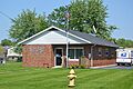
The Millbury Post Office
-
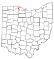
Map showing Millbury in Ohio
-
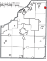
Map showing Millbury in Wood County
See also
 In Spanish: Millbury (Ohio) para niños
