
Millbury, Massachusetts facts for kids
Quick facts for kids
Millbury, Massachusetts
|
||
|---|---|---|

View of Millbury in circa 1905.
|
||
|
||

Location in Worcester County and the state of Massachusetts.
|
||
| Country | United States | |
| State | Massachusetts | |
| County | Worcester | |
| Settled | 1716 | |
| Incorporated | 1813 | |
| Government | ||
| • Type | Open town meeting | |
| Area | ||
| • Total | 16.3 sq mi (42.1 km2) | |
| • Land | 15.7 sq mi (40.7 km2) | |
| • Water | 0.5 sq mi (1.3 km2) | |
| Elevation | 417 ft (127 m) | |
| Population
(2020)
|
||
| • Total | 13,831 | |
| • Density | 848.5/sq mi (328.5/km2) | |
| Time zone | UTC−5 (Eastern) | |
| • Summer (DST) | UTC−4 (Eastern) | |
| ZIP Code |
01527
|
|
| Area code(s) | 508/774 | |
| FIPS code | 25-41340 | |
| GNIS feature ID | 0618373 | |

Millbury, officially called the Town of Millbury, is a town in Worcester County, Massachusetts, USA. It's located within an area known as the Blackstone Valley. In 2020, about 13,831 people lived in Millbury.
Contents
Millbury's Story
Millbury was first settled by Europeans in 1716. It was originally known as the North Parish of Sutton. People found it hard to travel across Sutton for meetings. So, the North Parish asked the state government to let them become their own town.
Becoming a Town
On June 11, 1813, North Parish officially became Millbury. This happened through an act of incorporation. The town got its name because it had many mills. The Blackstone River flows through Millbury. During the Industrial Revolution, this river provided water power for many textile mills and factories. A famous inventor named William Crompton worked in Millbury during this time.
Early Industries
Millbury's industrial history began in the early 1700s. In 1735, John Singletary started a mill on Singletary Brook. This brook flows from Singletary Lake. Around 1753, Singletary built the S & D Spinning Mill. This mill is still working today, making it one of the oldest continuously operated mills in the United States. You can even see this mill on the Town Seal. It also makes the inner parts of Rawlings baseballs used in Major League Baseball.
Later, in the late 1700s and early 1800s, two brothers, Asa Waters and Elijah, bought land by the Blackstone River. They learned how to make firearms from their father. They built mills that made things like guns, scythes (tools for cutting grass), and equipment for sawmills. In 1808, they built an armory (a place to store weapons). This armory did well until it closed in 1841. It reopened in 1861 when the American Civil War began. Asa Waters used his wealth to build the beautiful Asa Waters Mansion in 1826. It was designed by a local architect named Asher Benjamin and finished six years later.
Famous Visitors and Discoveries
Louise Taft, the mother of United States President William Howard Taft, lived in Millbury for many years. President Taft spent many summer vacations in Millbury when he was young. He even visited his aunt, Delia C. Torrey, during his presidency to celebrate Millbury's 100th birthday. The Torrey House, where President Taft stayed, is now called the Taft House.
In 1824, a special mineral called Vermiculite was first discovered in Millbury.
Recent History
In 1944, the Worcester Flood Diversion Channel was built in Millbury. This was part of the Flood Control Act of 1944 to help prevent floods.
In the early 1970s, Millbury had several big fires. The town hall burned down, and then the Union School. A propane plant near Route 146 also exploded. This caused a lot of damage and was reported in news all over the country.
In 2004, Millbury was recognized as a Preserve America community. This means it's a place that works to protect its history.
Millbury celebrated its 200th birthday in 2013. A local art company, Vaillancourt Folk Art, designed special chalkware for the celebration. Later that year, there was a plan to build a casino in Millbury. However, the company stopped the plan because most people in town were against it.
Where is Millbury?
According to the United States Census Bureau, Millbury covers about 16.3 square miles (42.1 square kilometers). Most of this area is land, about 15.7 square miles (40.7 square kilometers). The rest, about 0.5 square miles (1.3 square kilometers), is water. The town is part of the Blackstone Valley, and the Blackstone River flows through it.
Historic Places to See
Millbury has three places listed on the National Register of Historic Places. These are important historical sites:
-
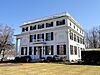
Asa Waters Mansion (added in 1978)
-

First Presbyterian Society Meeting House (added in 2010)
-
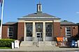
United States Post Office–Millbury Main (added in 1987)


How Many People Live Here?
| Historical population | ||
|---|---|---|
| Year | Pop. | ±% |
| 1850 | 3,081 | — |
| 1860 | 3,296 | +7.0% |
| 1870 | 4,397 | +33.4% |
| 1880 | 4,741 | +7.8% |
| 1890 | 4,428 | −6.6% |
| 1900 | 4,460 | +0.7% |
| 1910 | 4,740 | +6.3% |
| 1920 | 5,653 | +19.3% |
| 1930 | 6,957 | +23.1% |
| 1940 | 6,983 | +0.4% |
| 1950 | 8,347 | +19.5% |
| 1960 | 9,623 | +15.3% |
| 1970 | 11,987 | +24.6% |
| 1980 | 11,808 | −1.5% |
| 1990 | 12,228 | +3.6% |
| 2000 | 12,784 | +4.5% |
| 2010 | 13,261 | +3.7% |
| 2020 | 13,831 | +4.3% |
| 2023* | 14,002 | +1.2% |
| * = population estimate. Source: United States Census records and Population Estimates Program data. |
||
As of the census in 2020, there were 13,831 people living in Millbury. There were 4,927 households, which are groups of people living together. The average household had about 2.53 people.
Most people in Millbury are White (about 97%). There are also smaller groups of African American, Native American, and Asian residents. About 1% of the population is Hispanic or Latino.
The median age in Millbury was 39 years old. This means half the people were younger than 39 and half were older.
Learning in Millbury

In 1826, the first formal lyceum school was started by Josiah Holbrook in Millbury. A lyceum was a place for public lectures and discussions.
Millbury has public schools managed by the Millbury Public Schools district. About 2,000 students attend three schools:
- Elmwood Street School (for Pre-Kindergarten to 2nd grade)
- Raymond E. Shaw Elementary School (for 3rd to 6th grade)
- Millbury Memorial Junior/Senior High School (for 7th to 12th grade)
The Millbury Public Library opened in 1864. It's a great place for everyone to read and learn.
Notable People from Millbury

Many interesting people have connections to Millbury:
- Ron Darling – A professional Major League Baseball player.
- Wilton S. Farnsworth – A journalist who wrote for newspapers.
- Nick Fatool – A talented musician.
- Abby Kelley – An important abolitionist who worked to end slavery.
- Francis March – A very smart person who knew a lot about many subjects and languages.
- Michael O. Moore – A member of the Massachusetts Senate, which is part of the state government.
- Louise Taft – The mother of United States President William Howard Taft.
- Asa Waters – A successful industrialist who built many mills.
See also
 In Spanish: Millbury (Massachusetts) para niños
