
Blackstone River facts for kids
Quick facts for kids Blackstone River |
|
|---|---|

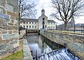
The Blackstone River in Blackstone, Massachusetts, just short of the Rhode Island border.
|
|
 |
|
| Country | United States |
| State | Massachusetts, Rhode Island |
| Region | New England |
| Physical characteristics | |
| Main source | Worcester, MA |
| River mouth | Seekonk River, at Pawtucket Falls in Pawtucket, Rhode Island 41°52′38″N 71°22′56″W / 41.8771°N 71.3822°W |
| Length | 48 mi (77 km) |
| Basin features | |
| Basin size | 540 sq mi (1,400 km2) |
The Blackstone River is a river in the U.S. states of Massachusetts and Rhode Island. It flows for about 48 miles (80 km) and collects water from an area of about 540 square miles (1,400 km2). This river has a long history, especially with factories and industry. Because of this, it has faced a lot of pollution. In 1990, the United States Environmental Protection Agency even called it "the most polluted river in the country" due to harmful stuff in its mud. However, many people are working hard to clean it up!
Contents
What is the History of the Blackstone River?
Who was William Blackstone?
The river is named after William Blackstone. He was one of the first European settlers in the area. He arrived in Massachusetts in 1623. Later, in 1635, he moved to Rhode Island. He built his home right on the river, in what is now Cumberland, Rhode Island.
What was the river's original name?
The Native Americans who lived here first called the river "Kittacuck." This name meant "the great tidal river." Long ago, the Kittacuck, or Blackstone, was full of fish like salmon and lamprey.
How did the river become important for industry?

In 1790, something very important happened. Samuel Slater opened the first successful water-powered cotton mill in America. This mill, called Slater Mill, was in Pawtucket, Rhode Island. It used the power of the Blackstone River's flowing water.
Many other mills and factories soon appeared along the river. This made the Blackstone River a very important part of American industry. But all this industry also caused a lot of pollution. By the end of the 1900s, the river was a major source of pollution for Narragansett Bay.
Has the river ever flooded badly?
Yes, in August 1955, the Blackstone River had terrible floods. These floods caused a lot of damage in Woonsocket, Rhode Island. Normally, the river is about 70 feet (21 m) wide there. But during the flood, it swelled to over 1 mile (1.6 km) wide!
The flooding happened because of two big storms. First, Hurricane Connie brought heavy rain. A week later, Hurricane Diane brought even more rain. Together, they dropped over 20 inches (50 cm) of rain in some areas. This caused several dams along the river to break. The river reached a record high of 21.8 feet (6.6 m) in Woonsocket.
Is the river recognized as important?
Yes, in 1998, the Blackstone River was named an American Heritage River. This means it's recognized for its special history and natural beauty.
Where Does the Blackstone River Flow?
The Blackstone River starts in Worcester, Massachusetts. It's formed where two smaller streams, the Middle River and Mill Brook, meet. From Worcester, it flows southeast through several towns in Massachusetts. These towns include Millbury, Uxbridge, and Blackstone.
Then, the river continues into Rhode Island. It flows through cities like Woonsocket, Cumberland, and Pawtucket. In Pawtucket, it reaches Pawtucket Falls. After that, the river becomes tidal, meaning its water levels are affected by the ocean's tides. Finally, it flows into the Seekonk River near Providence.
Several other rivers and brooks join the Blackstone along its journey. Some of these include the West River and the Mumford River in Uxbridge. The Branch River also joins it in North Smithfield.
What About Pollution and Cleanup Efforts?
The Blackstone River has a long connection to factories and industry. This has unfortunately left a lot of pollution behind. By 1900, the river was already considered very dirty. A report from that time said the river was "offensive" from Worcester to the state line. It warned that the problem would get worse if nothing was done.
For many years, not much was done to stop the pollution. But in 1972, the Clean Water Act was passed. This law started to push states and the government to clean up polluted rivers. Even with this law, progress was slow. As recently as 1990, the United States Environmental Protection Agency called the Blackstone "the most polluted river in the country" because of harmful stuff in its mud.
What caused the pollution?
Early factories dumped many different kinds of pollution into the river. This included dyes from textile mills. They also dumped heavy metals and chemicals from metal and woodworking industries. Much of this old pollution is still stuck in the mud behind old dams. It continues to affect the river's plants and animals today.
More recent pollution often comes from wastewater treatment plants. For example, the plant for Worcester, Massachusetts releases treated water into the Blackstone. A 2005 report said that this plant and others play a big role in the river's water quality. It suggested they should reduce the amount of nitrogen they release.
Are there efforts to clean up the river?
Yes, cleaning up the river is still happening. Today, much of the Blackstone is considered a Class C river. This means it's suitable for "secondary contact" activities like boating. It's not yet clean enough for swimming or fishing everywhere. Many groups and people are working hard to make the Blackstone River healthier for everyone.
Images for kids
-
Slater Mill in Pawtucket, along the Blackstone River
-
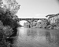
The Blackstone River at Ashton, Rhode Island, with the Ashton Viaduct.


