
Blackstone, Massachusetts facts for kids
Quick facts for kids
Blackstone, Massachusetts
|
|||
|---|---|---|---|

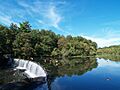
Rolling Dam on the Blackstone River
|
|||
|
|||
| Motto(s):
"Do well and doubt not."
|
|||

Location in Worcester County and Massachusetts.
|
|||
| Country | United States | ||
| State | Massachusetts | ||
| County | Worcester | ||
| Settled | 1662 | ||
| Incorporated | 1845 | ||
| Government | |||
| • Type | Open town meeting | ||
| Area | |||
| • Total | 11.2 sq mi (29.1 km2) | ||
| • Land | 10.9 sq mi (28.2 km2) | ||
| • Water | 0.3 sq mi (0.9 km2) | ||
| Elevation | 186 ft (57 m) | ||
| Population
(2020)
|
|||
| • Total | 9,208 | ||
| • Density | 822/sq mi (316.4/km2) | ||
| Time zone | UTC-5 (Eastern) | ||
| • Summer (DST) | UTC-4 (Eastern) | ||
| ZIP code |
01504
|
||
| Area code(s) | 508 / 774 | ||
| FIPS code | 25-06015 | ||
| GNIS feature ID | 0619477 | ||


Blackstone is a friendly town located in Worcester County, Massachusetts, in the United States. In 2020, about 9,208 people called Blackstone home. It's also part of the larger Providence metropolitan area, which means it's connected to a bigger group of towns and cities.
Contents
Discovering Blackstone's Past
This area was first home to the Nipmuc people. European settlers arrived in Blackstone in 1662. The town officially became its own separate place in 1845. Before that, it was part of a nearby town called Mendon, Massachusetts.
Blackstone got its name from William Blaxton. He was one of the first European settlers in New England. He was also the very first European to settle in both Rhode Island and Boston.
The town of Blackstone is located within the John H. Chaffee Blackstone River Valley National Heritage Corridor. This special area stretches across parts of Massachusetts and Rhode Island.
Exploring Blackstone's Geography
Blackstone covers an area of about 11.2 square miles. Most of this is land, with a small part being water. The famous Blackstone River flows along the southern edge of the town. This river is very important because it's known as the birthplace of the Industrial Revolution in the United States.
Neighboring Towns and Cities
Blackstone shares its borders with several other towns and cities:
- To the south, you'll find North Smithfield, Rhode Island and Woonsocket, Rhode Island.
- To the west is Millville, Massachusetts.
- Mendon, Massachusetts is to the north.
- To the east, you'll find Bellingham, Massachusetts.
Places Within Blackstone
Blackstone has several smaller areas or villages within its borders. Some of these include:
- Blackstone Village
- Central Village
- East Blackstone
- Farnum's Gate
- Five Corners
- High Rocks
- Millerville
- New City
- Privilege
- Rural District
- Waterford
- Wheelockville
- Woonsocket Junction (a former railroad spot)
There used to be a train station called East Blackstone. It was actually located in Bellingham.
Blackstone's Population Over Time
| Historical population | ||
|---|---|---|
| Year | Pop. | ±% |
| 1850 | 4,391 | — |
| 1860 | 5,453 | +24.2% |
| 1870 | 5,421 | −0.6% |
| 1880 | 4,907 | −9.5% |
| 1890 | 6,138 | +25.1% |
| 1900 | 5,721 | −6.8% |
| 1910 | 5,648 | −1.3% |
| 1920 | 4,299 | −23.9% |
| 1930 | 4,674 | +8.7% |
| 1940 | 4,566 | −2.3% |
| 1950 | 4,968 | +8.8% |
| 1960 | 5,130 | +3.3% |
| 1970 | 6,566 | +28.0% |
| 1980 | 6,570 | +0.1% |
| 1990 | 8,023 | +22.1% |
| 2000 | 8,804 | +9.7% |
| 2010 | 9,026 | +2.5% |
| 2020 | 9,208 | +2.0% |
| 2022* | 9,211 | +0.0% |
| * = population estimate. Source: United States Census records and Population Estimates Program data. |
||
In 2000, there were 8,804 people living in Blackstone. There were 3,235 households, which are groups of people living together. About 2,355 of these were families.
Many households, about 38.2%, had children under 18 living there. Most households, 58.9%, were married couples. About 22.4% of all households were single individuals. The average household had about 2.71 people.
The town's population included people of all ages. About 27.7% were under 18 years old. The median age was 35 years. This means half the people were younger than 35, and half were older.
Education in Blackstone
Blackstone is part of the Blackstone-Millville Regional School District. This district serves both Blackstone and its neighbor, Millville.
Blackstone-Millville Regional High School
The town is home to the Blackstone-Millville Regional High School. This school provides education for older students from both Blackstone and Millville.
Middle and Elementary Schools
In 2003, a new middle school was built. It is called the Frederick W. Hartnett Middle School. It was named after a former superintendent of schools. Blackstone also has two elementary schools: the Augustine F. Maloney Elementary School and the John F. Kennedy Elementary School.
Well-Known People from Blackstone
Many interesting people have come from Blackstone. Here are a few:
- Perley Dunn Aldrich, a talented composer.
- Con Daily, a baseball player.
- Matthew Dicks, an author.
- Eddie Eayrs, a baseball pitcher and outfielder.
- Ambrose Kennedy, a politician.
- Donald Pelletier, a religious leader.
- Bob Stewart, a baseball umpire.
- Fernand St. Germain, a politician.
- Eva March Tappan, an author.
- Webster Thayer, a judge.
- Gilbert Thompson, a typographer.
Images for kids
-
Rolling Dam on the Blackstone River
See also
 In Spanish: Blackstone (Massachusetts) para niños
