
Branch River (Rhode Island) facts for kids

The Branch River is a cool river located in the U.S. state of Rhode Island. It flows for about 16 kilometers (or 10 miles). This river has six dams along its path. Long ago, in the 1800s, the river's strong current helped power many textile mills in the area. These mills used the river's energy to make cloth and other goods.
Contents
Where the Branch River Flows
The Branch River starts in a town called Burrillville. It forms when two other rivers, the Clear River and the Chepachet River, join together. From there, it flows north through North Smithfield. It passes by towns like Slatersville and Forestdale. Finally, the Branch River flows into the larger Blackstone River.
Roads Crossing the River
Many roads and bridges cross over the Branch River. This list shows some of the main crossings, starting from where the river begins and moving downstream:
- In Burrillville:
- Victory Highway
- Broncos Highway (RI 102) (It crosses twice!)
- Douglas Pike (RI 7)
- In North Smithfield:
- Main Street
- Railroad Street
- Rhode Island State Route 146
- Great Road (RI 146A)
Rivers That Feed the Branch River
A tributary is a smaller stream or river that flows into a larger river. The Branch River has two named tributaries: Trout Brook and Dawley Brook. It also gets water from many other smaller streams that don't have specific names. These smaller waterways help keep the Branch River flowing!
Images for kids
-
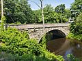
This is a stone arch bridge that carries Route 7 over the river in Nasonville.

