
Clear River (Rhode Island) facts for kids
The Clear River is a river located in the American state of Rhode Island. It flows for about 10.1 miles (16.3 km) (which is about 16.2 kilometers). Along its path, there are five dams.
Where the Clear River Flows
The Clear River begins in a swampy area southeast of Wallum Lake in a town called Burrillville. From there, the river generally flows towards the east. It passes by the small villages of Pascoag and Harrisville. When it reaches Oakland, the Clear River joins with the Chepachet River. When these two rivers meet, they form a new river called the Branch River.
Bridges and Crossings
Many roads and paths cross over the Clear River as it flows through Rhode Island. These crossings include local roads within Burrillville and also larger state routes like Route 107, Route 98, and Route 102. Bridges are built to allow people and vehicles to travel over the river safely.
Images for kids
-
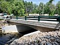
Railroad Avenue bridge in Burrillville

