
Narragansett Bay facts for kids
Quick facts for kids Narragansett Bay |
|
|---|---|
 |
|
| Lua error in Module:Location_map at line 420: attempt to index field 'wikibase' (a nil value). | |
| Location | Rhode Island, Massachusetts, United States |
| Type | Bay |
| Surface area | 147 square miles (380 km2) |
Narragansett Bay is a large bay and estuary (where fresh and saltwater mix) located mostly in Rhode Island, USA. It's like a giant natural harbor and has many islands. This bay is the biggest estuary in New England. A small part of it also reaches into Massachusetts.
More than 30 islands are found in the bay. The three biggest are Aquidneck Island, Conanicut Island, and Prudence Island. Other water areas connected to Narragansett Bay include the Sakonnet River, Mount Hope Bay, and the lower part of the Taunton River. The bay opens up to Rhode Island Sound and the Atlantic Ocean. Block Island is not far from its entrance.
Contents
What Does Narragansett Mean?
The name "Narragansett" comes from an old Algonquian word. It means "(people) of the small point of land." This name refers to the Narragansett people who lived around the bay.
Exploring Narragansett Bay's Geography

The land area that drains into Narragansett Bay is called its watershed. This watershed has seven main river areas. Important rivers like the Taunton River, Pawtuxet River, and Blackstone River flow into the bay. These rivers bring a lot of fresh water into the bay every day. The amount of river water changes with the seasons. More water flows in during spring, and less in early fall.
The bay itself is a ria (a drowned river valley). It was formed when river valleys were flooded by the ocean. The bay has three main parts: the Sakonnet River valley, the East Passage, and the West Passage. The depth of these parts is very different. The East Passage is the deepest, while the West Passage and Sakonnet River are shallower.
Providence is the capital and largest city of Rhode Island. It is located at the very top (northernmost part) of the bay. Many towns near Providence are also on the bay. These include East Providence, Warwick, and Cranston. Newport is a city at the southern end of Aquidneck Island, right by the ocean. It is home to important naval centers. The city of Fall River, Massachusetts is in Massachusetts, at the point where the Taunton River meets Mount Hope Bay. This area is the northeastern part of Narragansett Bay. On the southwest side of the bay, you'll find popular tourist towns like Narragansett and Wickford.
How Water Moves in Narragansett Bay
Understanding Tides
Tides are the regular rise and fall of ocean water. In Narragansett Bay, tides are measured at several places like Providence and Newport. Scientists use sound waves or special sensors on the ocean floor to measure how high the water is.
The bay has "semi-diurnal" tides. This means there are two high tides and two low tides every day. The height difference between high and low tide is about 3.6 feet (1.1 meters) at the bay's entrance and 4.6 feet (1.4 meters) at its top. The tides change about every 12.42 hours. This means two full tides happen every 24 hours and 50 minutes. The biggest tides (spring tides) and smallest tides (neap tides) happen about every 14.8 days.
Water Flow and Mixing
The way water moves around in a bay is called its circulation. Narragansett Bay is mostly "well-mixed." This means the fresh river water and salty ocean water mix together quite well. However, near the Providence River, the water can sometimes form layers, with fresher water on top.
The movement of water in Narragansett Bay is caused by winds, tides, and differences in water density (how heavy the water is). It's also affected by fresh water flowing in from rivers and salty water coming in from the ocean. Water usually stays in the bay for about 10 to 40 days, with an average of 26 days. Tidal currents are very strong and are the main force moving water in the bay. They can reach speeds of up to 2.5 feet per second (0.76 meters per second).
Winds also play a role. In winter, winds from the northwest push water towards the ocean. In summer, winds from the southwest push water towards the top of the bay. Strong winds can also create waves that help mix the surface water.
Differences in water density also affect circulation. Fresh water comes from rain and rivers, as well as from water treatment plants. When fresh water mixes with salty ocean water, the salinity (saltiness) changes. It's less salty near the Providence River (about 24 parts per thousand) and saltier at the bay's mouth (about 32 parts per thousand).
The currents and water movement in the bay also affect where sediment (like sand and mud) settles. Finer materials like clay and silt are often found in the harbors. Heavier, coarser materials like gravel are found in the lower parts of the bay where the water moves faster.
Early History of Narragansett Bay

Europeans likely first visited Narragansett Bay in the early 1500s. At that time, two Native American tribes lived around the bay. The Narragansetts lived on the west side, and the Wampanoags lived on the east side, stretching towards Cape Cod.
Many historians believe that the first European contact was made by Giovanni da Verrazzano. He was an Italian explorer who sailed into the bay in 1524 on his ship La Dauphine. Verrazzano called the bay Refugio, meaning "the Refuge." We don't know his exact route, but he reported finding open forests perfect for travel. Later, in 1614, a Dutch sailor named Adriaen Block explored and mapped the bay. Block Island is named after him.
The first lasting European settlement was started in 1636 by Roger Williams. He had left the Massachusetts Bay Colony. Williams became friends with Canonicus, a leader of the Narragansett people. Canonicus gave him land to build Providence Plantations. Around the same time, the Dutch set up a trading post nearby. In 1643, Roger Williams got a special paper from England to create the Colony of Rhode Island and Providence Plantations.

The Gaspee Affair was an important event that helped lead to the American Revolution. It happened in Narragansett Bay in 1772. A British ship called the Gaspee was captured and burned by American colonists. This event helped push the Thirteen Colonies closer to war. Today, the Gaspee Days Celebration is held in Pawtuxet Village every June to remember this event.
Early colonists named some of the bay's islands: Prudence, Patience, Hope, Despair, and Hog. To help remember them, children used to say a poem: "Patience, Prudence, Hope, and Despair. And the little Hog over there."
Water Quality and Tiny Plants
Narragansett Bay is split into east and west passages by Conanicut Island. The bay is about 9.0 meters (30 feet) deep on average. The west passage is shallower, and the east passage is deeper. Fresh water flows into Narragansett Bay from several places. About 80% comes from rivers, 13% from rain, and 9% from wastewater treatment plants. Some also comes from groundwater and overflow from sewers after heavy rain.
The amount of fresh water changes a lot with the seasons. It's highest in winter and lowest in summer. When fresh water mixes with sea water, the saltiness (salinity) changes. It goes from about 24 parts per thousand (ppt) near the Providence River to 32 ppt at the bay's mouth. Water temperatures in the bay range from -0.5°C (31°F) to 24°C (75°F) throughout the year.
Dissolved oxygen levels in Narragansett Bay also change with the seasons. They are lower in summer and higher in winter. This is because warmer water holds less oxygen, and living things use more oxygen in summer. Sometimes in summer, the northern part of the bay can have very low oxygen levels, which is called hypoxia.
Phytoplankton are tiny plant-like organisms that float in the water. They are the base of the food chain for many sea animals in the bay. There are more phytoplankton near the Providence River and fewer near Rhode Island Sound. This matches how nutrients (food for phytoplankton) are spread in the bay. Near the Providence River, there are most phytoplankton in summer. In the east and west passages, they peak in spring and fall.
Over the last ten years, the amount of phytoplankton has decreased. This is because less nitrogen (an important nutrient for them) is flowing into the bay. Wastewater treatment plants have gotten better at removing nitrogen.
Scientists at the University of Rhode Island have been studying plankton in Narragansett Bay since 1957. This is one of the longest ongoing studies of plankton in the world! They collect samples every week and have found 246 different species.
Rivers Flowing into Narragansett Bay


- Blackstone River, flowing through Woonsocket, Cumberland, Lincoln, Central Falls, and Pawtucket, RI
- Seekonk River, flowing through Pawtucket, East Providence, and Providence, RI
- Ten Mile River, flowing through Pawtucket and East Providence, RI
- Moshassuck River, flowing through Providence, RI
- Woonasquatucket River, flowing through Providence, RI
- Providence River, flowing through Providence, Cranston, Warwick, East Providence, and Barrington, RI
- Pawtuxet River, flowing through Cranston and Warwick, RI
- Potowomut River, also called Greene River, flowing through Warwick, and North Kingstown, RI
- Quequechan River, flowing through Fall River, MA
- Barrington River, flowing through Barrington, RI
- Palmer River, flowing through Barrington and Warren, RI
- Warren River, flowing through Warren and Barrington, RI
- Taunton River, flowing through Fall River, MA
- Sakonnet River, flowing through Tiverton, Little Compton, Portsmouth, and Middletown, RI
- Kickemuit River, flowing through Warren and Bristol, RI
Images for kids
-
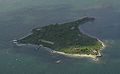
The name of Rose Island is attributed to the island's rose shape at low tide.

See also
 In Spanish: Bahía Narragansett para niños
