
Providence River facts for kids
Quick facts for kids Providence River |
|
|---|---|

The Providence River and Downtown Providence
|
|
| Country | United States |
| State | Rhode Island |
| County | Providence |
| Physical characteristics | |
| Main source | confluence of Woonasquatucket and Moshassuck Rivers 41°49′36″N 71°24′36″W / 41.8267°N 71.4100°W |
| River mouth | Narragansett Bay 41°43′16″N 71°20′53″W / 41.721°N 71.348°W |
| Length | 8 mi (13 km) |

The Providence River is a tidal river in Rhode Island, USA. This means its water level changes with the ocean's tides. It flows for about 8 miles (13 km). There are no dams on the river. However, the Fox Point Hurricane Barrier protects the city of Providence from big tidal floods.
The southern part of the river has been dredged. This means the bottom of the river was dug out to make it deeper. This project cost $65 million. It helps boats and ships use the river more easily.
Long ago, the Dutch called this river the Nassau River. It was the northern border of land claimed by the Dutch in the 1600s. This was because Adriaen Block explored Narragansett Bay in 1614. The river was seen as the original border between the English colonies of New England and the Dutch colony of New Netherland until 1650.
Contents
Where the Providence River Flows
The Providence River starts in downtown Providence. It is formed when two other rivers, the Woonasquatucket and Moshassuck rivers, join together.
About half a mile downstream, the Seekonk River joins it from the east. The Providence River then continues flowing south.
Cities Along the River
Several cities and towns are located along the river's banks:
- To the west are Providence, Cranston, and Warwick.
- To the east are East Providence and Barrington.
The river connects to Narragansett Bay. A lighthouse called Conimicut Shoal Lighthouse marks the entrance to the river from the bay. It is located between Conimicut Point in Warwick and Nayatt Point in Barrington.
Fun Things to Do on the River
Since the late 1990s, the Providence River has become famous for Gondola rides. These rides are popular with both tourists and local people. You can enjoy them daily during the warmer months.
Providence has three gondolas and one "sondolo." These boats are handmade in Italy. Together, they make up one of the largest groups of gondolas in the United States.
Bridges Over the Providence River
Many bridges cross the Providence River. They connect different parts of the cities and towns. Here is a list of the crossings, starting from where the river begins and moving downstream:
- Providence
- Washington Place
- College Street
- Crawford Street
- Old Interstate 195
- Point Street Bridge
- Fox Point Hurricane Barrier
- Providence River Bridge (I-195)
- Providence River Pedestrian and Bicycle Bridge
Rivers That Flow Into the Providence River
Several smaller rivers flow into the Providence River. These are called tributaries. They add water to the main river.
Images for kids
-
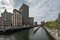
The Providence River and Downtown Providence
-
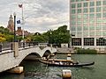
A gondola sails under the Crawford Street Bridge
-
The Crawford Street Bridge extends over the Providence River, connecting Downtown Providence to the East Side
-
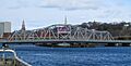
Point Street Bridge, spanning the Providence River
-

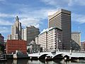
The skyline of the city of Providence viewed from across the Providence River


