Providence County, Rhode Island facts for kids
Quick facts for kids
Providence County
|
|
|---|---|

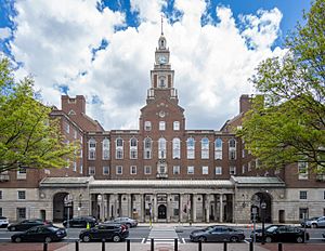
Providence County Courthouse
|
|
| Country | |
| State | |
| Region | New England |
| Metro area | Providence |
| Formed | June 22, 1703 |
| Named for | Providence, Rhode Island |
| County town | Providence |
| Largest city | Providence |
| Incorporated municipalities |
16 (total)
6 cities, 10 towns
|
| Area | |
| • Total | 436 sq mi (1,130 km2) |
| • Land | 410 sq mi (1,100 km2) |
| • Water | 26 sq mi (70 km2) 6%% |
| Highest elevation | 812 ft (247 m) |
| Lowest elevation | 0 ft (0 m) |
| Population | |
| • Total | 660,741 |
| • Density | 1,611/sq mi (622/km2) |
| GDP | |
| • Total | $42.588 billion (2022) |
| Time zone | UTC−5 (EST) |
| • Summer (DST) | UTC−4 (EDT) |
| ZIP Code format |
028xx, 029xx
|
| Area code | 401 |
| FIPS code | 44-007 |
| GNIS feature ID | 1219781 |
| Congressional district | 1st, 2nd |
Providence County is the county with the most people in the U.S. state of Rhode Island. In 2020, about 660,741 people lived here. This means over 60% of Rhode Island's population calls Providence County home!
The county is home to the city of Providence. This city is the capital of Rhode Island and also the largest city in the county. About 190,934 people lived in Providence in 2020.
Providence County is part of a larger area called the Providence-Warwick Metropolitan Statistical Area. This area also includes parts of Massachusetts. It's even part of a bigger region that stretches into New Hampshire and Connecticut.
Contents
History of Providence County
Providence County was first created on June 22, 1703. Back then, it was called the County of Providence Plantations. It included five towns: Providence, Warwick, Westerly, Kingstown, and Greenwich. These towns covered areas that are now Kent and Washington counties.
Later, Washington County was separated in 1729. Kent County also became its own county in 1750. The town of Cumberland joined Providence County in 1746–47. Then, East Providence and Pawtucket became part of the county in 1862. This happened when the border with Massachusetts was finally decided.
In 1842, the county government in Rhode Island was stopped. Today, Providence County doesn't have its own government. Instead, it's mainly used for things like court areas and sheriff's duties, which are handled by the state government.
Geography of Providence County
Providence County covers about 436 square miles. Most of this area, about 410 square miles, is land. The rest, about 26 square miles, is water. It's the largest county in Rhode Island by land area.
Several rivers flow through the county. The Blackstone River runs along the eastern border. The Woonasquatucket River flows through the middle. It joins with the smaller Moshassuck River in downtown Providence. The Pawtuxet River forms part of the southeastern border.
A large dam on the Pawtuxet River creates the Scituate Reservoir. This reservoir provides drinking water for Providence and nearby towns.
The highest point in Providence County, and all of Rhode Island, is Jerimoth Hill. It stands at 812 feet (247 meters) above sea level. The lowest point is sea level itself.
Neighboring Counties
Providence County shares borders with several other counties:
- Norfolk County, Massachusetts - to the northeast
- Bristol County, Massachusetts - to the east
- Bristol County - to the southeast
- Kent County - to the south
- Windham County, Connecticut - to the west
- Worcester County, Massachusetts - to the northwest
Protected Natural Areas
You can find parts of these special natural areas in Providence County:
Main Roads and Highways
Many important roads and highways cross Providence County, connecting different towns and cities. These include major interstates and state routes:
 I-95
I-95 I-195
I-195 I-295
I-295 US 1
US 1 US 1A
US 1A US 6
US 6 US 6A
US 6A US 44
US 44 Route 2
 Route 5
 Route 7
 Route 10
 Route 12
 Route 14
 Route 15
 Route 33
 Route 37
 Route 51
 Route 94
 Route 96
 Route 98
 Route 99
 Route 100
 Route 102
 Route 103
 Route 103A
 Route 104
 Route 107
 Route 108
 Route 114
 Route 114A
 Route 115
 Route 116
 Route 117
 Route 120
 Route 121
 Route 122
 Route 123
 Route 126
 Route 128
 Route 146
 Route 146A
 Route 152
People of Providence County
| Historical population | |||
|---|---|---|---|
| Census | Pop. | %± | |
| 1790 | 24,376 | — | |
| 1800 | 25,854 | 6.1% | |
| 1810 | 30,869 | 19.4% | |
| 1820 | 35,736 | 15.8% | |
| 1830 | 47,018 | 31.6% | |
| 1840 | 58,073 | 23.5% | |
| 1850 | 87,526 | 50.7% | |
| 1860 | 107,799 | 23.2% | |
| 1870 | 149,190 | 38.4% | |
| 1880 | 197,874 | 32.6% | |
| 1890 | 255,123 | 28.9% | |
| 1900 | 328,683 | 28.8% | |
| 1910 | 424,353 | 29.1% | |
| 1920 | 475,190 | 12.0% | |
| 1930 | 540,016 | 13.6% | |
| 1940 | 550,298 | 1.9% | |
| 1950 | 574,973 | 4.5% | |
| 1960 | 568,778 | −1.1% | |
| 1970 | 580,261 | 2.0% | |
| 1980 | 571,349 | −1.5% | |
| 1990 | 596,270 | 4.4% | |
| 2000 | 621,602 | 4.2% | |
| 2010 | 626,667 | 0.8% | |
| 2020 | 660,741 | 5.4% | |
| U.S. Decennial Census 1790-1960 1900-1990 1990-2000 2010-2019 |
|||
In 2010, there were 626,667 people living in Providence County. The population density was about 1,530 people per square mile. Most people (73.4%) were white. About 8.5% were Black or African American, and 3.7% were Asian. People of Hispanic or Latino origin made up 18.8% of the population.
Many different cultures and backgrounds make up Providence County. Some of the largest ancestry groups include:
In 2010, about 31.4% of households had children under 18 living with them. The average household had 2.48 people. The average age of people in the county was 37 years old.
Communities in Providence County
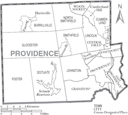
Providence County has many different cities and towns. Here are some of them:
Cities
- Central Falls
- Cranston
- East Providence
- Pawtucket
- Providence (This is the main county town)
- Woonsocket
Towns
Census-Designated Places (CDPs)
CDPs are areas that look like towns but are not officially incorporated as towns.
Other Villages
These are smaller communities within the towns.
Education in Providence County
Providence County has many school districts that serve students from kindergarten through high school.
School Districts
- Burrillville School District
- Central Falls School District
- Cranston School District
- Cumberland School District
- East Providence School District
- Johnston School District
- Lincoln School District
- North Providence School District
- North Smithfield School District
- Pawtucket School District
- Providence School District
- Scituate School District
- Smithfield School District
- Woonsocket School District
Regional and Specialized Schools
Some districts work together for high schools, like the Foster-Glocester Regional School District. There are also elementary school districts like Foster and Glocester. The state also runs a special school, the Rhode Island School for the Deaf.
See also
 In Spanish: Condado de Providence para niños
 | Toni Morrison |
 | Barack Obama |
 | Martin Luther King Jr. |
 | Ralph Bunche |


