Bristol County, Rhode Island facts for kids
Quick facts for kids
Bristol County
|
|
|---|---|

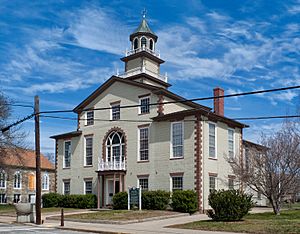
Bristol County Courthouse in Bristol
|
|
| Country | |
| State | |
| Region | New England |
| Metro area | Providence |
| Formed | February 17, 1747 |
| Named for | Bristol, England |
| County town | Bristol |
| Largest town | Bristol |
| Incorporated municipalities | 3 towns |
| Area | |
| • Total | 45 sq mi (120 km2) |
| • Land | 24 sq mi (60 km2) |
| • Water | 21 sq mi (50 km2) 46%% |
| Highest elevation | 221 ft (67 m) |
| Lowest elevation | 0 ft (0 m) |
| Population | |
| • Total | 50,793 |
| • Density | 1,128.7/sq mi (435.8/km2) |
| GDP | |
| • Total | $2.286 billion (2022) |
| Time zone | UTC−5 (EST) |
| • Summer (DST) | UTC−4 (EDT) |
| ZIP Code format |
028xx
|
| Area code | 401 |
| FIPS code | 44-001 |
| GNIS feature ID | 1219777 |
| Congressional district | 1st |
Bristol County is a small but interesting area in the state of Rhode Island. It's a "county," which is like a region or division within a state. In 2020, about 50,793 people lived here. This makes it the county with the fewest people in Rhode Island. It's also super tiny in terms of land! It's the third-smallest county in the entire United States, covering only about 24 square miles (62 square kilometers) of land. Bristol County was formed a long time ago, in 1747. It's part of a bigger area called the Providence Metropolitan Statistical Area, which includes cities like Providence and Warwick.
Contents
History of Bristol County
Bristol County was created in 1747. Before that, it was part of Bristol County, Massachusetts. There was a long disagreement about where the border between the two areas should be.
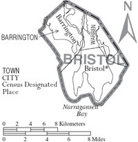
The original county was part of the Plymouth Colony. It was named after its main town, which is now Bristol, Rhode Island. When the new Rhode Island county was formed in 1747, it included the towns of Bristol, Barrington, and Warren, just as it does today.
Geography of Bristol County
Bristol County is very small. It has a total area of about 45 square miles (117 square kilometers). About 24 square miles (62 square kilometers) of this is land, and the other 21 square miles (54 square kilometers) is water. This means almost half of the county is water!
It is the smallest county in Rhode Island. If you only count the land area, it's the third-smallest county in the whole United States. Only Kalawao County in Hawaii and New York County (Manhattan) in New York are smaller. The highest point in Bristol County is Mount Hope, which is 217 feet (66 meters) above sea level. You can find Mount Hope in the town of Bristol.
Neighboring Counties
Bristol County shares its borders with a few other counties:
- Bristol County, Massachusetts: to the east
- Providence County: to the north
- Kent County: to the west
- Newport County: to the south
People of Bristol County (Demographics)
The number of people living in Bristol County has changed over many years. Here's how the population has grown:
| Historical population | |||
|---|---|---|---|
| Census | Pop. | %± | |
| 1790 | 3,211 | — | |
| 1800 | 3,801 | 18.4% | |
| 1810 | 5,072 | 33.4% | |
| 1820 | 5,637 | 11.1% | |
| 1830 | 5,446 | −3.4% | |
| 1840 | 6,476 | 18.9% | |
| 1850 | 8,514 | 31.5% | |
| 1860 | 8,907 | 4.6% | |
| 1870 | 9,421 | 5.8% | |
| 1880 | 11,394 | 20.9% | |
| 1890 | 11,428 | 0.3% | |
| 1900 | 13,144 | 15.0% | |
| 1910 | 17,602 | 33.9% | |
| 1920 | 23,113 | 31.3% | |
| 1930 | 25,089 | 8.5% | |
| 1940 | 25,548 | 1.8% | |
| 1950 | 29,079 | 13.8% | |
| 1960 | 37,146 | 27.7% | |
| 1970 | 45,937 | 23.7% | |
| 1980 | 46,942 | 2.2% | |
| 1990 | 48,859 | 4.1% | |
| 2000 | 50,648 | 3.7% | |
| 2010 | 49,875 | −1.5% | |
| 2020 | 50,793 | 1.8% | |
| U.S. Decennial Census 1790–1960 1900–1990 1990–2000 2010–2019 |
|||
What the 2010 Census Showed
In 2010, there were 49,875 people living in Bristol County. Most people (95.7%) were white. Smaller groups included Asian (1.4%), Black or African American (0.8%), and American Indian (0.2%). About 2.0% of the people were of Hispanic or Latino background.
Many people in Bristol County have family roots from different countries. The largest groups of people by ancestry were:
- 24.8% Portuguese
- 22.2% Irish
- 21.0% Italian
- 14.5% English
- 9.8% French
- 8.1% German
The average age of people in the county was about 42.9 years old. The average income for a household was around $68,333 per year.
Towns in Bristol County
Bristol County has three main towns:
- Barrington
- Bristol (This is the traditional county seat, or main town for the county's government)
- Warren
Education in Bristol County
There are two main school districts that serve the students in Bristol County:
- Barrington School District
- Bristol-Warren Regional School District
See also
 In Spanish: Condado de Bristol (Rhode Island) para niños
 | James Van Der Zee |
 | Alma Thomas |
 | Ellis Wilson |
 | Margaret Taylor-Burroughs |


