
Bristol, Rhode Island facts for kids
Quick facts for kids
Bristol, Rhode Island
|
|
|---|---|
|
Town
|
|

(L–R) Walley School (1896), First Baptist Church (1814), and Bristol County Statehouse/Courthouse (1816) on the town common
|
|

Location in Bristol County and the state of Rhode Island
|
|
| Country | United States |
| State | Rhode Island |
| County | Bristol |
| Settled | 1680 |
| Incorporated | October 28, 1681 |
| Annexed from Massachusetts | January 27, 1747 |
| Government | |
| • Type | Mayor-council |
| Area | |
| • Total | 20.6 sq mi (53.4 km2) |
| • Land | 10.1 sq mi (26.2 km2) |
| • Water | 10.5 sq mi (27.2 km2) |
| Elevation | 0–131 ft (0–40 m) |
| Population
(2020)
|
|
| • Total | 22,493 |
| • Density | 2,224/sq mi (858.5/km2) |
| Time zone | UTC−5 (EST) |
| • Summer (DST) | UTC−4 (EDT) |
| ZIP Code |
02809
|
| Area code(s) | 401 |
| FIPS code | 44-09280 |
| GNIS feature ID | 1220083 |
| Demonym | Bristolian ("brihs-TOH-lee-an") |
Bristol is a town in Bristol County, Rhode Island, United States. It is also the main town of Bristol County. In 2020, about 22,493 people lived there. Bristol is a deep-water seaport, meaning large ships can easily dock there. It was named after Bristol, England.
The town is known for building boats and other ocean-related businesses. It also has manufacturing and a growing tourism industry. Bristol and the nearby town of Warren share a school system. Many people in Bristol have Portuguese-American or Italian-American backgrounds.
Contents
Bristol's Past: A Look at History
Early Days and Native Americans
Before the Pilgrims arrived in 1620, the Pokanokets lived in much of Southern New England. This included the area where Bristol is now. The Pokanokets had faced many diseases that greatly reduced their population. Their leader, Massasoit Osamequin, became friends with the early European settlers.
Later, a big conflict called King Philip's War happened between the settlers and the Pokanokets. This war started near Bristol. The Pokanoket leader, Metacomet (also known as King Philip), used Mount Hope as his main base. He died there in 1676. A rocky spot on the mountain, called "Massasoit's Seat," was once a lookout point for spotting enemy ships.
After the war, some merchants from Boston bought land in the area. Bristol was part of Massachusetts until 1747. That's when it became part of the Rhode Island Colony. A main road in Bristol, Metacom Avenue, is named after Metacomet.
The DeWolf Family and the Slave Trade
The DeWolf family was one of the first families to settle in Bristol. Bristol and Rhode Island became important centers for the slave trade. This trade brought a lot of wealth to the area. James DeWolf, a powerful slave trader, later became a U.S. Senator for Rhode Island.
From 1769 until 1820, the DeWolf family bought and sold over 10,000 people from West Africa. These enslaved people were forced to work on DeWolf-owned farms or sold in places like Havana, Cuba, and Charleston, South Carolina. Sugar and molasses from these farms were brought to Rhode Island for DeWolf-owned factories. By 1820, James DeWolf was one of the richest people in the United States.
Some Quakers in Rhode Island were early supporters of ending slavery. The story of the DeWolf family and Bristol's role in the slave trade is shared in a 2008 documentary called Traces of the Trade: A Story from the Deep North.
American Revolution in Bristol

During the American Revolutionary War, the British navy attacked Bristol twice. On October 7, 1775, British ships fired on the town when their demands for supplies were refused. This caused a lot of damage.
A second attack happened on May 25, 1778. About 500 British and Hessian (German) soldiers marched through the town. They burned 30 buildings and took some people prisoner.
New Goree Community
Starting around 1805, a community of free Black people lived in Bristol. This area was called "New Goree." It was located along Wood Street. This community was no longer there by 1900. An African Methodist Episcopal church once stood on Wood Street, but it was torn down by 1898.
Bristol Today
Until 1854, Bristol was one of the five state capitals of Rhode Island.
Today, Bristol is home to Roger Williams University, named after the founder of Rhode Island, Roger Williams.
The East Bay Bike Path ends in Bristol at Independence Park. This bike path follows an old railroad track and goes north to Providence. It offers great views of Narragansett Bay.
The Herreshoff boat company in Bristol built five winning boats for the America's Cup races between 1893 and 1920. Colt State Park used to be the home of Samuel P. Colt. He was the founder of the United States Rubber Company, which became Uniroyal. Colt State Park has beautiful gardens and amazing views of Narragansett Bay.
The Joseph Reynolds House in Bristol is a National Historic Landmark. It was built in 1700. During the American Revolutionary War, the Marquis de Lafayette used it as his headquarters in 1778.
Bristol's Fourth of July Parade

Bristol has the oldest continuous Independence Day celebration in the United States. The first celebration was in July 1777. A British officer wrote about hearing cannons fired from across Narragansett Bay. This was to celebrate the first anniversary of the Declaration of Independence.
The official celebrations started in 1785. They were organized by a Revolutionary War veteran, Rev. Henry Wight. Today, the Bristol Fourth of July Committee continues these traditions. The festivities begin on June 14, Flag Day. They include outdoor concerts, soapbox car races, and a firefighters' muster.
The celebration ends on July 4 with "The Military, Civic and Firemen's Parade." This is the oldest annual parade in the U.S. Over 200,000 people come to Bristol for it. These big celebrations have given Bristol the nickname, "America's most patriotic town."
Local groups like the Bristol Train of Artillery and the Bristol County Fifes and Drums take part in the parade.
Bristol's Location and Weather
Bristol is located on a piece of land that sticks out into the water. This land is called a peninsula. Narragansett Bay is to its west, and Mount Hope Bay is to its east. The town covers about 10.1 square miles (26.2 square kilometers) of land. It also has about 10.5 square miles (27.2 square kilometers) of water. Bristol's harbor has more than 800 places for boats to dock.
Climate in Bristol
| Climate data for Bristol, Rhode Island | |||||||||||||
|---|---|---|---|---|---|---|---|---|---|---|---|---|---|
| Month | Jan | Feb | Mar | Apr | May | Jun | Jul | Aug | Sep | Oct | Nov | Dec | Year |
| Record high °F (°C) | 67 (19) |
64 (18) |
80 (27) |
89 (32) |
91 (33) |
94 (34) |
98 (37) |
96 (36) |
93 (34) |
83 (28) |
74 (23) |
70 (21) |
98 (37) |
| Mean daily maximum °F (°C) | 38 (3) |
40 (4) |
47 (8) |
58 (14) |
68 (20) |
77 (25) |
83 (28) |
82 (28) |
74 (23) |
64 (18) |
53 (12) |
43 (6) |
61 (16) |
| Mean daily minimum °F (°C) | 21 (−6) |
22 (−6) |
29 (−2) |
38 (3) |
48 (9) |
58 (14) |
64 (18) |
63 (17) |
56 (13) |
45 (7) |
35 (2) |
27 (−3) |
42 (6) |
| Record low °F (°C) | −7 (−22) |
−7 (−22) |
2 (−17) |
18 (−8) |
31 (−1) |
41 (5) |
50 (10) |
49 (9) |
35 (2) |
27 (−3) |
14 (−10) |
4 (−16) |
−7 (−22) |
| Average precipitation inches (mm) | 3.66 (93) |
3.34 (85) |
4.52 (115) |
3.90 (99) |
3.54 (90) |
3.90 (99) |
3.54 (90) |
4.03 (102) |
3.90 (99) |
4.64 (118) |
3.90 (99) |
4.52 (115) |
47.39 (1,204) |
| Average snowfall inches (cm) | 10 (25) |
10 (25) |
7.1 (18) |
1 (2.5) |
0 (0) |
0 (0) |
0 (0) |
0 (0) |
0 (0) |
0 (0) |
1 (2.5) |
7.1 (18) |
36.2 (91) |
People of Bristol
| Historical population | ||
|---|---|---|
| Year | Pop. | ±% |
| 1748 | 1,069 | — |
| 1755 | 1,080 | +1.0% |
| 1774 | 1,209 | +11.9% |
| 1776 | 1,067 | −11.7% |
| 1782 | 1,032 | −3.3% |
| 1790 | 1,406 | +36.2% |
| 1800 | 1,678 | +19.3% |
| 1810 | 2,698 | +60.8% |
| 1820 | 3,197 | +18.5% |
| 1830 | 3,084 | −3.5% |
| 1840 | 3,490 | +13.2% |
| 1850 | 4,616 | +32.3% |
| 1860 | 5,271 | +14.2% |
| 1870 | 5,302 | +0.6% |
| 1880 | 6,028 | +13.7% |
| 1890 | 5,478 | −9.1% |
| 1900 | 6,901 | +26.0% |
| 1910 | 8,565 | +24.1% |
| 1920 | 11,375 | +32.8% |
| 1930 | 11,953 | +5.1% |
| 1940 | 11,159 | −6.6% |
| 1950 | 12,320 | +10.4% |
| 1960 | 14,570 | +18.3% |
| 1970 | 17,860 | +22.6% |
| 1980 | 20,128 | +12.7% |
| 1990 | 21,625 | +7.4% |
| 2000 | 22,469 | +3.9% |
| 2010 | 22,954 | +2.2% |
| 2020 | 22,493 | −2.0% |
| U.S. Decennial Census | ||
In 2010, Bristol had a population of 22,954 people. Most of the people living in Bristol are White (94.9%). About 2.0% of the population is Hispanic or Latino.
Fun Places to Visit in Bristol
-
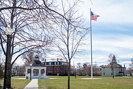
Bristol Town Common
-
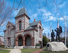
Ambrose Burnside Memorial
-
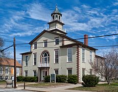
The Bristol County Statehouse/Courthouse
_Town_Common.jpg)

_State_House.jpg)


Bristol has many interesting places to see, including:
- America's Cup Hall of Fame (learn about famous boat races)
- Blithewold Mansion, Gardens and Arboretum (a beautiful old house with gardens)
- Bristol Art Museum
- Bristol County Courthouse (Rhode Island)
- Bristol Customshouse and Post Office
- Bristol Ferry Lighthouse
- Colt State Park (great for walks and views)
- Herreshoff Marine Museum (all about boat building)
- Linden Place (a historic home)
- Mount Hope Bridge (a large bridge)
- Joseph Reynolds House (a very old house from 1700)
- Roger Williams University (a local college)
Famous People from Bristol
Many notable people have connections to Bristol:
- William Thomas "Billy" Andrade: A professional golfer.
- Ethel Barrymore Colt: A famous silent film and stage actress.
- William Bradford (1729–1808): A doctor, lawyer, and important U.S. Senator.
- Ambrose Burnside: A railroad leader, U.S. Senator, and general during the Civil War.
- Sean Callery: An Emmy-winning composer.
- Samuel P. Colt: An entrepreneur who founded a large rubber company.
- James DeWolf (1764–1837): A very wealthy man who made much of his money from the slave trade.
- Nathanael Herreshoff: A naval architect who designed many winning boats for the America's Cup.
- Ira Magaziner: A senior advisor to President Bill Clinton.
- Chris Santos: A well-known chef and TV judge.
- Benjamin Franklin Tilley (1848–1907): A U.S. Navy rear admiral.
See also
 In Spanish: Bristol (Rhode Island) para niños
