East Bay Bike Path facts for kids
Quick facts for kids East Bay Bike Path |
|
|---|---|

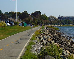
Facing south near the path's southern terminus in Bristol
|
|
| East Bay Bike Path | |
| Length | 14.5 miles (23.3 km) |
| Location | Providence County and Bristol County, Rhode Island |
| Established | 1992 |
| Designation | East Coast Greenway |
| Trailheads | India Point Park Bristol, Rhode Island |
| Use | Hiking, Walking, Cycling |
| Sights | Narragansett Bay |
| Surface | Asphalt |
| Website | East Bay Bike Path |
The East Bay Bike Path is a super cool paved trail in Rhode Island. It's about 14.5 miles long, which is like riding your bike for a really long time! This path starts in Providence at India Point Park. From there, it goes all the way southeast to Bristol.
As you travel, the path follows the beautiful shoreline of Narragansett Bay. You'll pass through different places like East Providence, Riverside, Barrington, and Warren. It's a great way to see many parts of Rhode Island!
This path is part of something even bigger called the East Coast Greenway. This is a huge system of trails that stretches for 3,000 miles. It connects places all the way from Maine to Key West in Florida! The East Bay Bike Path is very popular. About 1.1 million people use it every year for walking, running, and biking.
Discovering the East Bay Bike Path
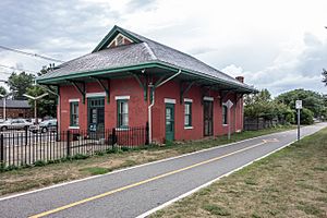
The East Bay Bike Path used to be a railroad track! It was part of the Providence, Warren and Bristol Railroad. This train line opened way back in 1855. It carried people and goods between Providence and Bristol, Rhode Island.
Over the years, the railroad changed owners a few times. Eventually, passenger trains stopped running on this line in 1937. Freight trains continued for a while. But by 1973, the railroad was no longer in use. It's interesting because in some spots, you can still see parts of the old train tracks next to the bike path!
How the Path Was Built
The idea for Rhode Island's first big bike path was approved in April 1983. This happened thanks to Governor Edward DiPrete. The path was built between 1987 and 1992. Workers used the old railroad bed to create the new trail.
The construction happened in four main parts:
- From Riverside Square to Barrington County Road (about 4.17 miles)
- From County Road in Barrington to Franklin Street in Warren (about 2.38 miles)
- From Franklin Street in Warren to Independence Park in Bristol (about 3.87 miles)
- From Riverside Square to India Point Park in Providence (about 3.98 miles)
The completed path was officially opened on May 31, 1992. Governor Bruce Sundlun was there for the special event. In 2011, an 8.5-mile bike lane was added. This new lane connects the East Bay Bike Path to the Blackstone River Greenway. The Blackstone River Bikeway is another long trail that will link Providence to Worcester, Massachusetts. Soon, the East Bay Bike Path will also connect to the Washington Secondary Rail Trail.
Keeping the Path in Great Shape
Like any outdoor area, the East Bay Bike Path needs care. Tree roots, rain, and weather can cause damage to the paved surface. Because of this, repairs have been made several times. These repairs happened in 2002, 2007, and 2009.
In mid-2016, more repairs were done. Workers fixed the most worn-out parts of the path. They repaired the pavement and removed tree roots that were causing problems. They also made sure areas that were eroding were strong again. Plus, new wooden planks were put on the bridges in Barrington.
A special part of the bike path was rebuilt between 2012 and 2015. This section is along the Washington Bridge. It's now called the George Redman Linear Park. It opened in September 2015. This new park has a wide bike lane and a separate walking path. There are also places to sit and rest. It's completely separate from the busy highway traffic, making it super safe! The park was named after George Redman, a cyclist from East Providence. You can see a plaque honoring him at the park's west end.
 | James B. Knighten |
 | Azellia White |
 | Willa Brown |


