
Harmony, Rhode Island facts for kids
Quick facts for kids
Harmony, Rhode Island
|
|
|---|---|

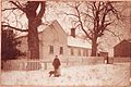
Harmony Chapel Cemetery on U.S. Route 44 around the start of the 20th century
|
|

Location of the CDP in Providence County and the state of Rhode Island.
|
|
| Country | United States |
| State | Rhode Island |
| County | Providence |
| Area | |
| • Total | 2.97 sq mi (7.68 km2) |
| • Land | 2.94 sq mi (7.62 km2) |
| • Water | 0.02 sq mi (0.06 km2) |
| Elevation | 554 ft (169 m) |
| Population
(2020)
|
|
| • Total | 1,036 |
| • Density | 352.02/sq mi (135.90/km2) |
| Time zone | UTC-5 (Eastern (EST)) |
| • Summer (DST) | UTC-4 (EDT) |
| ZIP code |
02814
|
| Area code(s) | 401 |
| FIPS code | 44-33040 |
| GNIS feature ID | 2629815 |
Harmony is a small village in Rhode Island, United States. It is located in Providence County within the town of Glocester. You can find Harmony along U.S. Route 44, also known as Putnam Pike. In 2020, about 1,036 people lived there.
Contents
Exploring Harmony's History and Landmarks
Harmony is home to some interesting historical spots.
Historic Chapel and Cemetery
The Harmony Chapel and Cemetery is a very old and important place in the village. It was built in 1816. You can find it right in the center of Harmony.
Local Attractions
If you visit Harmony, you'll find several restaurants to eat at. There's also the Harmony Library, where you can read and learn. For those who enjoy sports, there are golf courses nearby.
The Old Toll Booth
Long ago, in the early 1800s, there was a toll booth in Harmony. This booth was part of the Glocester Turnpike. People had to pay a small fee to use the road. This money helped keep the road in good condition. However, the toll booth was removed in the 1850s.
Harmony's Location and Size
Harmony is a small place in terms of its area.
Land and Water Area
The village covers about 2.97 square miles (7.68 square kilometers). Most of this area is land, about 2.94 square miles (7.62 square kilometers). Only a very small part, about 0.023 square miles (0.060 square kilometers), is water.
Who Lives in Harmony?
Learning about the people who live in Harmony helps us understand the community.
Population Count in 2020
| Historical population | |||
|---|---|---|---|
| Census | Pop. | %± | |
| 2020 | 1,036 | — | |
| U.S. Decennial Census | |||
The 2020 United States census counted 1,036 people living in Harmony. There were 415 households and 305 families. This means about 352 people lived in each square mile.
Most people in Harmony are white, making up about 91.22% of the population. There are also people from other backgrounds, including black or African-American residents (1.83%), and people of Hispanic or Latino heritage (3.67%). Some residents identify with two or more races.
Households and Families
About 22.4% of the households in Harmony had children under 18 years old. More than half, 56.4%, were married couples living together. About 24.6% of households were made up of individuals living alone. The average household had about 2.9 people.
Age Groups
The population of Harmony includes people of all ages.
- About 19.8% of the people were under 18 years old.
- Another 19.8% were between 25 and 44 years old.
- The largest group, 35.0%, was between 45 and 64 years old.
- About 17.4% of the population was 65 years or older.
The average age in Harmony was 48.5 years.
Images for kids
-
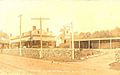
Yan-Yan-Ke Club in Harmony at the start of the 20th Century
-
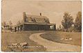
Warren Estate on Sawmill Road in Harmony
-
Sen. Arthur Steere's birthplace on the corner of Snake Hill & Sawmill Roads
-
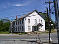
Laurel Grange on Snake Hill & Sawmill Road


See also
 In Spanish: Harmony (Rhode Island) para niños
