Scituate Reservoir facts for kids
Quick facts for kids Scituate Reservoir |
|
|---|---|

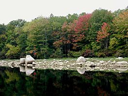
shoreline in early autumn
|
|
| Location | Scituate, Providence County, Rhode Island, United States |
| Coordinates | 41°46′21″N 71°36′39″W / 41.7724732°N 71.6108501°W |
| Type | Reservoir |
| Primary inflows | North Branch Pawtuxet River Moswansicut River Ponaganset River |
| Primary outflows | North Branch Pawtuxet River |
| Catchment area | 94 sq mi (240 km2) |
| Basin countries | United States |
| Max. length | 7 mi (11 km) |
| Max. width | 2.5 mi (4.0 km) |
| Surface area | 5.3 sq mi (14 km2) |
| Average depth | 32 ft (9.8 m) |
| Max. depth | 87 ft (27 m) |
| Water volume | 39×109 US gal (150,000,000 m3). |
| Shore length1 | 66 mi (106 km) |
| 1 Shore length is not a well-defined measure. | |
The Scituate Reservoir is the biggest inland body of water in the state of Rhode Island. It can hold about 39 billion US gallons (148 million m³) of water. Its surface covers 5.3 square miles (13.7 km²). This reservoir, along with six smaller ones, provides drinking water for over 60 percent of Rhode Island's people. This includes the city of Providence.
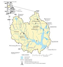
The area that collects water for the reservoir system is called a drainage basin. This basin is about 94 square miles (243.5 km²) big. It covers most of the town of Scituate. It also includes parts of Foster, Glocester, Johnston, and Cranston. The Providence Water Supply Board manages the Scituate Reservoir.
Contents
How the Reservoir Supplies Water
The Scituate Reservoir was made by building a large dam. This dam is made of earth and stretches across the North Branch Pawtuxet River. It is about 3,200 feet (975 meters) long and 100 feet (30 meters) high.
Moving Water to Your Tap
Water from the dam travels through a special channel called an aqueduct. This aqueduct leads to a nearby treatment plant. At the plant, the water is cleaned and filtered so it's safe to drink.
From the treatment plant, two main aqueducts carry the clean water. The first one is 90 inches (2,286 mm) wide and 4.5 miles (7.2 km) long. It splits into smaller pipes that deliver water to homes. The second aqueduct is 78 to 102 inches (1,981 to 2,591 mm) wide and 9.5 miles (15.3 km) long. It was built in the 1970s to help the first one. About 75% of the water flows by gravity, and 25% needs pumps. The whole system has 870 miles (1,400 km) of water mains, which are like big underground pipes.
History of the Scituate Reservoir
Providence first got its public water from the Pawtuxet River in Cranston. This system started on December 1, 1871. By 1910, Providence was growing fast with many factories. The water supply was not enough for everyone. During dry times, small reservoirs owned by mills had to provide extra water.
Planning a Bigger Water Source
In 1913, the Providence City Council created a Water Supply Board. Their job was to find a larger water source. They found a good spot at the top of the North Branch Pawtuxet River. This area also included the Moswansicut and Ponaganset Rivers. In 1915, a new Water Supply Board was formed. They had the power to start building the reservoir.
Building the Reservoir
Construction began in 1921. It was the biggest project ever in Rhode Island at that time. Workers even lived in a temporary village nearby. The reservoir was created by building a large earth dam across the Pawtuxet River. This was near the old village of Kent.
The reservoir started holding water on November 10, 1925. The water treatment plant began working on September 30, 1926. At the opening ceremony, Providence Mayor Joseph H. Gainer called it the "City's Greatest" project. He praised Frank E. Winsor, who led the work since 1915. The dam is now called the Gainer Memorial Dam in honor of the mayor.
The treatment plant was very advanced for its time. It was the only one like it in New England. It was updated in the 1940s and again in the 1960s. It can clean up to 144 million US gallons (545 million m³) of water each day.
Impact on the Community
Creating the reservoir meant that much of the town of Scituate was flooded. This included villages like Ashland, Kent, South Scituate, Richmond, and part of North Scituate. Providence bought 23.1 square miles (59.8 km²) of land. Most residents had to move and were paid for their property. Some people, like farmer Arthur Steere, sold a lot of land for the reservoir.
Between 1920 and 1930, Scituate's population dropped by 24 percent. This was the lowest number since the 1780s. Many buildings were torn down, including 375 homes, 233 barns, 7 schools, and 6 mills. About 30 dairy farms were lost, which changed farming in the town. An electric railway line, the Providence and Danielson Railroad, was also shut down. This railway used to carry farm products and lumber to Providence. New roads had to be built to replace the 36 miles (58 km) of roads that were flooded.
Most families moved when they were asked to. But some families did not want to leave their homes. The Joslin family, who owned mills in the flooded villages, fought a long legal battle but lost. After moving, they built a large estate on Field Hill. The Knight family sold their property, but they set their house on fire because they did not want to leave it.
Images for kids
 | Bayard Rustin |
 | Jeannette Carter |
 | Jeremiah A. Brown |


