
Quequechan River facts for kids
Quick facts for kids Quequechan River |
|
|---|---|

View looking west from Quequechan Street, Fall River
|
|
| Physical characteristics | |
| Main source | South Watuppa Pond 129 feet (39 m) |
| River mouth | Taunton River |
| Length | 2.7 miles (4 km) |
| Basin features | |
| Basin size | 31 square miles (80 km2) |


The Quequechan River is a river in Fall River, Massachusetts. It flows from the northwest corner of the South Watuppa Pond through the city. The river then empties into the Taunton River at Mount Hope Bay. The name "Quequechan" comes from the Wampanoag people. It means "Falling River" or "Leaping/Falling Waters." This is where the city of Fall River got its name!
The river is about 2.7 miles (4.3 km) long. For most of its path, it flows slowly. But as it gets closer to downtown Fall River, the ground drops quickly. This makes the river flow very fast down the hill and into Mount Hope Bay. In the early 1800s, the river was very important. It helped Fall River become a major center for making textiles (cloth). The river originally had eight small waterfalls. These were located in a narrow stream between what is now South Main Street and the Taunton River. Over time, many textile mills were built right over the "Fall River." The upper part of the river was even dammed. This created more water power and storage for the mills.
By the early 1900s, the river faced problems. Its water quality was poor, especially in summer. Waste from factories and people was dumped into it. This caused health concerns. Later, in the 1960s, a major highway called Interstate 195 was built through the city. Much of the Quequechan River was covered up or filled in for the highway. This changed how the water flowed and affected the fish and wildlife. Today, there's a bike path that goes over the river where the highway is. There are also talks about uncovering the waterfalls downtown again.
Contents
Exploring the Quequechan River's Path
The Quequechan River has two main parts. One part is flat and flows between South Watuppa Pond and Troy Street. The other part is steep and fast. It runs between Troy Street and the Taunton River near Battleship Cove.
The River's Upper Section
The upper, eastern part of the river was once a narrow stream. It flowed through a wide, flat valley. This valley was made of glacial deposits over a deep granite ridge. You can still see some of this granite near Brayton Avenue and Quequechan Street. Native American people used to live along the first mile of the river. They had a camp on a small piece of land where the Quequechan River begins.
The River's Lower Section
The steep, western part of the river is near downtown and the waterfront. This section originally had eight small waterfalls. They were in a narrow, rocky area. In the last half-mile (about 800 meters), the river drops about 132 feet (40 m). On average, about 122 cubic feet of water flow through it every second. The Quequechan River is 2.7 miles (4.3 km) long in total. Its last 1,000 feet (300 m; 0.19 mi) flow into the end of the Taunton River at Heritage Park.
A Look Back at the River's History

The Quequechan River was first used for industry in 1703. A man named Benjamin Church built a grist mill there. A grist mill grinds grain into flour. Other small mills, like sawmills, were built along the river too.
The Rise of Textile Mills
In 1813, the Fall River Manufactory was built. This was a textile mill. It used the river's power. Old dams were replaced with new, taller ones. By 1826, mill owners created the Watuppa Reservoir Company. They got permission to raise a dam even higher. This created a much larger "mill pond" that stretched all the way to South Watuppa Pond. This pond helped store water for the mills. The company had to pay people whose land was flooded by the new pond.
Changes and Growth
Until 1862, most of the eastern "mill pond" part of the river was actually in Rhode Island. The steep western part was in Massachusetts. Before the Civil War, the eastern part of the river was mostly countryside.
By the late 1840s, the mills were using all the water power the river could give. So, new mills started using steam engines. These steam mills still needed the river. They used its cool water for their engines and for making textiles. Hot, used water was often returned to the river.
After the Civil War, the textile industry in Fall River grew a lot. Many new mills were built along the Quequechan River. Some areas along the river were even filled in to create more land for building.
Dealing with Pollution
By the 1880s, the water quality in the Quequechan River became a big problem. When the water was low, the riverbanks were covered in smelly mud. This mud was full of waste from factories and people. Mills sometimes had to stop working because they didn't have enough clean, cool water. The city tried to find solutions for years. Finally, in 1913, a special group was formed to study the problem. In 1915, engineers suggested a plan. They proposed building a special underground tunnel with three parts. One part would carry away sewage. Another would bring clean water to the mills. The third would carry hot water from the mills back to South Watuppa Pond to be used again.
The River in Modern Times
After a big fire in 1928, parts of the river that had been covered by buildings were exposed. But in the 1960s, the construction of Interstate 195 changed the river again.
The Highway's Impact
A large part of the Quequechan River was put into underground tunnels called culverts. These tunnels run under Interstate 195. The river now flows underground for a long stretch. It then reappears in certain spots before flowing under the Braga Bridge and into Battleship Cove. Today, the river is no longer used by factories for industrial purposes.
Looking to the Future
In 2009, the city finished a big project. They built a large underground tunnel to catch sewage. This project helps stop dirty water from flowing into the Quequechan River and Mount Hope Bay. It has greatly improved the river's water quality.
There are also plans to "daylight" the falls. This means uncovering the parts of the river that were hidden underground. The goal is to bring back the waterfalls and create a green area connecting to the waterfront.
Images for kids
-
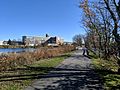
The Quequechan River Rail Trail, a path for walking and biking.

