Watuppa Ponds facts for kids
Quick facts for kids Watuppa Ponds |
|
|---|---|

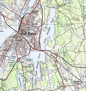
USGS map of Watuppa Ponds
|
|
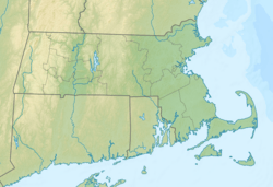
| Location | Fall River and Westport, Massachusetts |
| Coordinates | 41°41′00″N 71°07′00″W / 41.68333°N 71.11667°W |
| Type | natural |
| Primary inflows | Spring-fed, also Sucker Brook, Stony Brook, King Philip Brook, Queen Gutter Brook |
| Primary outflows | Quequechan River |
| Basin countries | United States |
| Max. length | 7.5 mi (12.1 km) (both ponds) |
| Max. width | 1.0 mi (1.6 km) (average) |
| Surface area | North 1,805 acres (730 ha) South 1,551 acres (628 ha) |
| Average depth | 15 ft (4.6 m) (South Watuppa) |
| Max. depth | 22 ft (6.7 m) (South Watuppa) 25 ft (7.6 m) (North Watuppa) |
| Surface elevation | 131 ft (40 m) |
| Sections/sub-basins | South Wattupa Pond, North Wattupa Pond |
The Watuppa Ponds are two big, natural ponds in Fall River and Westport, Massachusetts. They are fed by springs and were formed by glaciers long ago. The name Watuppa comes from a native word meaning "place of boats."
These two ponds used to be one large body of water. They were connected by a narrow, rocky area called "The Narrows." This area also helps mark the border between Fall River and Westport. Together, the ponds stretch about 7.5 miles from north to south. They are usually about a mile wide from east to west. The ponds drain into the Quequechan River, which flows west through Fall River. This river carries water from South Watuppa Pond all the way to Mount Hope Bay.
Discover the Watuppa Ponds
The Watuppa Ponds are split into two main parts: North Watuppa Pond and South Watuppa Pond. Each pond has its own unique features and uses.
North Watuppa Pond: A Drinking Water Source
North Watuppa Pond is the second-largest natural body of water in Massachusetts. It covers about 1,805 acres. This pond is about 4.2 miles long and usually about a mile wide. Its shoreline stretches for 12.4 miles. The deepest part of North Watuppa Pond is 25 feet.
Since 1873, this pond has been the main source of drinking water for the City of Fall River. Because it's used for drinking water, public access is very limited. Activities like fishing, boating, swimming, or ice skating are not allowed. City water department staff regularly patrol the area to keep the water clean and safe.
Water Flow and Protection
North Watuppa Pond flows into South Watuppa Pond through a small channel. This channel is located at the southern end of the pond, in the area known as The Narrows. The northeastern side of North Watuppa Pond is called Copicut Reservation. This area has lots of protected land. This helps keep the city's water supply clean.
Several small streams flow into North Watuppa Pond. These include King Philip Brook, Queen Gutter Brook, and Blossom Brook. A stone causeway crosses the north end of the pond. On the western side, there's a man-made canal. This canal helps direct stormwater runoff from the city away from North Watuppa Pond and into South Watuppa Pond.
South Watuppa Pond: A Place for Fun
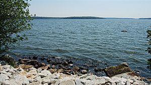
South Watuppa Pond is the third-largest natural body of water in Massachusetts. It covers about 1,551 acres. This pond is shaped a bit like a trumpet and is about 3.0 miles long. It's about 0.5 miles wide at its southern end and gets wider to about 1.5 miles at its northern end. There's also a large cove on the Westport side.
South Watuppa Pond has 10.4 miles of shoreline. It's usually about 15 feet deep, with a maximum depth of 22 feet. This pond gets its water from springs and streams. Sucker Brook flows into it from Stafford Pond in nearby Tiverton, Rhode Island. Stony Brook also feeds it from the south, bringing water from Sawdy Pond and Devol Pond.
Fishing and Recreation
South Watuppa Pond is a popular spot for fishing. There's a public boat ramp managed by the city at the end of Jefferson Street, near "Dave's Beach." Many types of fish live here, such as largemouth bass, smallmouth bass, tiger muskie, white perch, and black crappie.
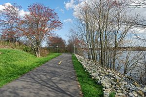
Besides fishing, people enjoy many other water sports on South Watuppa Pond. These include tubing, knee boarding, wake boarding, and water skiing. The old railroad bed along the pond has also been turned into a rail trail. This trail is great for walking, biking, and other activities.
History of the Watuppa Ponds
The Watuppa Ponds have an interesting past, with changes in borders and how people used the land around them.
Early Days and Border Changes
Before 1862, the border between Massachusetts and Rhode Island was different. Back then, all of South Watuppa Pond and the southern part of North Watuppa Pond were actually in Tiverton, Rhode Island.
Ice Houses and Estates
In the 1840s, several ice houses were built along the western shore of North Watuppa Pond. These buildings were used to store ice cut from the pond. The stone walls of one of these ice houses, built in 1864, can still be seen today. It's located on a small piece of land near New Boston Road. This area was once part of a large estate called Interlachen, owned by Spencer Borden. His estate had a big house, gardens, and horse paths. The city later bought this land to protect the water supply, and the house was taken down.
Travel and Transportation
Before 1872, small steam-boats would carry passengers from downtown Fall River to a picnic spot. This spot was called Adirondack Grove, located on the eastern shore of North Watuppa Pond in Westport.
In 1875, the Fall River Railroad was built. It ran along the north shore of South Watuppa Pond and crossed "The Narrows." This railroad connected New Bedford to the eastern part of Fall River. It carried goods until the early 1980s.
Roads and Highways
The road connecting Fall River with Westport became U.S. Route 6. It used to run along the southern edge of North Watuppa Pond. This created a small pond between the road and the railroad. This smaller pond became a popular place for fun, including ice skating in winter. The north shore of South Watuppa Pond also had many boat clubs and restaurants for years.
In the early 1950s, the Fall River Expressway was built along the western shore of North Watuppa Pond. This road, now known as Route 24, was later extended south. In 1963, Interstate 195 was built right through "The Narrows," separating the two ponds even more. Route 6 was then moved, and the small pond that was popular for ice skating was filled in.
Industry and Homes
Historically, many textile factories were located on the northern shores of South Watuppa Pond. These included the Fall River Bleachery and Kerr Thread Mills. Today, the eastern and southwestern shores of the pond are mostly surrounded by private homes. Public access to these areas is somewhat limited. Many of these homes were damaged during big floods in March 2010.
 | James Van Der Zee |
 | Alma Thomas |
 | Ellis Wilson |
 | Margaret Taylor-Burroughs |


