Henry County, Ohio facts for kids
Quick facts for kids
Henry County
|
|||
|---|---|---|---|

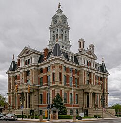
Henry County Courthouse
|
|||
|
|||

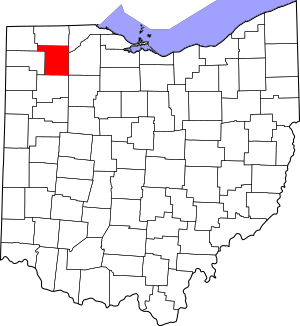
Location within the U.S. state of Ohio
|
|||
 Ohio's location within the U.S. |
|||
| Country | |||
| State | |||
| Founded | December 26, 1834 | ||
| Named for | Patrick Henry | ||
| Seat | Napoleon | ||
| Largest city | Napoleon | ||
| Area | |||
| • Total | 420 sq mi (1,100 km2) | ||
| • Land | 416 sq mi (1,080 km2) | ||
| • Water | 3.7 sq mi (10 km2) 0.9%% | ||
| Population
(2020)
|
|||
| • Total | 27,662 | ||
| • Density | 65.9/sq mi (25.43/km2) | ||
| Time zone | UTC−5 (Eastern) | ||
| • Summer (DST) | UTC−4 (EDT) | ||
| Congressional district | 5th | ||
Henry County is a county in the state of Ohio, United States. In 2020, about 27,662 people lived there. The main city and county seat is Napoleon.
Henry County was created in 1820 and officially started in 1834. It is named after Patrick Henry. He was an important American Founding Father. Patrick Henry is famous for his speech where he said, "give me liberty, or give me death!"
Contents
Geography of Henry County
Henry County covers a total area of about 420 square miles. Most of this area, about 416 square miles, is land. The rest, about 3.7 square miles, is water. This means only a small part (less than 1%) of the county is water.
Counties Nearby
Henry County shares its borders with several other counties:
- Fulton County (to the north)
- Lucas County (to the northeast)
- Wood County (to the east)
- Putnam County (to the south)
- Defiance County (to the west)
- Williams County (to the northwest)
- Hancock County (to the southeast)
People of Henry County
The number of people living in Henry County has changed over time. Here's a quick look at the population from different years:
| Historical population | |||
|---|---|---|---|
| Census | Pop. | %± | |
| 1830 | 262 | — | |
| 1840 | 2,503 | 855.3% | |
| 1850 | 3,434 | 37.2% | |
| 1860 | 8,901 | 159.2% | |
| 1870 | 14,028 | 57.6% | |
| 1880 | 20,585 | 46.7% | |
| 1890 | 25,080 | 21.8% | |
| 1900 | 27,282 | 8.8% | |
| 1910 | 25,119 | −7.9% | |
| 1920 | 23,362 | −7.0% | |
| 1930 | 22,524 | −3.6% | |
| 1940 | 22,756 | 1.0% | |
| 1950 | 22,423 | −1.5% | |
| 1960 | 25,392 | 13.2% | |
| 1970 | 27,058 | 6.6% | |
| 1980 | 28,383 | 4.9% | |
| 1990 | 29,108 | 2.6% | |
| 2000 | 29,210 | 0.4% | |
| 2010 | 28,215 | −3.4% | |
| 2020 | 27,662 | −2.0% | |
| U.S. Decennial Census 1790-1960 1900-1990 1990-2000 2020 |
|||
Population in 2010
In 2010, there were 28,215 people living in Henry County. These people lived in 10,934 households. About 7,883 of these were families.
Most people in the county were white (95.2%). A small number were Black or African American (0.4%), Asian (0.4%), or American Indian (0.3%). About 6.6% of the people were of Hispanic or Latino background.
Many people in Henry County have German roots (53.7%). Other common backgrounds include Irish (10.6%) and English (7.1%).
The average age of people in the county was about 39.8 years old.
Transportation
Henry County Airport
The Henry County Airport is an airport that anyone can use. It is located about 3 nautical miles (6 kilometers) east of Napoleon, Ohio. The Henry County Airport Authority owns and manages the airport.
Communities in Henry County
City
- Napoleon (This is the county seat, meaning it's where the county government is located.)
Villages
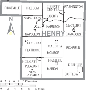
Townships
- Bartlow
- Damascus
- Flatrock
- Freedom
- Harrison
- Liberty
- Marion
- Monroe
- Napoleon
- Pleasant
- Richfield
- Ridgeville
- Washington
Census-Designated Place
- Ridgeville Corners (This is a special area that the Census Bureau defines for collecting data, but it's not an official city or village.)
Unincorporated Communities
These are small communities that are not officially part of a city or village.
See also
 In Spanish: Condado de Henry (Ohio) para niños
 | Jewel Prestage |
 | Ella Baker |
 | Fannie Lou Hamer |


