Defiance County, Ohio facts for kids
Quick facts for kids
Defiance County
|
|||
|---|---|---|---|

|
|||
|
|||

Location within the U.S. state of Ohio
|
|||
 Ohio's location within the U.S. |
|||
| Country | |||
| State | |||
| Founded | April 7, 1845 | ||
| Named for | Fort Defiance | ||
| Seat | Defiance | ||
| Largest city | Defiance | ||
| Area | |||
| • Total | 414 sq mi (1,070 km2) | ||
| • Land | 411 sq mi (1,060 km2) | ||
| • Water | 2.7 sq mi (7 km2) 0.7%% | ||
| Population
(2020)
|
|||
| • Total | 38,286 |
||
| • Density | 92/sq mi (36/km2) | ||
| Time zone | UTC−5 (Eastern) | ||
| • Summer (DST) | UTC−4 (EDT) | ||
| Congressional district | 9th | ||
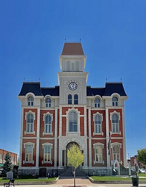
Defiance County is a special area called a county in the state of Ohio, USA. In 2020, about 38,286 people lived here. The biggest city and the place where the county government is located is Defiance.
The county got its name from an old army fort called Fort Defiance. A famous general named Mad Anthony Wayne named it to show that the early settlers were strong and wouldn't give up. Defiance County is also part of a larger area known as the Defiance Micropolitan Statistical Area.
Contents
Exploring Defiance County's Location
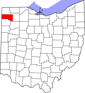
Defiance County is located in the northwest part of Ohio. It covers a total area of about 414 square miles. Most of this area, around 411 square miles, is land. The rest, about 2.7 square miles, is water.
Neighboring Counties Around Defiance
Defiance County shares its borders with several other counties. Knowing these helps you understand its place on a map!
- To the north is Williams County.
- To the east is Henry County.
- To the southeast is Putnam County.
- To the south is Paulding County.
- To the southwest is Allen County, Indiana.
- To the west is DeKalb County, Indiana.
People of Defiance County
The number of people living in Defiance County has changed over many years. Here's a quick look at how the population has grown and shifted since 1850:
| Historical population | |||
|---|---|---|---|
| Census | Pop. | %± | |
| 1850 | 6,966 | — | |
| 1860 | 11,886 | 70.6% | |
| 1870 | 15,719 | 32.2% | |
| 1880 | 22,515 | 43.2% | |
| 1890 | 25,769 | 14.5% | |
| 1900 | 26,387 | 2.4% | |
| 1910 | 24,498 | −7.2% | |
| 1920 | 24,549 | 0.2% | |
| 1930 | 22,714 | −7.5% | |
| 1940 | 24,367 | 7.3% | |
| 1950 | 25,925 | 6.4% | |
| 1960 | 31,508 | 21.5% | |
| 1970 | 36,949 | 17.3% | |
| 1980 | 39,987 | 8.2% | |
| 1990 | 39,350 | −1.6% | |
| 2000 | 39,500 | 0.4% | |
| 2010 | 39,037 | −1.2% | |
| 2020 | 38,286 | −1.9% | |
| U.S. Decennial Census 1790-1960 1900-1990 1990-2000 2020 |
|||
What the 2010 Census Showed
In 2010, there were 39,037 people living in Defiance County. There were 15,268 homes, and 10,792 families. Most people were white (92.8%). About 8.7% of the people were of Hispanic or Latino background. Many families living here had children under 18. The average age of people in the county was about 39.4 years old.
Towns and Villages in Defiance County
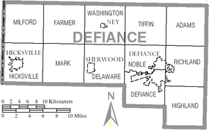
Defiance County has several communities, from its main city to smaller villages and townships.
The Main City
- Defiance (This is the county seat, where the main government offices are.)
Smaller Villages
Townships in the County
Townships are smaller local areas within the county.
- Adams
- Defiance
- Delaware
- Farmer
- Hicksville
- Highland
- Mark
- Milford
- Noble
- Richland
- Tiffin
- Washington
Unincorporated Communities
These are smaller places that are not officially cities or villages.
Learning in Defiance County
There are several school districts in Defiance County. These districts help make sure kids get a good education.
- Ayersville Local School District
- Central Local School District
- Defiance City School District
- Edgerton Local School District
- Hicksville Exempted Village School District
- Northeastern Local School District
See also
 In Spanish: Condado de Defiance para niños
 | DeHart Hubbard |
 | Wilma Rudolph |
 | Jesse Owens |
 | Jackie Joyner-Kersee |
 | Major Taylor |


