Paulding County, Ohio facts for kids
Quick facts for kids
Paulding County
|
|||
|---|---|---|---|

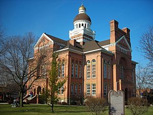
Courthouse in village of Paulding
|
|||
|
|||

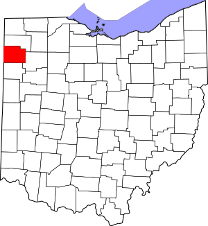
Location within the U.S. state of Ohio
|
|||
 Ohio's location within the U.S. |
|||
| Country | |||
| State | |||
| Founded | March 18, 1839 | ||
| Named for | John Paulding | ||
| Seat | Paulding | ||
| Largest village | Paulding | ||
| Area | |||
| • Total | 419 sq mi (1,090 km2) | ||
| • Land | 416 sq mi (1,080 km2) | ||
| • Water | 2.4 sq mi (6 km2) 0.6%% | ||
| Population
(2020)
|
|||
| • Total | 18,806 |
||
| • Density | 45/sq mi (17/km2) | ||
| Time zone | UTC−5 (Eastern) | ||
| • Summer (DST) | UTC−4 (EDT) | ||
| Congressional district | 5th | ||
Paulding County is a county in Ohio, a state in the United States. In 2020, about 18,806 people lived here. The main town and county seat is Paulding.
The county was first created in 1820. It was officially organized in 1839. Paulding County is named after John Paulding. He was a hero in the American Revolutionary War. He helped capture a British spy named Major John André.
Contents
History of Paulding County
Early Native American Life
Long ago, the Ottawa tribe lived in this area. Many other Native American tribes also lived here. These included the Miamis, Shawnee, and Wyandotts. They lived here before Europeans arrived in North America.
Settlement and Conflicts
After the American Revolution, the U.S. government opened new lands for settlement. This included what is now Ohio. But British soldiers stayed in the area. They caused problems with the Native American tribes.
General Anthony Wayne was sent to help. He built forts to protect settlers. One fort, Fort Brown, was near Charloe and Melrose. He also cleared a wide path through the woods. This path was called the Wayne Trace. It helped protect his soldiers.
In 1794, General Wayne's army fought a big battle. It was called the Battle of Fallen Timbers. His army won against Native American tribes. This led to the Treaty of Greenville in 1795. This treaty helped make the area safer for settlers.
Forming the County
Paulding County was first part of lands set aside for Native Americans. But this changed over time. The county was officially formed on April 1, 1820. It was created from parts of Williams County.
Later, in 1845, Defiance County was formed. This changed Paulding County's borders. Some land from Paulding County became part of Defiance County.
Life in Early Paulding County
Life was hard for early settlers. The land was very wet and swampy. Farmers joked they grew "frogs and ice." Many people got sick with a disease called "ague." We now know this was malaria.
The area had thick forests. Trees were a big business. Large timbers were floated down the Maumee River. They were used to make masts for ships. Some trees were so huge that a man could live inside a hollow one!
Canals and Transportation
In the early 1800s, canals were very important. They helped move goods and people. The Erie Canal opened in 1825. This led to more canals being built.
Two big canals ran through Paulding County. These were the Miami and Erie Canal and the Wabash and Erie Canal. They connected Lake Erie to other parts of Ohio and Indiana. The canals made Paulding County a busy place. Many workers came to build them. In 1835, the county's population grew to 25,000 people. This was more than it has ever been since!
The canal system was the largest in the world. But it was only profitable for a short time. Canals froze in winter. Their banks often collapsed. Boats had to move very slowly. Soon, railroads became popular. Trains were much faster and more reliable. The canals were slowly abandoned.
One interesting leftover from the canal era is the Furnace Farm near Cecil. Iron ore was brought there by canal. It was turned into iron using local fuel. One furnace still stands. It was left to cool with iron inside. There was no way to ship the iron cheaply after the canals closed.
Paulding County Carnegie Library
The Paulding County Carnegie Library was built in the 1910s. It was special because it was the first Carnegie library to serve a whole county. Most Carnegie libraries served only one city.
Andrew Carnegie was a rich businessman. He also helped pay for a pipe organ. This organ is in what is now Paulding United Methodist Church.
A Mysterious Past
In the early 1900s, Paulding County had a strange problem. It had many unsolved murders. Some people thought a gang called the Purple Gang was involved. They believed the gang brought bodies from other places to dump them in the quiet countryside. The sheriff at the time said these victims were not from Paulding County. He felt it was not worth a lot of local money to investigate what he saw as a "littering problem."
Geography
Paulding County covers about 419 square miles. Most of it, about 416 square miles, is land. Only a small part, about 2.4 square miles, is water.
The county is very flat. The center of the county is 723 feet above sea level. The land does not change much in height. Roads often form a checkerboard pattern. This flat land means Paulding County is entirely within the Great Black Swamp.
Major roads like U.S. Route 127, U.S. Route 24, and U.S. Route 30 (the Lincoln Highway) cross the county. Two main rivers flow through: the Auglaize and the Maumee. There are also many small creeks. The biggest bodies of water are man-made ponds.
Neighboring Counties
- Defiance County (north)
- Putnam County (east)
- Van Wert County (south)
- Allen County, Indiana (west)
Population Information
| Historical population | |||
|---|---|---|---|
| Census | Pop. | %± | |
| 1830 | 161 | — | |
| 1840 | 1,034 | 542.2% | |
| 1850 | 1,766 | 70.8% | |
| 1860 | 4,945 | 180.0% | |
| 1870 | 8,544 | 72.8% | |
| 1880 | 13,485 | 57.8% | |
| 1890 | 25,932 | 92.3% | |
| 1900 | 27,528 | 6.2% | |
| 1910 | 22,730 | −17.4% | |
| 1920 | 18,736 | −17.6% | |
| 1930 | 15,301 | −18.3% | |
| 1940 | 15,527 | 1.5% | |
| 1950 | 15,047 | −3.1% | |
| 1960 | 16,792 | 11.6% | |
| 1970 | 19,329 | 15.1% | |
| 1980 | 21,302 | 10.2% | |
| 1990 | 20,488 | −3.8% | |
| 2000 | 20,293 | −1.0% | |
| 2010 | 19,614 | −3.3% | |
| 2020 | 18,806 | −4.1% | |
| U.S. Decennial Census 1790-1960 1900-1990 1990-2000 2020 |
|||
2010 Census Data
In 2010, Paulding County had 19,614 people. There were 7,769 households. The population density was about 47 people per square mile.
Most people in the county were white (95.7%). About 0.9% were Black or African American. About 0.3% were American Indian. People of Hispanic or Latino origin made up 4.3% of the population.
Many families lived in the county. About 32.5% of households had children under 18. Most households (56.1%) were married couples. The average age of people in the county was 40 years old.
Education
In 1971, some school districts in Paulding County merged. Payne, Blue Creek, and Grover Hill schools joined together. They formed the Wayne Trace school district. Auglaize-Brown schools joined Paulding Exempted Village Schools.
Here are the school districts in Paulding County:
- Antwerp Local School District
- Paulding Exempted Village School District
- Wayne Trace Local School District
- Vantage Career Center
In the late 1950s, Paulding Exempted Village Schools started a special tax plan. It was called "pay-as-you-go." This meant they paid for new school buildings with cash. This helped save money by avoiding high interest on loans. Other local governments in Ohio have used this idea too.
The Paulding campus of PEVS is very large. It has students from kindergarten all the way to high school in one place. It is one of the biggest schools in Ohio.
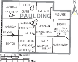
Communities
Villages
Townships
- Auglaize
- Benton
- Blue Creek
- Brown
- Carryall
- Crane
- Emerald
- Harrison
- Jackson
- Latty
- Paulding
- Washington
Unincorporated Communities
Interesting Facts
County Motto
Paulding County's motto is "No Compromise." This came from a banner used during the Reservoir War. This was a disagreement over water rights.
Carnegie's Gifts
Paulding County was the first county in the U.S. to get money from Andrew Carnegie for a library. He also helped pay for a pipe organ. This organ is in the Paulding Methodist Church.
A Name Change
Judge Calvin L. Noble lived in Paulding County for most of his life. He is famous for changing the name of the city of Cleaveland, Ohio, to Cleveland. When he was a printer, he started a newspaper called the Cleaveland Advertiser. The name was too long to fit on the page. So, he simply left out one letter!
Healthcare Access
For a while, Paulding County was the only county in the U.S. without certain healthcare plans. These plans were offered through the government's health insurance exchange. But in August 2017, a company called CareSources started offering plans there.
See also
 In Spanish: Condado de Paulding (Ohio) para niños
 | James B. Knighten |
 | Azellia White |
 | Willa Brown |


