Van Wert County, Ohio facts for kids
Quick facts for kids
Van Wert County
|
|||
|---|---|---|---|

|
|||
|
|||

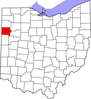
Location within the U.S. state of Ohio
|
|||
 Ohio's location within the U.S. |
|||
| Country | |||
| State | |||
| Founded | February 12, 1820 | ||
| Named for | Isaac Van Wart | ||
| Seat | Van Wert | ||
| Largest city | Van Wert | ||
| Area | |||
| • Total | 410 sq mi (1,100 km2) | ||
| • Land | 409 sq mi (1,060 km2) | ||
| • Water | 1.3 sq mi (3 km2) 0.3%% | ||
| Population
(2020)
|
|||
| • Total | 28,931 |
||
| • Density | 71/sq mi (27/km2) | ||
| Time zone | UTC−5 (Eastern) | ||
| • Summer (DST) | UTC−4 (EDT) | ||
| Congressional district | 5th | ||
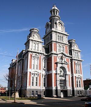
Van Wert County is a special area in the state of Ohio, United States. It is like a local government division. As of 2020, about 28,931 people live here. The main town and government center is Van Wert.
This county was created on February 12, 1820. It was officially organized on March 18, 1837. Van Wert County is named after Isaac Van Wart. He was a hero in the American Revolutionary War. He helped capture a British spy named John André.
Contents
Exploring Van Wert County: Geography
Van Wert County covers a total area of 410 square miles. Most of this area, about 409 square miles, is land. Only a small part, about 1.3 square miles, is water. This means it is mostly land with very little water.
Neighboring Areas: Adjacent Counties
Van Wert County shares its borders with several other counties. These are like its neighbors.
- Paulding County (to the north)
- Putnam County (to the northeast)
- Allen County, Ohio (to the east)
- Auglaize County (to the southeast)
- Mercer County (to the south)
- Adams County, Indiana (to the southwest)
- Allen County, Indiana (to the northwest)
It is interesting that Van Wert County borders two counties named Allen County. One is in Ohio, and the other is in Indiana. This is quite rare in the United States!
Who Lives Here: Population and People
The number of people living in Van Wert County has changed over many years. Here is how the population has grown:
| Historical population | |||
|---|---|---|---|
| Census | Pop. | %± | |
| 1830 | 49 | — | |
| 1840 | 1,577 | 3,118.4% | |
| 1850 | 4,793 | 203.9% | |
| 1860 | 10,238 | 113.6% | |
| 1870 | 15,823 | 54.6% | |
| 1880 | 23,028 | 45.5% | |
| 1890 | 29,671 | 28.8% | |
| 1900 | 30,394 | 2.4% | |
| 1910 | 29,119 | −4.2% | |
| 1920 | 28,210 | −3.1% | |
| 1930 | 26,273 | −6.9% | |
| 1940 | 26,759 | 1.8% | |
| 1950 | 26,971 | 0.8% | |
| 1960 | 28,840 | 6.9% | |
| 1970 | 29,194 | 1.2% | |
| 1980 | 30,458 | 4.3% | |
| 1990 | 30,464 | 0.0% | |
| 2000 | 29,659 | −2.6% | |
| 2010 | 28,744 | −3.1% | |
| 2020 | 28,931 | 0.7% | |
| U.S. Decennial Census 1790-1960 1900-1990 1990-2000 2020 |
|||
A Look at the 2010 Census
In 2010, there were 28,744 people living in Van Wert County. There were 11,439 households, which are groups of people living together. The population density was about 70 people per square mile.
Most people in the county were white, making up 96.6% of the population. Other groups included Black or African American people (0.9%), Asian people (0.2%), and American Indian people (0.1%). About 2.6% of the population was of Hispanic or Latino origin.
Many families in the county have German roots (43.6%). Other common backgrounds include Irish (12.4%), English (11.5%), and American (11.0%). The average age of people in the county was about 40 years old.
Places to Live: Communities in Van Wert County
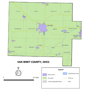
Van Wert County has different types of communities. These include cities, villages, and townships.
Cities in the County
- Delphos (only part of this city is in Van Wert County)
- Van Wert (this is the main city and county seat)
Villages in the County
Townships in the County
Townships are smaller areas within the county. They often have their own local governments.
- Harrison
- Hoaglin
- Jackson
- Jennings
- Liberty
- Pleasant
- Ridge
- Tully
- Union
- Washington
- Willshire
- York
Smaller Unincorporated Communities
These are smaller places that are not officially cities or villages.
- Abanaka
- Cavett
- Dixon‡
- Dull
- Glenmore
- Hoaglin
- Jonestown
- Middlebury
- Monticello
- Schumm
- Seamersville
See also
 In Spanish: Condado de Van Wert para niños
 | Emma Amos |
 | Edward Mitchell Bannister |
 | Larry D. Alexander |
 | Ernie Barnes |


