Mercer County, Ohio facts for kids
Quick facts for kids
Mercer County
|
|||
|---|---|---|---|
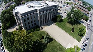
Mercer County courthouse
|
|||
|
|||
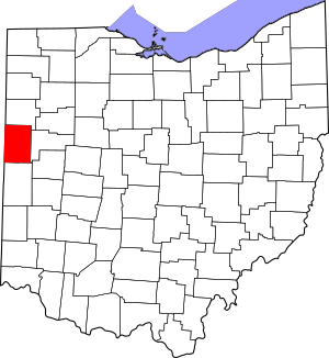
Location within the U.S. state of Ohio
|
|||
 Ohio's location within the U.S. |
|||
| Country | |||
| State | |||
| Founded | January 2, 1824 | ||
| Named for | Hugh Mercer | ||
| Seat | Celina | ||
| Largest city | Celina | ||
| Area | |||
| • Total | 473 sq mi (1,230 km2) | ||
| • Land | 462 sq mi (1,200 km2) | ||
| • Water | 11 sq mi (30 km2) 2.3%% | ||
| Population
(2020)
|
|||
| • Total | 42,528 |
||
| • Density | 90/sq mi (30/km2) | ||
| Time zone | UTC−5 (Eastern) | ||
| • Summer (DST) | UTC−4 (EDT) | ||
| Congressional district | 5th | ||
Mercer County is a county located in the U.S. state of Ohio. In 2020, about 42,528 people lived there. The main town and county seat (where the county government is) is Celina.
The county was created in 1820 and officially organized in 1824. It is named after Hugh Mercer. He was an important officer in the American Revolutionary War. Mercer County is also part of the Celina Micropolitan Statistical Area. This means Celina and the surrounding areas are closely connected.
Contents
History of Mercer County
Mercer County was formed in 1820 from parts of Darke and Shelby counties. Some land south of the Greenville Treaty Line was still part of Darke County. Mercer County officially became a county on January 2, 1824.
In 1837, Van Wert County was separated from Mercer County. This created Mercer County's current northern border. In 1839, Celina became the county seat. Before that, St. Marys was the county seat.
In 1848, the area south of the Greenville Treaty Line was added to Mercer County. When Auglaize County was formed, Mercer County's eastern border moved west. This created the sharp point at Mercer County's southeast corner. This was the last time the county lines changed.
In the mid to late 1800s, many German immigrant farming families moved to Mercer County. Most of these German Americans came from northwestern Germany.
Geography of Mercer County
Mercer County covers about 473 square miles. Of this, 462 square miles are land and 11 square miles (2.3%) are water. The county's elevation changes by less than 300 feet.
The highest point is 1,071 feet above sea level. This is on the southern county line, near where the Wabash River begins. The lowest point is 780 feet above sea level. This is on the northern county line, where the St. Marys River crosses.
Rivers and Water Basins
Mercer County has two main rivers: the Wabash River and the St. Marys River. The Wabash River's water flows into the Gulf of Mexico. The St. Marys River's water flows into Lake Erie. In some places, the creeks that feed these two rivers are less than a mile apart. The line that divides these two water systems is called the St. Lawrence Continental Divide.
Beaver Creek
Beaver Creek is the longest and largest creek in Mercer County. It is 19.7 miles long and has two parts. The first part starts in the southern farmlands. It flows through Montezuma, Ohio and into Grand Lake St. Marys. The second part of the creek starts as a spillway (a channel for water to flow over) and empties into the Wabash River.
Beaver Creek used to be one continuous creek. But it was split into two sections when Grand Lake was built. The creek's spillway has caused some problems. Farmers along Beaver Creek say their land floods because of a new spillway built in 1997. The old spillway was built in 1913.
Neighboring Counties
Mercer County shares borders with these counties:
- Adams County, Indiana (northwest)
- Van Wert County (north)
- Auglaize County (east)
- Shelby County (southeast)
- Darke County (south)
- Jay County, Indiana (southwest)
Population of Mercer County
| Historical population | |||
|---|---|---|---|
| Census | Pop. | %± | |
| 1820 | 95 | — | |
| 1830 | 1,110 | 1,068.4% | |
| 1840 | 8,277 | 645.7% | |
| 1850 | 7,712 | −6.8% | |
| 1860 | 14,104 | 82.9% | |
| 1870 | 17,254 | 22.3% | |
| 1880 | 21,808 | 26.4% | |
| 1890 | 27,220 | 24.8% | |
| 1900 | 28,021 | 2.9% | |
| 1910 | 27,536 | −1.7% | |
| 1920 | 26,872 | −2.4% | |
| 1930 | 25,096 | −6.6% | |
| 1940 | 26,256 | 4.6% | |
| 1950 | 28,311 | 7.8% | |
| 1960 | 32,559 | 15.0% | |
| 1970 | 35,265 | 8.3% | |
| 1980 | 38,334 | 8.7% | |
| 1990 | 39,443 | 2.9% | |
| 2000 | 40,924 | 3.8% | |
| 2010 | 40,814 | −0.3% | |
| 2020 | 42,528 | 4.2% | |
| U.S. Decennial Census | |||
In 2010, there were 40,814 people living in Mercer County. Most people (97.4%) were white. About 58.7% of the people had German ancestry. The average age was about 39.4 years old.
The average income for a household was $49,719. About 8.3% of the people in the county lived below the poverty line.
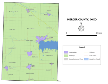
Communities in Mercer County
City
- Celina (county seat)
Villages
Townships
- Black Creek
- Butler
- Center
- Dublin
- Franklin
- Gibson
- Granville
- Hopewell
- Jefferson
- Liberty
- Marion
- Recovery
- Union
- Washington
- Wayne (no longer exists, now part of Celina)
Unincorporated Communities
These are smaller communities that are not officially cities or villages.
- Carthagena
- Cassella
- Chattanooga
- Cranberry Prairie
- Erastus
- Macedon
- Maria Stein
- Mercer
- Padua
- Sebastian
See also
 In Spanish: Condado de Mercer (Ohio) para niños
 | Audre Lorde |
 | John Berry Meachum |
 | Ferdinand Lee Barnett |


