Fort Recovery, Ohio facts for kids
Quick facts for kids
Fort Recovery, Ohio
|
|
|---|---|
|
Village
|
|

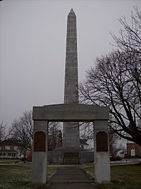
Victory monument in Fort Recovery
|
|

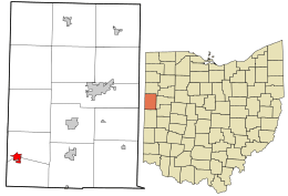
Location of Fort Recovery in Mercer County and of Mercer County in Ohio
|
|
| Country | United States |
| State | Ohio |
| County | Mercer |
| Townships | Gibson and Recovery |
| Area | |
| • Total | 1.25 sq mi (3.25 km2) |
| • Land | 1.23 sq mi (3.20 km2) |
| • Water | 0.02 sq mi (0.05 km2) |
| Elevation | 942 ft (287 m) |
| Population
(2020)
|
|
| • Total | 1,501 |
| • Estimate
(2023)
|
1,476 |
| • Density | 1,216.37/sq mi (469.74/km2) |
| Time zone | UTC-5 (Eastern (EST)) |
| • Summer (DST) | UTC-4 (EDT) |
| ZIP Code |
45846
|
| Area code(s) | 419 |
| FIPS code | 39-27902 |
| GNIS feature ID | 2398904 |
| Website | http://www.fortrecovery.org/ |
Fort Recovery is a small village in Mercer County, Ohio, in the United States. In 2020, about 1,501 people lived there. The village is named after Fort Recovery, a historic fort built in 1793. This fort was ordered by General Anthony Wayne. The village is also close to where the Wabash River begins.
Contents
History of Fort Recovery
Fort Recovery is famous for two important battles. These battles happened during the Northwest Indian War. At that time, Native American nations lived in and claimed the Ohio area. Conflicts started when the United States began to settle lands north of the Ohio River.
Major Battles and the Fort's Creation
In 1791, Northwest Territory governor Arthur St. Clair led an army. They marched north from Fort Washington. Their goal was to make peace with the Western Confederacy at Kekionga. Instead, on November 4, the United States army was badly defeated. This event is known as St. Clair's Defeat. It was the biggest loss the U.S. Army ever had against a Native American force.
Because of this big loss, a new army was formed. It was called the Legion of the United States. General "Mad Anthony" Wayne was put in charge. In late 1793, Wayne led 300 soldiers to the site of St. Clair's defeat. He decided to build a fort there, which he named Fort Recovery. On December 25, they found the site because there were many unburied remains. A soldier named George Will wrote that they had to move bones to set up their beds.
The Siege of Fort Recovery
On June 30 of the next year, a large Native American force attacked the fort. A few British officers were with them. This event was called the Siege of Fort Recovery. The Legion lost many soldiers. However, they managed to keep control of the fort. This was partly because they had found cannons that St. Clair's army had lost in 1791.
General Wayne used Fort Recovery as a base. From there, he moved deeper into the territory. He finally defeated the Native American confederacy. This happened at the Battle of Fallen Timbers in August 1794. In 1795, Native American leaders signed the Treaty of Greenville. This treaty gave control of most of modern Ohio to the United States. Fort Recovery was used as a key point for the border.
Hidden Treasure and Bone Burying Day
In 1818, a soldier from Virginia returned to the area. He had fought in St. Clair's Defeat. He was looking for silver he had left near an oak tree. The soldier stayed for some time. Later, he was found dead in the woods.
In 1852, a local person found metal while digging. It was iron bands around a small wooden box. Inside, they found 900 Spanish doubloons. These gold coins were worth a lot of money back then.
In September 1851, the town held a special event. It was called Bone Burying Day. On this day, they buried the many bones found from the battles.
Geography of Fort Recovery
Fort Recovery is located at 40°24′44″N 84°46′40″W / 40.412156°N 84.777641°W. The United States Census Bureau says Fort Recovery covers about 1.07 square miles (2.77 square kilometers). Most of this area is land, with a small part being water.
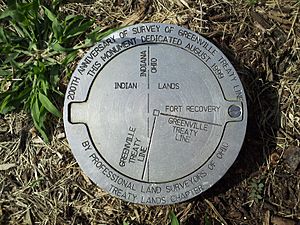
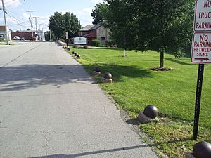
The northwest corner of the Greenville Treaty Line is located in Fort Recovery. This line was important for marking borders.
Fort Recovery is a meeting point for several main roads. These include State Route 119 and State Route 49. The Wabash River also flows through the village. Fort Recovery was once a stop on the New York, Chicago, and St. Louis Railroad. This railway connected big cities like Buffalo and Chicago.
Population and People
| Historical population | |||
|---|---|---|---|
| Census | Pop. | %± | |
| 1870 | 89 | — | |
| 1880 | 102 | 14.6% | |
| 1890 | 456 | 347.1% | |
| 1900 | 698 | 53.1% | |
| 1910 | 708 | 1.4% | |
| 1920 | 754 | 6.5% | |
| 1930 | 796 | 5.6% | |
| 1940 | 822 | 3.3% | |
| 1950 | 827 | 0.6% | |
| 1960 | 833 | 0.7% | |
| 1970 | 847 | 1.7% | |
| 1980 | 859 | 1.4% | |
| 1990 | 901 | 4.9% | |
| 2000 | 1,006 | 11.7% | |
| 2010 | 1,430 | 42.1% | |
| 2020 | 1,501 | 5.0% | |
| 2023 (est.) | 1,476 | 3.2% | |
| U.S. Decennial Census | |||
The population of Fort Recovery has grown over the years. In 2010, there were 1,430 people living in the village. About 555 households were counted. The average household had about 2.58 people.
The median age in the village in 2010 was 34.8 years old. About 28.2% of the people were under 18 years old. About 14.7% were 65 years or older.
Notable People from Fort Recovery
- Richard Butler: A general who died at St. Clair's defeat. He is buried at Fort Recovery.
- Rick Derringer: A famous guitarist, singer, and entertainer. He is known for his song "Real American."
- Richard Schoen: An award-winning mathematician. He works at the University of California, Irvine.
- Henry H. Schwartz: He was a U.S. Senator from Wyoming.
See also
 In Spanish: Fort Recovery (Ohio) para niños
 | Sharif Bey |
 | Hale Woodruff |
 | Richmond Barthé |
 | Purvis Young |


