Wabash River facts for kids
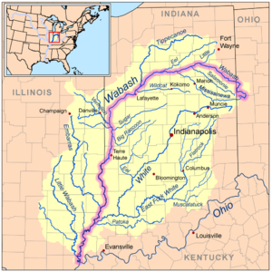
The Wabash River is a long and important river in the Midwestern United States. It flows for about 503 miles (810 kilometers). The river starts in northwest Ohio, near a town called Fort Recovery. From there, it travels southwest through northern Indiana and then into southern Illinois.
The Wabash River forms part of the border between Illinois and Indiana. It eventually flows into the Ohio River. The Wabash is the biggest river that joins the Ohio River from the north. For a long stretch, about 411 miles (661 kilometers), the Wabash River flows freely without any dams, from near Huntington, Indiana all the way to the Ohio River.
Contents
About the Wabash River
The Wabash River has been very important throughout history. It helped people travel and trade. Native American tribes lived along its banks for thousands of years. Later, explorers and settlers used the river to move across the land.
Where Does the Wabash River Flow?
The journey of the Wabash River begins in Ohio. It then crosses the entire state of Indiana. This makes it a central part of Indiana's geography. As it reaches the end of its path, it helps create the border with Illinois. Finally, it empties into the mighty Ohio River.
What Makes the Wabash River Special?
One cool fact about the Wabash River is how much of it flows freely. This means there are no large dams blocking its path for hundreds of miles. This natural flow helps keep the river's ecosystem healthy. It also makes it a great place for different kinds of plants and animals to live. Many people enjoy fishing, boating, and exploring the areas around the Wabash River.
Images for kids
-
A scene along the Wabash River, sketched in 1778 by Lt Governor Henry Hamilton
-
The Wabash River at Covington, Indiana
-
A small island and water fowl wildlife refuge in the Wabash near Mount Carmel, Illinois
-
Wabash River in Limberlost Recreation Area, south of Berne, Indiana.
-
Lincoln Memorial Bridge over the Wabash River near the George Rogers Clark National Historical Park
See also
 In Spanish: Río Wabash para niños
 | Sharif Bey |
 | Hale Woodruff |
 | Richmond Barthé |
 | Purvis Young |


