
St. Marys, Ohio facts for kids
Quick facts for kids
St. Marys, Ohio
|
|||
|---|---|---|---|

Fountain Hotel, Downtown St. Marys
|
|||
|
|||
| Nickname(s):
Ridertown
|
|||
| Motto(s):
Where living is a pleasure
|
|||

Location of St. Marys in Auglaize County
|
|||

St. Marys, Ohio
Location in Ohio

St. Marys, Ohio
Location in the United States
|
|||
| Country | United States | ||
| State | Ohio | ||
| County | Auglaize | ||
| incorporated | 1834 | ||
| Area | |||
| • Total | 4.70 sq mi (12.17 km2) | ||
| • Land | 4.67 sq mi (12.09 km2) | ||
| • Water | 0.03 sq mi (0.08 km2) | ||
| Elevation | 869 ft (265 m) | ||
| Population
(2020)
|
|||
| • Total | 8,397 | ||
| • Density | 1,798.84/sq mi (694.56/km2) | ||
| census | |||
| Time zone | UTC-4 (EST) | ||
| • Summer (DST) | UTC-4 (EDT) | ||
| ZIP code |
45885
|
||
| Area code(s) | 419 | ||
| FIPS code | 39-69680 | ||
| GNIS feature ID | 2396505 | ||
| Website | www.cityofstmarys.net | ||


St. Marys is a city located in Auglaize County, Ohio, in the United States. It's in western Ohio, about 11 miles west of Wapakoneta. The city was founded in 1823. St. Marys is special because it's built on a "portage" – a place where people could easily carry boats and goods between the St. Marys River and the Auglaize River. This was very important for travel and trade a long time ago, before canals were built. In 2020, about 8,397 people lived in St. Marys.
Contents
History of St. Marys
Early Settlements and Forts
Before St. Marys became a city, it was a Native American village. It was sometimes known as Girty's Town, named after traders James and Simon Girty. They had a trading post there.
In 1794, after a big battle, General Anthony Wayne passed through the St. Marys area. He noticed how important the location was because it connected two rivers. He ordered a fort to be built there. This fort, named Fort St. Mary's after the nearby river, was finished in 1795.
Later, in 1812, another fort called Fort Barbee was built nearby.
Important Treaties and City Growth
St. Marys was the place where important agreements were signed. These included the Treaty of St. Mary's of 1818. This treaty helped the United States gain a large area of land in Indiana from the Miami and Delaware Indians. After these treaties, the fort was no longer needed.
The first settlers arrived in 1820. St. Marys was officially founded in 1823 by William Houston, John McCorkle, and Charles Murray. They bought land and planned out the village. St. Marys became an official town in 1834, and Judge Stacy Taylor was its first mayor. It grew into a city in 1904 when its population passed 5,000 people.
For a while, St. Marys was the main town, or county seat, for Mercer County from 1824 to 1840. When Auglaize County was formed in 1848, St. Marys tried to become its county seat but was not chosen.
Historic Places and Green Initiatives
Several places in St. Marys are listed on the National Register of Historic Places. These include the old Fountain Hotel and the Dr. Issac Elmer Williams House and Office.
St. Marys is also part of the Tree City USA program. This means the city works to plant and care for trees, making it a greener place to live.
Geography
St. Marys covers a total area of about 4.62 square miles (12.0 square kilometers). Most of this area is land, with a small part being water.
Education
Students in St. Marys attend Memorial High School.
Population Information
| Historical population | |||
|---|---|---|---|
| Census | Pop. | %± | |
| 1840 | 92 | — | |
| 1850 | 873 | 848.9% | |
| 1860 | 1,154 | 32.2% | |
| 1870 | 1,370 | 18.7% | |
| 1880 | 1,745 | 27.4% | |
| 1890 | 3,000 | 71.9% | |
| 1900 | 5,359 | 78.6% | |
| 1910 | 5,732 | 7.0% | |
| 1920 | 5,679 | −0.9% | |
| 1930 | 5,433 | −4.3% | |
| 1940 | 5,532 | 1.8% | |
| 1950 | 6,206 | 12.2% | |
| 1960 | 7,737 | 24.7% | |
| 1970 | 7,699 | −0.5% | |
| 1980 | 8,414 | 9.3% | |
| 1990 | 8,441 | 0.3% | |
| 2000 | 8,342 | −1.2% | |
| 2010 | 8,332 | −0.1% | |
| 2020 | 8,397 | 0.8% | |
| 2021 (est.) | 8,411 | 0.9% | |
| Sources: | |||
2010 Census Details
In 2010, the city had 8,332 people living in 3,283 households. About 33.9% of these households had children under 18. Many households (49.7%) were married couples living together.
The average age of people in St. Marys was 37.5 years old. About 26.6% of residents were under 18, and 14.4% were 65 or older. The population was almost evenly split between males (49.2%) and females (50.8%).
Sister Cities
St. Marys has special connections with two cities in other countries:
 - Awaji, Japan
 - Lienen, Nordrhein-Westfalen, Germany
It's interesting that St. Marys' neighbors, Wapakoneta and New Knoxville, are also sister cities with towns near Lienen in Germany.
Notable People
Many interesting people have come from St. Marys, including:
- Galen Cisco, a professional baseball player and coach.
- William K. Howard, a film director.
- Barbara Poppe, who worked for the U.S. government to help people experiencing homelessness.
- Jim Tully, an author.
- Robert Vogel, a professional marksman.
- Chuck Weyant, a racecar driver.
- Johann August Ernst von Willich, a military officer and general during the American Civil War.
Gallery
-
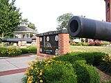
Memorial wall and twin cannons at Memorial Park in St. Marys, Ohio.
-
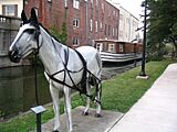
Canal boat exhibit at Memorial Park. Display features a life-sized metal horse tethered to a restored canal boat on the Miami-Erie Canal.
-
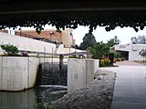
The recently restored Lock 13 in St. Marys, Ohio. Lock 13 is one of many locks along the Miami-Erie Canal.
-
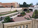
The newly restored Lock 13 area in the middle of downtown St. Marys.
-

Beginning of the Carl Chiles Walk Path near Lock 13 and Memorial Park in St. Marys. This path runs along the Miami-Erie Canal.


See also
 In Spanish: St. Marys (Ohio) para niños
