Auglaize River facts for kids
Quick facts for kids Auglaize River |
|
|---|---|

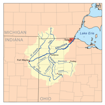
Map of the Maumee River watershed showing the Auglaize River.
|
|
| Physical characteristics | |
| Main source | 2 mi (3.2 km) south of Harrod ≈990 ft (300 m) |
| River mouth | Maumee River at Defiance ≈665 ft (203 m) |
| Length | 113 miles (182 km) |
| Basin features | |
| Basin size | 2,337 sq mi (6,050 km2) |

The Auglaize River (called Kathinakithiipi by the Shawnee people) is a river in northwestern Ohio, United States. It is about 113-mile-long (182 km) and flows into the Maumee River. This river helps drain a large area of farmland that eventually leads to Lake Erie.
The name "Auglaize" comes from a French term. The French explorers called it "rivière à la Grande Glaize" which means "river of Great Clay." This name describes the clay-rich soil found in the area around the river.
Contents
Where Does the Auglaize River Start and End?
The Auglaize River begins in southeastern Allen County. This is about 10 miles (16 km) southeast of Lima. From there, it flows southwest towards Wapakoneta.
After Wapakoneta, the river generally flows north. It takes a winding, zigzag path through towns like Delphos, Fort Jennings, and Oakwood. Finally, the Auglaize River joins the larger Maumee River from the south at Defiance.
Other Rivers Joining the Auglaize
Several smaller rivers and creeks flow into the Auglaize River along its journey:
- The Ottawa River joins it from the southeast in western Putnam County.
- The Blanchard River also flows into it in western Putnam County.
- The Little Auglaize River joins from the south in eastern Paulding County.
- Flatrock Creek flows into it from the west in northeastern Paulding County.
A Look at the Auglaize River's History
In the 1700s, the land around the Auglaize River was home to the Ottawa people. This area became an important center for Native American groups in the mid-1790s.
Later, during the War of 1812, two important forts were built along the river:
- Fort Defiance was built in 1794 by General Mad Anthony Wayne. It was located where the Auglaize and Maumee rivers meet.
- Fort Amanda was built in 1812 southwest of Lima. It served as a key outpost for American forces during the war.
Other Names for the Auglaize River
Over time, the Auglaize River has been known by several different names. Here are some of them:
- Au Glaize River
- Auglaise River
- Cowthenake sepe
- Glaize River
- Grand Au Glaze River
- Grand Glaise River
- Grand Glaize River
- Great au Glaise River
- Qusquasrundee
See Also
 | Georgia Louise Harris Brown |
 | Julian Abele |
 | Norma Merrick Sklarek |
 | William Sidney Pittman |

