Putnam County, Ohio facts for kids
Quick facts for kids
Putnam County
|
|||
|---|---|---|---|

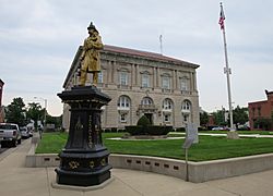
Putnam County Courthouse
|
|||
|
|||

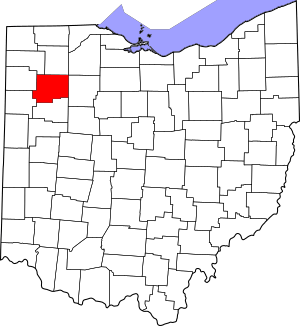
Location within the U.S. state of Ohio
|
|||
 Ohio's location within the U.S. |
|||
| Country | |||
| State | |||
| Founded | January 3, 1834 | ||
| Named for | Israel Putnam | ||
| Seat | Ottawa | ||
| Largest village | Ottawa | ||
| Area | |||
| • Total | 484 sq mi (1,250 km2) | ||
| • Land | 483 sq mi (1,250 km2) | ||
| • Water | 1.8 sq mi (5 km2) 0.4%% | ||
| Population
(2020)
|
|||
| • Total | 34,451 |
||
| • Density | 71/sq mi (27/km2) | ||
| Time zone | UTC−5 (Eastern) | ||
| • Summer (DST) | UTC−4 (EDT) | ||
| Congressional district | 5th | ||
Putnam County is a place in the northwestern part of Ohio, a state in the United States. It's called a county. In 2020, about 34,451 people lived here.
The main town, or county seat, of Putnam County is Ottawa. The county was first set up in 1820 and officially started in 1834. It was named after Israel Putnam. He was a brave officer who fought in the French and Indian War and later became a general in the American Revolutionary War. The Blanchard River flows through the county. It was an important path for early settlers.
Contents
Geography of Putnam County
Putnam County covers a total area of about 484 square miles. Most of this area, 483 square miles, is land. Only a small part, about 1.8 square miles, is water. That's about 0.4% of the total area. The Blanchard River is a notable waterway that runs through the county.
Neighboring Counties
Putnam County shares its borders with several other counties:
- Henry County to the north
- Hancock County to the east
- Allen County to the south
- Van Wert County to the southwest
- Paulding County to the west
- Defiance County to the northwest
- Wood County touches it at one point in the northeast
People in Putnam County
The number of people living in Putnam County has changed over the years. You can see how the population has grown and shrunk in the table below.
| Historical population | |||
|---|---|---|---|
| Census | Pop. | %± | |
| 1830 | 230 | — | |
| 1840 | 5,189 | 2,156.1% | |
| 1850 | 7,221 | 39.2% | |
| 1860 | 12,808 | 77.4% | |
| 1870 | 17,081 | 33.4% | |
| 1880 | 23,713 | 38.8% | |
| 1890 | 30,188 | 27.3% | |
| 1900 | 32,525 | 7.7% | |
| 1910 | 29,972 | −7.8% | |
| 1920 | 27,751 | −7.4% | |
| 1930 | 25,074 | −9.6% | |
| 1940 | 25,016 | −0.2% | |
| 1950 | 25,248 | 0.9% | |
| 1960 | 28,331 | 12.2% | |
| 1970 | 31,134 | 9.9% | |
| 1980 | 32,991 | 6.0% | |
| 1990 | 33,819 | 2.5% | |
| 2000 | 34,726 | 2.7% | |
| 2010 | 34,499 | −0.7% | |
| 2020 | 34,451 | −0.1% | |
| U.S. Decennial Census 1790-1960 1900-1990 1990-2000 2020 |
|||
What the 2010 Census Showed
In 2010, there were 34,499 people living in Putnam County. There were 12,872 homes, and 9,556 of these were families. The county had about 71 people per square mile. Most people in the county (95.7%) were white. About 5.5% of the population was of Hispanic or Latino background. Many people had German roots (65.6%).
The average age of people in the county was 39 years old. Most households (62.9%) were married couples living together. About 35% of homes had children under 18 living there.
Education in Putnam County
The Putnam County Board of Education manages nine different school districts across the county. These districts help educate students in various communities.
Here are some of the school districts:
- Columbus Grove Local School
- St. Anthony's Elementary
- Continental Local School
- Fort Jennings Local School District
- Kalida Local School District
- Leipsic Local School District
- Leipsic St. Mary's Elementary
- McComb Local School District (mostly in Hancock County)
- Miller City-New Cleveland Local School District
- Ottawa-Glandorf Local School District
- St. Peter and Paul Elementary
- Loving Care Daycare and Preschool
- Ottawa-Glandorf Alternative School
- Ottoville Local School District
- Pandora-Gilboa Local School
Other towns and areas in the county are served by these school districts based on their location.
Communities in Putnam County
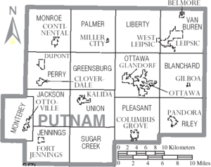
Putnam County has several types of communities, from small villages to larger townships.
Villages
Villages are smaller towns with their own local governments.
- Belmore
- Cloverdale
- Columbus Grove
- Continental
- Dupont
- Fort Jennings
- Gilboa
- Glandorf
- Kalida
- Leipsic
- Miller City
- Ottawa (This is the county seat)
- Ottoville
- Pandora
- West Leipsic
Townships
Townships are areas of land that include villages and rural areas. They also have local governments.
- Blanchard
- Greensburg
- Jackson
- Jennings
- Liberty
- Monroe
- Monterey
- Ottawa
- Palmer
- Perry
- Pleasant
- Riley
- Sugar Creek
- Union
- Van Buren
Census-designated place
This is an area that looks like a town but isn't officially incorporated as a village or city.
Unincorporated communities
These are small groups of homes or businesses that don't have their own local government.
See also
 In Spanish: Condado de Putnam (Ohio) para niños
 | Percy Lavon Julian |
 | Katherine Johnson |
 | George Washington Carver |
 | Annie Easley |


