
Ottoville, Ohio facts for kids
Quick facts for kids
Ottoville, Ohio
|
|
|---|---|
|
Village
|
|

Immaculate Conception Catholic Church
|
|

Location of Ottoville, Ohio
|
|

Location of Ottoville in Putnam County
|
|
| Country | United States |
| State | Ohio |
| County | Putnam |
| Area | |
| • Total | 0.95 sq mi (2.46 km2) |
| • Land | 0.95 sq mi (2.45 km2) |
| • Water | 0.00 sq mi (0.00 km2) |
| Elevation | 742 ft (226 m) |
| Population
(2020)
|
|
| • Total | 966 |
| • Density | 1,020.06/sq mi (393.98/km2) |
| Time zone | UTC-5 (Eastern (EST)) |
| • Summer (DST) | UTC-4 (EDT) |
| ZIP code |
45876
|
| Area code(s) | 419 |
| FIPS code | 39-59052 |
| GNIS feature ID | 2399598 |
| Website | http://www.villageofottoville.org/ |
Ottoville is a small village located in Putnam County, Ohio, United States. It is part of Monterey Township. In 2020, the village had a population of 966 people.
Contents
History of Ottoville
The first plan for a town in Ottoville was made in 1845. This plan was created for a person named John Otto Bredeich. However, this first attempt was not successful.
The town site was planned again in 1873. A post office was opened in 1880 and was first called "Otto." The name was changed to Ottoville in 1881. Ottoville officially became a village in 1890.
Population Growth Over Time
The table below shows how the number of people living in Ottoville has changed over the years.
| Historical population | |||
|---|---|---|---|
| Census | Pop. | %± | |
| 1900 | 369 | — | |
| 1910 | 477 | 29.3% | |
| 1920 | 435 | −8.8% | |
| 1930 | 443 | 1.8% | |
| 1940 | 467 | 5.4% | |
| 1950 | 543 | 16.3% | |
| 1960 | 793 | 46.0% | |
| 1970 | 914 | 15.3% | |
| 1980 | 833 | −8.9% | |
| 1990 | 842 | 1.1% | |
| 2000 | 873 | 3.7% | |
| 2010 | 976 | 11.8% | |
| 2020 | 966 | −1.0% | |
| U.S. Decennial Census | |||
Geography of Ottoville
Ottoville is a small village in terms of its size. The United States Census Bureau states that the village covers a total area of about 2.46 square kilometers (0.95 square miles). Almost all of this area is land, with only a very small part being water.
Ottoville Demographics
Population Details from 2010
According to the census from 2010, there were 976 people living in Ottoville. These people lived in 392 households, and 279 of these were families. The population density was about 1220 people per square mile (471 people per square kilometer).
There were 411 housing units in the village. Most of the people living in Ottoville were White (97.5%). A small number of residents were African American, Asian, or from other races. About 1.7% of the population identified as Hispanic or Latino.
Households and Age
- About 33.7% of households had children under 18 years old.
- Most households (60.7%) were married couples living together.
- About 24.5% of all households were made up of individuals living alone.
- Around 10.2% of households had someone aged 65 or older living by themselves.
The average age of people in the village was 38.7 years.
- 25.3% of residents were under 18 years old.
- 8.3% were between 18 and 24 years old.
- 22.8% were between 25 and 44 years old.
- 27.3% were between 45 and 64 years old.
- 16.2% were 65 years of age or older.
The population was almost evenly split between males and females. About 48.4% were male and 51.6% were female.
Education in Ottoville
The local schools in Ottoville are managed by Ottoville Local Schools. They operate one elementary school and Ottoville High School. Ottoville also has a public library. It is a branch of the Putnam County District Library.
Images for kids
-
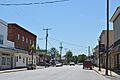
Historic Downtown Ottoville
-
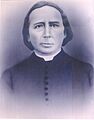
John Otto Bredeich, who founded Ottoville


See also
 In Spanish: Ottoville (Ohio) para niños
