Adams County, Indiana facts for kids
Quick facts for kids
Adams County
|
|
|---|---|

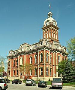
Adams County courthouse in Decatur
|
|

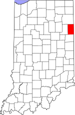
Location within the U.S. state of Indiana
|
|
 Indiana's location within the U.S. |
|
| Country | |
| State | |
| Founded | March 1, 1836 |
| Named for | John Quincy Adams |
| Seat | Decatur |
| Largest city | Decatur |
| Area | |
| • Total | 339.97 sq mi (880.5 km2) |
| • Land | 339.03 sq mi (878.1 km2) |
| • Water | 0.94 sq mi (2.4 km2) 0.28%% |
| Population
(2020)
|
|
| • Total | 35,809 |
| • Estimate
(2023)
|
36,288 |
| • Density | 105.3299/sq mi (40.6681/km2) |
| Time zone | UTC−5 (Eastern) |
| • Summer (DST) | UTC−4 (EDT) |
| Congressional district | 3rd |
| FIPS No. 001 | |
Adams County is located in northeastern Indiana, United States. It shares its eastern border with Ohio. This county was officially created in 1836. The main town, or county seat, is Decatur.
In 2020, the county had a population of 35,809 people. This was a 4.1% increase from 2010. Adams County has four main cities and towns. More than 15,000 people live in these areas. There are also many smaller, unincorporated communities. The county is divided into 12 areas called townships. These townships help provide local services.
Adams County has several important roads. These include four Indiana state roads and three U.S. Routes. There is also one railroad line. In 2017, about a quarter of the county's population was Swiss Amish. These 8,600 people settled in the southern part of the county, especially around Berne.
Contents
History
The idea to create Adams County began on February 7, 1835. The county officially started on March 1, 1836. It was named after John Quincy Adams. He was the sixth President of the United States. The county seat was chosen on May 18 of that same year.
The first non-Native American settlers arrived in Adams County in 1835. They came from New England. These settlers were called "Yankees." They were mostly descendants of English Puritans. These Puritans had settled New England a long time ago. Many of them were part of the Congregational Church. Some had also become Methodists or Baptists. When they arrived, they found thick forests and wild grasslands.
The first Amish families came to Adams County in 1840. Most of them came directly from Switzerland. They kept their Bernese German dialect. They did not adopt the Pennsylvania Dutch dialect that most Amish people speak.
The Yankee settlers built the first courthouse in 1839. It was a two-story wooden building. A jail made of logs was finished in 1837. The current Adams County courthouse was built in Decatur. It was constructed between 1872 and 1873. The cost was about $79,000. J. C. Johnson designed the building. He was a self-taught architect. Christian Boseker from Fort Wayne built it. The courthouse is made of red brick with stone decorations.
Geography
In 2010, Adams County covered about 339.97 square miles. Most of this area, about 339.03 square miles, is land. Only a small part, about 0.94 square miles, is water. This means 99.72% of the county is land.
Adjacent counties
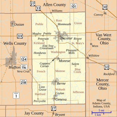
Adams County shares its borders with these other counties:
- Allen County (north)
- Van Wert County, Ohio (northeast)
- Mercer County, Ohio (southeast)
- Jay County (south)
- Wells County (west)
- Whitley County (northwest)
The county has four main towns and cities. They are all located in a line from north to south. Decatur is the largest city and the county seat. It is in the northern part of the county. Here, U.S. Route 27 and U.S. Route 33 meet U.S. Route 224. U.S. Route 27 continues south through Monroe. It then goes through Berne and Geneva.
Communities
Cities
Unincorporated communities
- Ceylon
- Coppess Corner
- Curryville
- Honduras
- Linn Grove
- Magley
- Monmouth
- Perryville
- Peterson
- Pleasant Mills
- Preble
- Rivare
- Salem
- Williams
Townships
- Blue Creek
- French
- Hartford
- Jefferson
- Kirkland
- Monroe
- Preble
- Root
- Saint Marys
- Union
- Wabash
- Washington
Climate and weather
| Weather chart for Decatur, Indiana | |||||||||||||||||||||||||||||||||||||||||||||||
|---|---|---|---|---|---|---|---|---|---|---|---|---|---|---|---|---|---|---|---|---|---|---|---|---|---|---|---|---|---|---|---|---|---|---|---|---|---|---|---|---|---|---|---|---|---|---|---|
| J | F | M | A | M | J | J | A | S | O | N | D | ||||||||||||||||||||||||||||||||||||
|
2.2
32
17
|
2.2
37
21
|
2.9
48
30
|
3.7
61
39
|
3.8
72
50
|
4.4
81
60
|
4
84
64
|
3.7
82
62
|
3
76
54
|
2.6
64
43
|
3.2
50
34
|
2.8
37
23
|
||||||||||||||||||||||||||||||||||||
| temperatures in °F precipitation totals in inches source: The Weather Channel |
|||||||||||||||||||||||||||||||||||||||||||||||
|
Metric conversion
|
|||||||||||||||||||||||||||||||||||||||||||||||
Adams County has a humid continental climate. This means it has cold winters and hot summers. The average temperatures in Decatur change throughout the year. In January, the average low is 17°F. In July, the average high is 84°F. The lowest temperature ever recorded was -24°F in January 1985. The highest was 107°F in July 1934. The county gets about 2 to 4 inches of rain each month. June usually has the most rain.
Demographics
| Historical population | |||
|---|---|---|---|
| Census | Pop. | %± | |
| 1840 | 2,264 | — | |
| 1850 | 5,797 | 156.1% | |
| 1860 | 9,252 | 59.6% | |
| 1870 | 11,382 | 23.0% | |
| 1880 | 15,385 | 35.2% | |
| 1890 | 20,181 | 31.2% | |
| 1900 | 22,232 | 10.2% | |
| 1910 | 21,840 | −1.8% | |
| 1920 | 20,503 | −6.1% | |
| 1930 | 19,957 | −2.7% | |
| 1940 | 21,254 | 6.5% | |
| 1950 | 22,393 | 5.4% | |
| 1960 | 24,643 | 10.0% | |
| 1970 | 26,871 | 9.0% | |
| 1980 | 29,619 | 10.2% | |
| 1990 | 31,095 | 5.0% | |
| 2000 | 33,625 | 8.1% | |
| 2010 | 34,387 | 2.3% | |
| 2020 | 35,809 | 4.1% | |
| 2023 (est.) | 36,288 | 5.5% | |
| U.S. Decennial Census 1790-1960 1900-1990 1990-2000 2010-2015 2019 2020 |
|||
In 2020, there were 35,809 people living in Adams County. There were also 12,481 households. About 31.3% of households had children under 18. Most households (55.1%) were married couples. The average household had 2.79 people. The average family had 3.39 people. The average age of people in the county was 33.5 years.
Most people (77.1%) own their homes. About 8.7% rent their homes. About 40.6% of the population has a high school degree or higher. About 15.5% have a bachelor's degree or higher. Many people work in manufacturing (31.2%). Others work in education, health care, and social services (17.6%). Retail jobs make up 10.3% of employment.
The average income for a household was $52,504. For a family, it was $65,609. About 16.8% of the population lived below the poverty line. This included 24.5% of those under 18.
2020 census
| Race | Num. | Perc. |
|---|---|---|
| White (NH) | 33,080 | 92.4% |
| Black or African American (NH) | 171 | 0.5% |
| Native American (NH) | 80 | 0.22% |
| Asian (NH) | 135 | 0.4% |
| Pacific Islander (NH) | 4 | 0.01% |
| Other/Mixed (NH) | 702 | 2% |
| Hispanic or Latino | 1,637 | 4.6% |
Amish community
The Amish community in Adams County is called the Swiss Amish. Their ancestors came to the county in 1840. They speak a special Bernese dialect every day. In 2017, there were 8,595 Swiss Amish people. They belonged to 58 different church groups. This made up 24.2% of the county's total population.
Religion
Religion in Adams County, according to ARDA (2020) Evangelical Churches (37.4%) Anabaptist Church ( Amish ) (22.7%) Catholic Church (8.4%) Mainline Protestant Churches (7.1%) Black Protestant Churches (5.9%) Others (0.9%) None* (17.5%)
*"Nones" refers to people who don't identify with a specific religion. This group includes people who might have some spiritual beliefs but don't attend church regularly. For example, many "Nones" still believe in God or a higher power.
Transportation
Three major U.S. Routes cross Adams County. U.S. Route 27 and U.S. Route 33 enter from Fort Wayne in Allen County. They pass through Decatur. Then, U.S. Route 27 goes south through Monroe, Berne, and Geneva. U.S. Route 33 heads southeast into Ohio. U.S. Route 224 crosses the northern part of the county from west to east. It meets U.S. Routes 27 and 33 in Decatur. Then it continues into Ohio.
Several Indiana State Roads also run through the county. Indiana State Road 124 goes east-west. It runs from Bluffton to the Ohio border. Indiana State Road 101 goes north-south. It connects State Road 124 to Allen County. Indiana State Road 116 crosses west-east. It goes from Bluffton to Geneva. Indiana State Road 218 runs west-east through the southern part of the county, passing through Berne.
CSX Transportation operates a train line. It runs from Decatur northwest toward Fort Wayne.
Education
Public schools in Adams County are managed by three groups. These are North Adams Community Schools, Adams Central Community Schools, and South Adams Schools. The Diocese of Fort Wayne and Lutheran Schools of Indiana also run schools here. In total, there are 13 schools in the county.
Festivals and Fairs in Adams County
- Adams County 4-H Fair (Monroe)
- Swiss Days (Berne)
- Calithumpian Festival (Decatur)
- Festival of Kekionga (Decatur)
- 4th of July Fireworks, (Down Town Decatur)
- Summer Concert Series (Downtown Decatur)
- DeKeggar BBQ and Beer Brewing Competition (Downtown Decatur)
- Highland Games - Old Scottish Style Strength Competition (Downtown Decatur)
Media
Radio
- WZBD (Berne)
Newspapers
- The Decatur Daily Democrat (Decatur)
- Berne Tri-Weekly (Berne)
Notable people
- Gene Stratton-Porter (1863 – 1924) was an author and nature photographer. She lived in Decatur and Geneva from 1886 to 1913.
- Chemist Richard R. Schrock was born in Berne in 1945. He won the Nobel Prize in organic chemistry in 2005.
- Director David Anspaugh (born 1946) was born in Decatur. He directed famous movies like Hoosiers and Rudy.
- Sculptor David Smith (1906 – 1965) was born in Decatur.
See also
 In Spanish: Condado de Adams (Indiana) para niños
 | William M. Jackson |
 | Juan E. Gilbert |
 | Neil deGrasse Tyson |


