Whitley County, Indiana facts for kids
Quick facts for kids
Whitley County
|
|
|---|---|

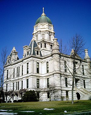
Whitley County courthouse in Columbia City
|
|

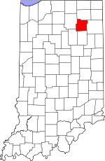
Location within the U.S. state of Indiana
|
|
 Indiana's location within the U.S. |
|
| Country | |
| State | |
| Founded | February 7, 1835 (authorized) 1838 (organized) |
| Named for | William Whitley |
| Seat | Columbia City |
| Largest city | Columbia City |
| Area | |
| • Total | 337.91 sq mi (875.2 km2) |
| • Land | 335.57 sq mi (869.1 km2) |
| • Water | 2.34 sq mi (6.1 km2) 0.69%% |
| Population
(2020)
|
|
| • Total | 34,191 |
| • Density | 101.6/sq mi (39.2/km2) |
| Time zone | UTC−5 (Eastern) |
| • Summer (DST) | UTC−4 (EDT) |
| Congressional district | 3rd |
| Indiana county number 92 Last alphabetical county in Indiana. |
|
Whitley County is a rural area in the U.S. state of Indiana. It's a place where many people live in the countryside. In 2020, about 34,191 people lived here. Whitley County is the 49th largest county in Indiana.
The main town and county seat is Columbia City. It's the only official city in the county. Whitley County has the highest number (92) on Indiana license plates. This is because it's the last county in Indiana when you list them in alphabetical order. Whitley County is also part of the larger Fort Wayne Metropolitan Statistical Area.
Contents
History of Whitley County
Indiana became a state in 1816. On February 7, 1835, the state government decided to create thirteen new counties. Whitley County was one of them.
The county was named after Colonel William Whitley. He was a brave soldier who died in the War of 1812. This battle was called the Battle of the Thames.
The first settlers who were not Native Americans arrived in Whitley County in 1835. They came after the Black Hawk War ended and the Erie Canal was finished. Many of these early settlers came from New England. They were often descendants of the English Puritans who had settled New England a long time ago.
These settlers were mostly part of the Congregational Church. But because of a religious movement called the Second Great Awakening, some had changed to Methodism or become Baptists. The government of Whitley County officially started in 1838. Later, in the late 1870s, people also started moving to Whitley County from Germany and Ireland.
Geography of Whitley County
Before settlers arrived, Whitley County had many thick forests. There were also many lakes, especially in the northern part. Today, most of the land is used for farming or for towns and cities.
The highest point in the county is about 1,000 feet (305 m) above sea level. This small hill is northeast of Cedar Lake. Two rivers flow through the county. The Eel River goes southwest through the lower part. The Blue River also flows southwest through the upper part.
According to the 2010 United States Census, Whitley County covers about 337.91 square miles (875.2 km2). Most of this area, about 335.57 square miles (869.1 km2), is land. Only a small part, about 2.34 square miles (6.1 km2), is water.
Neighboring Counties
- Noble County - north
- Allen County - east
- Huntington County - south
- Wabash County - southwest
- Kosciusco County - west
Cities and Towns in Whitley County
- Columbia City (main city and county seat)
- Churubusco
- Larwill
- South Whitley
Special Places (Census-designated place)
Small Communities (Unincorporated places)
Townships in Whitley County
- Cleveland
- Columbia
- Etna-Troy
- Jefferson
- Richland
- Smith
- Thorncreek
- Union
- Washington
Lakes in Whitley County
- Blue Lake
- Brown Lake
- Cedar Lake
- Crooked Lake (part)
- Dollar Lake
- Goose Lake
- Indian Lake
- Little Cedar Lake
- Loon Lake (part)
- Mud Lake
- New Lake
- Old Lake
- Rine Lake
- Robinson Lake (part)
- Round Lake
- Scott Lake
- Shriner Lake
- Tadpole Lake
- Troy Cedar Lake
- Winters Lake
Protected Natural Areas
- Deniston Resource Area
- Goose Lake Wetland Conservation Area
- Pisgah Marsh Nongame Area (part)
Main Roads in Whitley County
 U.S. Route 24
 U.S. Route 30
 U.S. Route 33
 Indiana State Road 5
 Indiana State Road 9
 Indiana State Road 14
 Indiana State Road 105
 Indiana State Road 109
 Indiana State Road 114
 Indiana State Road 205
Climate and Weather in Whitley County
| Weather chart for Columbia City, Indiana | |||||||||||||||||||||||||||||||||||||||||||||||
|---|---|---|---|---|---|---|---|---|---|---|---|---|---|---|---|---|---|---|---|---|---|---|---|---|---|---|---|---|---|---|---|---|---|---|---|---|---|---|---|---|---|---|---|---|---|---|---|
| J | F | M | A | M | J | J | A | S | O | N | D | ||||||||||||||||||||||||||||||||||||
|
2.1
31
14
|
1.8
35
18
|
2.9
46
27
|
3.7
58
37
|
3.7
70
48
|
4.4
79
58
|
3.8
83
62
|
3.6
81
59
|
3.5
74
51
|
2.8
62
40
|
3.3
48
31
|
2.9
36
21
|
||||||||||||||||||||||||||||||||||||
| temperatures in °F precipitation totals in inches source: The Weather Channel |
|||||||||||||||||||||||||||||||||||||||||||||||
|
Metric conversion
|
|||||||||||||||||||||||||||||||||||||||||||||||
The weather in Columbia City changes throughout the year. In January, the average low temperature is about 14°F (–10°C). In July, the average high temperature is about 83°F (28°C).
The coldest temperature ever recorded was –24°F (–31°C) in January 1994. The hottest was 103°F (39°C) in June 1988. The amount of rain and snow also changes. February usually has the least, about 1.80 inches (4.6 cm). June usually has the most, about 4.44 inches (11.3 cm).
People of Whitley County (Demographics)
| Historical population | |||
|---|---|---|---|
| Census | Pop. | %± | |
| 1840 | 1,237 | — | |
| 1850 | 5,190 | 319.6% | |
| 1860 | 10,730 | 106.7% | |
| 1870 | 14,399 | 34.2% | |
| 1880 | 16,941 | 17.7% | |
| 1890 | 17,768 | 4.9% | |
| 1900 | 17,328 | −2.5% | |
| 1910 | 16,892 | −2.5% | |
| 1920 | 15,660 | −7.3% | |
| 1930 | 15,931 | 1.7% | |
| 1940 | 17,001 | 6.7% | |
| 1950 | 18,828 | 10.7% | |
| 1960 | 20,954 | 11.3% | |
| 1970 | 23,395 | 11.6% | |
| 1980 | 26,215 | 12.1% | |
| 1990 | 27,651 | 5.5% | |
| 2000 | 30,707 | 11.1% | |
| 2010 | 33,292 | 8.4% | |
| 2020 | 34,191 | 2.7% | |
| 2023 (est.) | 34,742 | 4.4% | |
| US Decennial Census 1790-1960 1900-1990 1990-2000 2010-2013 2017 |
|||
In 2010, there were 33,292 people living in Whitley County. There were 13,001 households (groups of people living together) and 9,228 families. The population density was about 99 people per square mile.
Most people in the county were white (97.6%). A small number were Asian, American Indian, or Black. About 1.5% of the people were of Hispanic or Latino background. Many people had ancestors from Germany (38.2%), Ireland (12.6%), or England (9.3%).
About 32.5% of households had children under 18 living with them. The average household had 2.53 people. The average age of people in the county was 40.1 years old.
The average income for a household was $47,697 per year. For a family, it was $63,487. About 6.8% of all people in the county lived below the poverty line. This included 7.2% of those under 18.
See also
 In Spanish: Condado de Whitley (Indiana) para niños
 | William Lucy |
 | Charles Hayes |
 | Cleveland Robinson |

