Raber, Indiana facts for kids
Quick facts for kids
Raber, Indiana
|
|
|---|---|

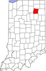
Whitley County's location in Indiana
|
|
| Country | United States |
| State | Indiana |
| County | Whitley |
| Township | Jefferson |
| Elevation | 846 ft (258 m) |
| Time zone | UTC-5 (Eastern (EST)) |
| • Summer (DST) | UTC-4 (EDT) |
| ZIP code |
46725
|
| Area code(s) | 260 |
| FIPS code | 18-62604 |
| GNIS feature ID | 441712 |
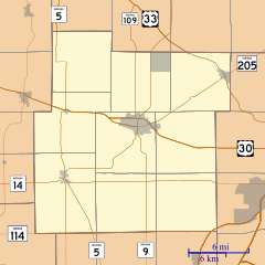
Raber is a small, unincorporated community located in Jefferson Township, Whitley County, in the U.S. state of Indiana. An "unincorporated community" means it's a group of homes and businesses that isn't officially a town or city with its own local government. It's part of the larger Whitley County.
A Look Back: Raber's History
Raber got its name from Samuel Raber. He was one of the first people to settle and live in this area. A post office, which is where people send and receive mail, opened in Raber in 1884. It served the community for many years before closing in 1902.
Where is Raber? Geography
Raber is located at specific coordinates on a map: 41°05′09″N 85°25′58″W / 41.08583°N 85.43278°W. This means it is at 41 degrees, 5 minutes, 9 seconds North latitude and 85 degrees, 25 minutes, 58 seconds West longitude. These numbers help pinpoint its exact spot in the world.
 | Janet Taylor Pickett |
 | Synthia Saint James |
 | Howardena Pindell |
 | Faith Ringgold |


