
Wabash County, Indiana facts for kids
Quick facts for kids
Wabash County
|
|
|---|---|

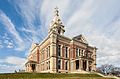
Wabash County Courthouse
|
|

Location within the U.S. state of Indiana
|
|
 Indiana's location within the U.S. |
|
| Country | |
| State | |
| Founded | January 1820; organized 1835 |
| Named for | Wabash River |
| Seat | Wabash |
| Largest city | Wabash |
| Area | |
| • Total | 420.98 sq mi (1,090.3 km2) |
| • Land | 412.43 sq mi (1,068.2 km2) |
| • Water | 8.54 sq mi (22.1 km2) 2.03%% |
| Population
(2020)
|
|
| • Total | 30,976 |
| • Estimate
(2023)
|
30,670 |
| • Density | 73.5807/sq mi (28.4097/km2) |
| Time zone | UTC−5 (Eastern) |
| • Summer (DST) | UTC−4 (EDT) |
| Congressional district | 2nd |
| Indiana county number 85 | |
Wabash County is a county in the north-central part of Indiana, a state in the United States. In 2020, about 30,976 people lived here. The main city and county seat (where the county government is) is Wabash.
Contents
History
Long ago, thousands of years before Europeans arrived, different groups of Native American people lived in the Wabash County area. In the 1600s, French explorers and traders met the Miami Native Americans here.
Wabash County was first created in January 1820. It was part of a large area bought from Native American tribes in 1818. Many counties were later formed from this land. The Wabash County we know today was officially set up in 1835.
The name "Wabash" comes from the French name for the Wabash River, Ouabache. The French got this name from the Native American word Wabashike. This word means "pure white." Much of the river bottom used to be white limestone, which is now covered by mud.
Geography
Wabash County covers about 420.98 square miles. Most of this area, about 412.43 square miles, is land. The rest, about 8.54 square miles, is water.

Neighboring Counties
- Kosciusko County (north)
- Whitley County (northeast)
- Huntington County (east)
- Grant County (south)
- Miami County (west)
- Fulton County (northwest)
Cities and Towns
- Wabash (the only city)
Towns
Other Communities
These are smaller places that are not officially cities or towns.
- Laketon
- Somerset
- America
- Bolivar
- College Corner
- Disko
- Ijamsville
- Liberty Mills
- Lincolnville
- Mount Vernon
- Newton
- Pioneer
- Richvalley
- Servia
- South Haven
- Speicherville
- Stockdale
- Sunnymede
- Treaty
- Urbana
- Valley Brook
Former Communities
These places no longer exist or are no longer recognized.
- Dora
- Rose Hill
Townships
Counties in Indiana are divided into smaller areas called townships.
- Chester
- Lagro
- Liberty
- Noble
- Paw Paw
- Pleasant
- Waltz
Main Roads
 U.S. Route 24
 Indiana State Road 13
 Indiana State Road 15
 Indiana State Road 16
 Indiana State Road 114
 Indiana State Road 115
 Indiana State Road 124
 Indiana State Road 218
 Indiana State Road 524
Climate and Weather
| Weather chart for Wabash, Indiana | |||||||||||||||||||||||||||||||||||||||||||||||
|---|---|---|---|---|---|---|---|---|---|---|---|---|---|---|---|---|---|---|---|---|---|---|---|---|---|---|---|---|---|---|---|---|---|---|---|---|---|---|---|---|---|---|---|---|---|---|---|
| J | F | M | A | M | J | J | A | S | O | N | D | ||||||||||||||||||||||||||||||||||||
|
2.2
31
14
|
1.9
36
17
|
2.7
47
27
|
3.5
60
37
|
4.1
71
48
|
4.2
80
58
|
4.1
83
61
|
4
81
59
|
3.2
75
51
|
2.8
63
40
|
3.1
49
31
|
2.7
36
20
|
||||||||||||||||||||||||||||||||||||
| temperatures in °F precipitation totals in inches source: The Weather Channel |
|||||||||||||||||||||||||||||||||||||||||||||||
|
Metric conversion
|
|||||||||||||||||||||||||||||||||||||||||||||||
In Wabash, the average temperature in January is about 14°F (coldest month). In July, the average temperature is about 83°F (warmest month). The coldest temperature ever recorded was -24°F in January 1985. The hottest was 103°F in June 1988.
The amount of rain and snow changes throughout the year. February usually has the least precipitation, about 1.89 inches. June typically has the most, about 4.23 inches.
People and Population
| Historical population | |||
|---|---|---|---|
| Census | Pop. | %± | |
| 1840 | 2,756 | — | |
| 1850 | 12,138 | 340.4% | |
| 1860 | 17,547 | 44.6% | |
| 1870 | 21,305 | 21.4% | |
| 1880 | 25,241 | 18.5% | |
| 1890 | 27,126 | 7.5% | |
| 1900 | 28,235 | 4.1% | |
| 1910 | 26,926 | −4.6% | |
| 1920 | 27,231 | 1.1% | |
| 1930 | 25,170 | −7.6% | |
| 1940 | 26,601 | 5.7% | |
| 1950 | 29,047 | 9.2% | |
| 1960 | 32,605 | 12.2% | |
| 1970 | 35,553 | 9.0% | |
| 1980 | 36,640 | 3.1% | |
| 1990 | 35,069 | −4.3% | |
| 2000 | 34,960 | −0.3% | |
| 2010 | 32,888 | −5.9% | |
| 2020 | 30,976 | −5.8% | |
| 2023 (est.) | 30,670 | −6.7% | |
| U.S. Decennial Census 1790-1960 1900-1990 1990-2000 2010-2013 |
|||
In 2010, there were 32,888 people living in Wabash County. There were 12,777 households and 8,733 families. The population density was about 79.7 people per square mile.
Most people in the county were white (96.6%). Other groups included American Indian (0.7%), black or African American (0.5%), and Asian (0.4%). About 2.1% of the population was of Hispanic or Latino origin.
Many people had German (31.3%), American (18.1%), English (10.1%), or Irish (10.0%) backgrounds.
About 29.9% of households had children under 18 living with them. The average household had 2.43 people. The average family had 2.92 people. The average age of people in the county was 41.2 years old.
The average yearly income for a household was $47,697. For a family, it was $52,758. About 11.6% of all people in the county lived below the poverty line. This means their income was below a certain level.
Images for kids
-
Wabash County Courthouse
See also
 In Spanish: Condado de Wabash (Indiana) para niños
