Kosciusko County, Indiana facts for kids
Quick facts for kids
Kosciusko County
|
|
|---|---|

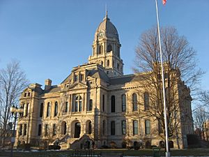
Kosciusko County Courthouse in Warsaw
|
|

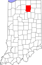
Location within the U.S. state of Indiana
|
|
 Indiana's location within the U.S. |
|
| Country | |
| State | |
| Founded | February 7, 1835 (authorized) 1836 (organized) |
| Named for | Tadeusz Kościuszko |
| Seat | Warsaw |
| Largest city | Warsaw |
| Area | |
| • Total | 554.39 sq mi (1,435.9 km2) |
| • Land | 531.38 sq mi (1,376.3 km2) |
| • Water | 23.01 sq mi (59.6 km2) 4.15%% |
| Population
(2020)
|
|
| • Total | 80,240 |
| • Estimate
(2023)
|
80,364 |
| • Density | 144.736/sq mi (55.883/km2) |
| Time zone | UTC−5 (Eastern) |
| • Summer (DST) | UTC−4 (EDT) |
| Congressional districts | 2nd, 3rd |
| Indiana county number 43 | |
Kosciusko County (pronounced KOS-kee-US-koh) is a county in the state of Indiana. In 2020, about 80,240 people lived here. The main city and county seat is Warsaw.
This county was officially started in 1836. It was named after Tadeusz Kościuszko, a famous Polish general. He helped America during the American Revolutionary War. The county seat, Warsaw, is also named after Warsaw, the capital city of Poland.
Contents
History of Kosciusko County
The Indiana State Legislature decided to create Kosciusko County on February 7, 1835. This law also created twelve other counties in northeast Indiana. The county government officially began in 1836. Since then, the borders of Kosciusko County have stayed exactly the same.
Exploring Kosciusko County's Geography
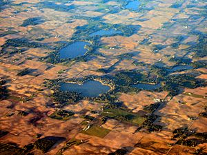
Kosciusko County has gentle, rolling hills. Many lakes and rivers are scattered across the land. Most of the area is used for farming or city development. The highest point in the county is a hill northeast of Dewart Lake. It is about 1,025 feet (312 meters) above sea level.
The Tippecanoe River flows west through the middle of the county. The Eel River flows southwest through the county's southeast corner.
In 2010, the county covered a total area of 554.39 square miles. About 531.38 square miles (95.85%) of this is land. The remaining 23.01 square miles (4.15%) is water.
Neighboring Counties
- Elkhart County - north
- Noble County - northeast
- Whitley County - southeast
- Wabash County - south
- Fulton County - southwest
- Marshall County - west
Main Roads and Highways
Lakes in the County
- Banning Lake
- Beaver Dam Lake
- Big Barbee Lake
- Big Chapman Lake
- Carr Lake
- Center Lake
- Dewart Lake
- Diamond Lake
- Fish Lake
- Goose Lake
- Hoffman Lake
- Hill Lake
- Irish Lake
- James Lake
- Kuhn Lake
- Lake Wawasee
- Little Barbee Lake
- Little Chapman Lake
- Loon Lake
- McClures Lake
- Muskellunge Lake
- Palestine Lake
- Papakeechie Lake
- Pike Lake
- Ridinger Lake
- Rock Lake (part)
- Sechrist Lake
- Shoe Lake
- Silver Lake
- Stanton Lake
- Syracuse Lake
- Tippecanoe Lake
- Waubee Lake
- Winona Lake
- Yellow Creek Lake
Protected Natural Areas
- Center Lake Wetland Conservation Area
- Edmund and Virginia Ball Nature Preserve
- Pisgah Marsh Nongame Area (part)
Cities and Towns
Small Communities (Unincorporated)
- Atwood
- Barbee
- Bayfield
- Beaver Dam
- Bell Rohr Park
- Buttermilk Point
- Cedar Point
- Clunette
- DeFries Landing
- Enchanted Hills
- Forest Glen
- Gravelton
- Hastings
- Highbanks
- Highlands Park
- Island Park
- Kalorama Park
- Kanata Manayunk
- Kinsey
- Lakeside Park
- Lakeview Spring
- Lowman Corner
- Marineland Gardens
- Milford Junction
- Mineral Springs
- Monoquet
- Musquabuck Park
- Oakwood Park
- Osborn Landing
- Oswego
- Packerton
- Palestine
- Pickwick Park
- Potawatomi Park
- Redmon Park
- Sevastopol
- Shady Banks
- South Park
- Stoneburner Landing
- Stony Ridge
- Vawter Park
- Walker Park
- Wawasee
- Wawasee Village
- Wooster
- Yellowbanks
Townships in Kosciusko County
- Clay
- Etna
- Franklin
- Harrison
- Jackson
- Jefferson
- Lake
- Monroe
- Plain
- Prairie
- Scott
- Seward
- Tippecanoe
- Turkey Creek
- Van Buren
- Washington
- Wayne
Climate and Weather in Warsaw
| Weather chart for Warsaw, Indiana | |||||||||||||||||||||||||||||||||||||||||||||||
|---|---|---|---|---|---|---|---|---|---|---|---|---|---|---|---|---|---|---|---|---|---|---|---|---|---|---|---|---|---|---|---|---|---|---|---|---|---|---|---|---|---|---|---|---|---|---|---|
| J | F | M | A | M | J | J | A | S | O | N | D | ||||||||||||||||||||||||||||||||||||
|
1.9
31
15
|
1.5
35
18
|
2.1
47
28
|
3.4
59
38
|
3.8
71
49
|
4.5
79
58
|
3.7
82
62
|
4.1
80
60
|
3.2
73
53
|
3
62
42
|
3
48
32
|
2.6
35
21
|
||||||||||||||||||||||||||||||||||||
| temperatures in °F precipitation totals in inches source: The Weather Channel |
|||||||||||||||||||||||||||||||||||||||||||||||
|
Metric conversion
|
|||||||||||||||||||||||||||||||||||||||||||||||
In Warsaw, the average temperature in January is about 15°F (-9°C). In July, it's around 82°F (28°C). The coldest temperature ever recorded was -25°F (-32°C) in January 1985. The hottest was 103°F (39°C) in July 1976.
The amount of rain and snow changes throughout the year. February usually has the least precipitation, about 1.45 inches. June typically has the most, with about 4.51 inches.
Community Life
Local Newspapers
- Times-Union
- The Mail-Journal
- The PAPER
- Ink Free News
Radio Stations
- WRSW-AM 1480/99.7 FM (News Now Warsaw)
- WRSW-FM (Classic Hits 107.3 WRSW
- WAWC-FM (Willie 103.5)
Education in Kosciusko County
School Districts
- Tippecanoe Valley School Corporation
- Triton School Corporation
- Warsaw Community Schools
- Wawasee Community School Corporation
- Whitko Community School Corporation
- Wa-Nee Community Schools
Population Changes Over Time
| Historical population | |||
|---|---|---|---|
| Census | Pop. | %± | |
| 1840 | 4,170 | — | |
| 1850 | 10,243 | 145.6% | |
| 1860 | 17,418 | 70.0% | |
| 1870 | 23,531 | 35.1% | |
| 1880 | 26,494 | 12.6% | |
| 1890 | 28,645 | 8.1% | |
| 1900 | 29,109 | 1.6% | |
| 1910 | 27,936 | −4.0% | |
| 1920 | 27,120 | −2.9% | |
| 1930 | 27,488 | 1.4% | |
| 1940 | 29,561 | 7.5% | |
| 1950 | 33,002 | 11.6% | |
| 1960 | 40,373 | 22.3% | |
| 1970 | 48,127 | 19.2% | |
| 1980 | 59,555 | 23.7% | |
| 1990 | 65,294 | 9.6% | |
| 2000 | 74,057 | 13.4% | |
| 2010 | 77,358 | 4.5% | |
| 2020 | 80,240 | 3.7% | |
| 2023 (est.) | 80,364 | 3.9% | |
| US Decennial Census 1790-1960 1900-1990 1990-2000 2010-2013 2020 |
|||
In 2010, Kosciusko County had 77,358 people living there. There were 29,197 households, which are groups of people living together. The population density was about 145.6 people per square mile. Most people in the county were white (93.3%). About 7.3% of the population was of Hispanic or Latino background.
The average household had 2.60 people. The average family had 3.07 people. The median age of people in the county was 37.7 years old.
Famous People from Kosciusko County
- Ambrose Bierce, a writer and newspaper columnist who fought in the Civil War.
- Chris Schenkel, a well-known sportscaster for ABC Sports. He lived in Leesburg, Indiana.
- Rick Fox, a retired professional basketball player from the NBA. He lived in Warsaw, Indiana.
See also
 In Spanish: Condado de Kosciusko para niños
 | Selma Burke |
 | Pauline Powell Burns |
 | Frederick J. Brown |
 | Robert Blackburn |


