Fulton County, Indiana facts for kids
Quick facts for kids
Fulton County
|
|
|---|---|

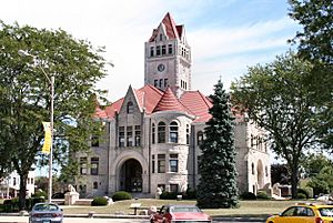
Fulton County courthouse in Rochester
|
|

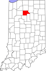
Location within the U.S. state of Indiana
|
|
 Indiana's location within the U.S. |
|
| Country | |
| State | |
| Founded | 1836 |
| Named for | Robert Fulton |
| Seat | Rochester |
| Largest city | Rochester |
| Area | |
| • Total | 371.26 sq mi (961.6 km2) |
| • Land | 368.39 sq mi (954.1 km2) |
| • Water | 2.88 sq mi (7.5 km2) 0.78%% |
| Population
(2020)
|
|
| • Total | 20,480 |
| • Estimate
(2023)
|
20,358 |
| • Density | 55.163/sq mi (21.299/km2) |
| Time zone | UTC−5 (Eastern) |
| • Summer (DST) | UTC−4 (EDT) |
| Congressional district | 2nd |
| Indiana county number 25 | |
Fulton County is a county in the state of Indiana, United States. In 2020, about 20,480 people lived there. The main town and county seat is Rochester.
Contents
History of Fulton County
The first non-Native Americans to visit what is now Fulton County were French traders. They did not stay permanently. By the 1830s, there were no French people living in the area.
Early Settlers
In the 1820s and 1830s, many people from New England started moving to Indiana. These settlers were often called "Yankees." They were descendants of English Puritans who had settled New England long ago. Many came directly from New England. Others came from upstate New York, where their parents had moved after the American Revolution.
Northern Indiana, including Fulton County, shared a lot of its early culture with New England. This was because so many settlers came from there.
Why People Moved
One reason for this big move was that New England was becoming crowded. Families were large, often with ten children. Everyone wanted their own land to farm. But there wasn't enough land for everyone in New England. So, many settlers began moving to the Midwestern United States.
The Erie Canal helped them travel more easily. This canal made it simpler to get to the Midwest, leading to even more people moving. The end of the Black Hawk War also made the region safer for settlers.
First Permanent Homes
People from the United States did not try to settle Fulton County permanently until after the Black Hawk War. The first permanent settlers arrived in September and October 1832. Most came from New England. Some were from upstate New York. Many came from places like Franklin County, Massachusetts, Grafton County, New Hampshire, and Orange County, Vermont. There were also farming families from Maine and northern Connecticut. At first, almost all of these settlers were farmers.
These settlers were mostly part of the Congregational Church. However, some had joined the Methodist or Baptist churches. This happened because of a religious movement called the Second Great Awakening.
Founding Rochester
When the New Englanders arrived, the area was mostly thick forests and wild prairies. They started farms, built roads, and set up government buildings. By spring 1833, the settlement was a successful farming community.
The town of Rochester was planned in 1835. Its founder, Alexander Chamberlain, named it after his old hometown of Rochester, New York. The Rochester post office opened in 1836.
Naming the County
Fulton County was officially formed in 1836. It was named after Robert Fulton. He was famous for inventing the steamboat.
Native Americans in the area believed a scary monster lived in Lake Manitou. Because of this, they never lived near the lake. Early settlers also called it the Devil's Lake. Many people reported seeing a monster there.
A sad event called the Potawatomi Trail of Death passed through the county in 1838.
Geography of Fulton County
Fulton County covers about 371.26 square miles. Most of this (about 368.39 square miles) is land. The rest (about 2.88 square miles) is water.
Cities and Towns
- Akron
- Athens (not officially a city or town)
- Delong (not officially a city or town)
- Fulton
- Grass Creek (not officially a city or town)
- Kewanna
- Leiters Ford (not officially a city or town)
- Rochester
- Tiosa (not officially a city or town)
Townships
- Aubbeenaubbee
- Henry
- Liberty
- Newcastle
- Richland
- Rochester
- Union
- Wayne
Major Roads
Railroads
- Fulton County Railroad
Neighboring Counties
- Marshall County (north)
- Kosciusko County (northeast)
- Wabash County (east)
- Miami County (southeast)
- Cass County (south)
- Pulaski County (west)
- Starke County (northwest)
Climate and Weather
| Weather chart for Rochester, Indiana | |||||||||||||||||||||||||||||||||||||||||||||||
|---|---|---|---|---|---|---|---|---|---|---|---|---|---|---|---|---|---|---|---|---|---|---|---|---|---|---|---|---|---|---|---|---|---|---|---|---|---|---|---|---|---|---|---|---|---|---|---|
| J | F | M | A | M | J | J | A | S | O | N | D | ||||||||||||||||||||||||||||||||||||
|
2
30
15
|
1.7
35
18
|
2.7
47
28
|
3.8
59
38
|
4.2
71
49
|
4.1
80
59
|
3.8
84
63
|
3.7
82
60
|
3.4
75
52
|
2.9
63
41
|
3.4
48
32
|
2.7
36
21
|
||||||||||||||||||||||||||||||||||||
| temperatures in °F precipitation totals in inches source: The Weather Channel |
|||||||||||||||||||||||||||||||||||||||||||||||
|
Metric conversion
|
|||||||||||||||||||||||||||||||||||||||||||||||
In Rochester, the average temperatures change throughout the year. January is usually the coldest month, with lows around 15°F. July is the warmest, with highs around 84°F.
The coldest temperature ever recorded was -25°F in January 1985. The hottest was 103°F in July 1980. The amount of rain and snow also changes. February usually gets the least, about 1.74 inches. May gets the most, about 4.16 inches.
Population and People
| Historical population | |||
|---|---|---|---|
| Census | Pop. | %± | |
| 1840 | 1,993 | — | |
| 1850 | 5,982 | 200.2% | |
| 1860 | 9,422 | 57.5% | |
| 1870 | 12,726 | 35.1% | |
| 1880 | 14,301 | 12.4% | |
| 1890 | 16,746 | 17.1% | |
| 1900 | 17,453 | 4.2% | |
| 1910 | 16,879 | −3.3% | |
| 1920 | 16,478 | −2.4% | |
| 1930 | 15,038 | −8.7% | |
| 1940 | 15,577 | 3.6% | |
| 1950 | 16,565 | 6.3% | |
| 1960 | 16,957 | 2.4% | |
| 1970 | 16,984 | 0.2% | |
| 1980 | 19,335 | 13.8% | |
| 1990 | 18,840 | −2.6% | |
| 2000 | 20,511 | 8.9% | |
| 2010 | 20,836 | 1.6% | |
| 2020 | 20,480 | −1.7% | |
| 2023 (est.) | 20,358 | −2.3% | |
| U.S. Decennial Census 1790-1960 1900-1990 1990-2000 2010 |
|||
In 2010, there were 20,836 people living in Fulton County. There were 8,237 households and 5,736 families. On average, about 56.6 people lived in each square mile.
Most people in the county were white (95.0%). Other groups included black or African American (0.7%), Asian (0.5%), and American Indian (0.5%). About 4.2% of the population was of Hispanic or Latino background.
Households and Income
About 32.2% of households had children under 18 living with them. Most households (54.2%) were married couples. The average household had 2.50 people, and the average family had 2.97 people. The average age of people in the county was 40.3 years.
The median income for a household was about $47,697. This means half of the households earned more than this, and half earned less. About 11.3% of all people in the county lived below the poverty line. This included 15.1% of those under 18.
2020 Census Update
As of the 2020 United States Census, the population of Fulton County was 20,480.
| Race | Num. | Perc. |
|---|---|---|
| White (Non-Hispanic) | 18,776 | 91.7% |
| Black or African American (Non-Hispanic) | 141 | 0.68% |
| Native American (Non-Hispanic) | 64 | 0.3% |
| Asian (Non-Hispanic) | 76 | 0.37% |
| Pacific Islander (Non-Hispanic) | 0 | 0% |
| Other/Mixed (Non-Hispanic) | 679 | 3.3% |
| Hispanic or Latino | 1,068 | 5.2% |
Education
Schools in Fulton County are managed by several school corporations. These include the Caston School Corporation, the Rochester Community School Corporation, Culver Community School Corporation, and the Tippecanoe Valley School Corporation.
High Schools and Middle Schools
- Caston Junior-Senior High School
- Rochester Community High School
- Rochester Middle School
- Tippecanoe Valley High School
- Tippecanoe Valley Middle School
Elementary Schools
- Akron Elementary
- Caston Elementary School
- Columbia Elementary School
- Riddle Elementary School
See also
 In Spanish: Condado de Fulton (Indiana) para niños
 | Tommie Smith |
 | Simone Manuel |
 | Shani Davis |
 | Simone Biles |
 | Alice Coachman |

