Pulaski County, Indiana facts for kids
Quick facts for kids
Pulaski County, Indiana
|
|
|---|---|

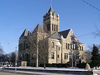
Pulaski County Courthouse in Winamac
|
|

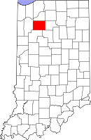
Location in the state of Indiana
|
|

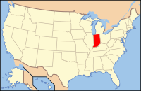
Indiana's location in the U.S.
|
|
| Country | |
| State | |
| Established | February 7, 1835 |
| Named for | Count Casimir Pulaski |
| County seat | Winamac |
| Largest town | Winamac (population and total area) |
| Incorporated Municipalities |
Four towns
|
| Government | |
| • Type | County |
| • Body | Board of Commissioners |
| Area | |
| • Total | 434.53 sq mi (1,125.4 km2) |
| • Land | 433.65 sq mi (1,123.1 km2) |
| • Water | 0.88 sq mi (2.3 km2) |
| Area rank | 25th largest county in Indiana |
| Elevation | 705 ft (215 m) |
| Population
(2020)
|
|
| • Total | 12,514 |
| • Estimate
(2023)
|
12,385 |
| • Rank | 83rd largest county in Indiana |
| • Density | 28.7989/sq mi (11.1193/km2) |
| Time zone | UTC-5 (Eastern) |
| • Summer (DST) | UTC-4 (Eastern) |
| ZIP Codes |
46366, 46374, 46511, 46939, 46960, 46978, 46985, 46996, 47946, 47957, 47959-60
|
| Area code | 574 |
| Congressional district | 2nd |
| Indiana Senate districts | 5th and 18th |
| Indiana House of Representatives districts | 16th and 20th |
| FIPS code | 18-131 |
| GNIS feature ID | 0446852 |
| U.S. and State Routes | |
| Airport | Arens Field
|
| Waterway | Tippecanoe River |
| Website | www.pulaskionline.org |
|
|
Pulaski County (pronounced pə-LAS-ky) is a county in the state of Indiana, U.S.. It's named after Count Casimir Pulaski, a hero from the American Revolutionary War. The main town and county seat is Winamac. In 2020, about 12,514 people lived here.
Contents
History of Pulaski County
Pulaski County was officially created in 1835. This means it became a recognized county with its own government and boundaries.
Geography of Pulaski County
Pulaski County covers a total area of about 434.53 square miles. Most of this area, about 433.65 square miles, is land. Only a small part, about 0.88 square miles, is water.
Major Roads and Highways
These important roads help people travel through Pulaski County:
 U.S. Route 35
 U.S. Route 421
 Indiana State Road 14
 Indiana State Road 39
 Indiana State Road 114
 Indiana State Road 119
 Indiana State Road 143
Railroads in the County
- CSX Transportation is a major railroad company that operates in the county.
Nearby Counties
Pulaski County shares borders with these other counties:
- Starke County (to the north)
- Marshall County (to the northeast)
- Fulton County (to the east)
- Cass County (to the southeast)
- White County (to the south)
- Jasper County (to the west)
Towns and Communities
Pulaski County has several towns and smaller communities where people live.
Towns in Pulaski County
These are the main towns in Pulaski County, with their populations from 2010:
- Francesville – 879 people
- Medaryville – 614 people
- Monterey – 218 people
- Winamac – 2,490 people (This is the largest town.)
Census-Designated Places
A census-designated place (CDP) is a community that looks like a town but isn't officially incorporated as one.
- Star City – 377 people
Other Small Communities
These are smaller, unincorporated places in the county:
Townships in Pulaski County
Pulaski County is divided into 12 smaller areas called townships. Each township has its own local government. Here are the townships and their populations from 2010:
- Beaver – 516 people
- Cass – 878 people
- Franklin – 715 people
- Harrison – 628 people
- Indian Creek – 691 people
- Jefferson – 545 people
- Monroe – 4,019 people
- Rich Grove – 921 people
- Salem – 1,399 people
- Tippecanoe – 1,104 people
- Van Buren – 911 people
- White Post – 1,075 people
Education in Pulaski County
Schools in Pulaski County are managed by four different school districts:
- Eastern Pulaski Community Schools
- West Central School Corporation
- Culver Community Schools
- North Judson-San Pierre Schools
High Schools
- Winamac Community High School
- West Central High School
Middle Schools
- Winamac Community Middle School
- West Central Middle School
Elementary Schools
- Eastern Pulaski Elementary School
- West Central Elementary School
Healthcare Facilities
- Pulaski Memorial Hospital in Winamac is the main hospital, with 25 beds for patients.
Climate and Weather Patterns
| Weather chart for Winamac, Indiana | |||||||||||||||||||||||||||||||||||||||||||||||
|---|---|---|---|---|---|---|---|---|---|---|---|---|---|---|---|---|---|---|---|---|---|---|---|---|---|---|---|---|---|---|---|---|---|---|---|---|---|---|---|---|---|---|---|---|---|---|---|
| J | F | M | A | M | J | J | A | S | O | N | D | ||||||||||||||||||||||||||||||||||||
|
1.9
31
14
|
1.7
36
18
|
2.7
47
28
|
3.5
60
38
|
3.8
72
50
|
4.1
80
59
|
3.9
84
63
|
3.9
82
61
|
3.3
75
53
|
2.9
64
42
|
3.1
49
31
|
2.6
36
20
|
||||||||||||||||||||||||||||||||||||
| temperatures in °F precipitation totals in inches source: The Weather Channel |
|||||||||||||||||||||||||||||||||||||||||||||||
|
Metric conversion
|
|||||||||||||||||||||||||||||||||||||||||||||||
The weather in Winamac changes throughout the year. In January, the average low temperature is about 14°F (about -10°C). In July, the average high temperature is about 84°F (about 29°C). The lowest temperature ever recorded was -29°F (-34°C) in January 1985. The highest was 102°F (39°C) in June 1988. The county gets the most rain in June, with about 4.09 inches (10.4 cm). February is usually the driest month.
Population and People
| Historical population | |||
|---|---|---|---|
| Census | Pop. | %± | |
| 1840 | 561 | — | |
| 1850 | 2,595 | 362.6% | |
| 1860 | 5,711 | 120.1% | |
| 1870 | 7,801 | 36.6% | |
| 1880 | 9,851 | 26.3% | |
| 1890 | 11,233 | 14.0% | |
| 1900 | 14,033 | 24.9% | |
| 1910 | 13,312 | −5.1% | |
| 1920 | 12,385 | −7.0% | |
| 1930 | 11,195 | −9.6% | |
| 1940 | 12,056 | 7.7% | |
| 1950 | 12,493 | 3.6% | |
| 1960 | 12,837 | 2.8% | |
| 1970 | 12,534 | −2.4% | |
| 1980 | 13,258 | 5.8% | |
| 1990 | 12,643 | −4.6% | |
| 2000 | 13,755 | 8.8% | |
| 2010 | 13,402 | −2.6% | |
| 2020 | 12,514 | −6.6% | |
| 2023 (est.) | 12,385 | −7.6% | |
| U.S. Decennial Census 1790-1960 1900-1990 1990-2000 2010 |
|||
In 2010, there were 13,402 people living in Pulaski County. The population density was about 30.9 people per square mile. Most people in the county are white (97.2%). About 0.7% are Black or African American, and 0.3% are American Indian. People of Hispanic or Latino background made up 2.4% of the population. The average age of people living in Pulaski County was 41.7 years old.
| Demographic | Proportion |
|---|---|
| White | 97.2% |
| Black | 0.7% |
| Asian | 0.2% |
| Islander | 0.0% |
| Native | 0.3% |
| Other | 1.6% |
| Hispanic (any race) |
2.4% |
See also
 In Spanish: Condado de Pulaski (Indiana) para niños
 | Janet Taylor Pickett |
 | Synthia Saint James |
 | Howardena Pindell |
 | Faith Ringgold |

