White County, Indiana facts for kids
Quick facts for kids
White County
|
|
|---|---|

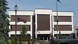
White County Courthouse in Monticello
|
|

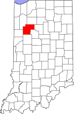
Location within the U.S. state of Indiana
|
|
 Indiana's location within the U.S. |
|
| Country | |
| State | |
| Founded | February 1, 1834 (authorized) |
| Named for | Isaac White |
| Seat | Monticello |
| Largest city | Monticello |
| Area | |
| • Total | 508.68 sq mi (1,317.5 km2) |
| • Land | 505.12 sq mi (1,308.3 km2) |
| • Water | 3.56 sq mi (9.2 km2) 0.70%% |
| Population
(2020)
|
|
| • Total | 24,688 |
| • Estimate
(2023)
|
24,917 |
| • Density | 48.5335/sq mi (18.7389/km2) |
| Time zone | UTC−5 (Eastern) |
| • Summer (DST) | UTC−4 (EDT) |
| Congressional district | 4th |
| Indiana county number 91 | |
White County is a county located in the state of Indiana, United States. In 2020, about 24,688 people lived here. The main town and county seat is Monticello. It is the only official city in White County.
Contents
History of White County
The first European settlers arrived in the area that would become White County around 1829. They settled west of the Tippecanoe River. More settlers came to other parts of the county by 1831. At that time, this land was part of Carroll County.
How White County Was Created
By 1833, many people had moved into the area. They asked the state government to create a new, separate county. On February 1, 1834, the state officially approved the new county. They decided to name it after Isaac White.
Who Was Isaac White?
Isaac White was a colonel in the Illinois militia, which was a type of local army. He was also a mining geologist, someone who studies rocks and minerals. He managed salt production in Equality, Illinois. White was a good friend of Governor William Henry Harrison of the Northwest Territory. He was also friends with Joseph Hamilton Daveiss, a U.S. District Attorney.
In 1811, Governor Harrison was planning to march on Tecumseh's village at Prophetstown. Isaac White joined the Indiana dragoons, a type of cavalry, as a private soldier. Both Isaac White and Joseph Hamilton Daveiss were killed during the Battle of Tippecanoe. They were buried together.
Setting Up the County Seat
Temporary leaders were chosen to organize the new county in the summer of 1834. Their job was to pick a county seat in September. On September 5, 1834, they chose Monticello as the future county seat. They picked Monticello because it was in the middle of the county. While the county was being set up, it was managed by Carroll County.
Changes to County Borders
White County's borders changed a few times after it was created. These changes happened on December 24, 1834, February 4, 1837, and February 14, 1839. Also, parts of White County were used to create other counties. These included Jasper (in 1837), Pulaski (in 1839), Newton (in 1839), and Benton (in 1840). The county's borders have stayed the same since 1840.
Geography of White County
White County has low, rolling hills. Most of the land is used for farming or for towns and cities. The Tippecanoe River flows south through the middle of the county. The highest point in the county is about 770 feet (235 meters) above sea level. This high point is a gentle hill located about 2.8 miles (4.5 km) southeast of Wolcott.
In 2010, the county covered a total area of about 508.68 square miles (1,317.5 km²). Most of this, about 505.12 square miles (1,308.2 km²), is land. The rest, about 3.56 square miles (9.2 km²), is water.
Neighboring Counties
White County shares borders with these counties:
- Pulaski County - to the north
- Cass County - to the east
- Carroll County - to the southeast
- Tippecanoe County - to the south
- Benton County - to the west
- Jasper County - to the northwest
Cities and Towns in White County
- Brookston (town)
- Burnettsville (town)
- Chalmers (town)
- Monon (town)
- Monticello (city and county seat)
- Reynolds (town)
- Wolcott (town)
Other Communities
These are places that are not officially cities or towns, but still have people living there:
Smaller Unincorporated Places
Townships in White County
A township is a small local government area. White County has these townships:
- Big Creek
- Cass
- Honey Creek
- Jackson
- Liberty
- Lincoln
- Monon
- Prairie
- Princeton
- Round Grove
- Union
- West Point
Main Roads and Highways
Railroads
- CSX Transportation
- Toledo, Peoria and Western Railway
Climate and Weather in White County
| Weather chart for Monticello, Indiana | |||||||||||||||||||||||||||||||||||||||||||||||
|---|---|---|---|---|---|---|---|---|---|---|---|---|---|---|---|---|---|---|---|---|---|---|---|---|---|---|---|---|---|---|---|---|---|---|---|---|---|---|---|---|---|---|---|---|---|---|---|
| J | F | M | A | M | J | J | A | S | O | N | D | ||||||||||||||||||||||||||||||||||||
|
2
33
17
|
1.9
39
21
|
2.9
51
31
|
3.5
64
40
|
3.9
74
50
|
4.1
83
60
|
4.2
86
63
|
4
84
61
|
2.9
78
53
|
2.7
66
42
|
3.1
51
33
|
2.7
38
23
|
||||||||||||||||||||||||||||||||||||
| temperatures in °F precipitation totals in inches source: The Weather Channel |
|||||||||||||||||||||||||||||||||||||||||||||||
|
Metric conversion
|
|||||||||||||||||||||||||||||||||||||||||||||||
In Monticello, the average temperature in January is about 17°F (-8°C). In July, the average high is about 86°F (30°C). The coldest temperature ever recorded was -25°F (-32°C) in January 1963. The hottest was 107°F (42°C) in July 1954.
The amount of rain and snow changes throughout the year. February usually gets the least precipitation, about 1.94 inches (49 mm). July gets the most, about 4.16 inches (106 mm).
Population and People
| Historical population | |||
|---|---|---|---|
| Census | Pop. | %± | |
| 1840 | 1,832 | — | |
| 1850 | 4,761 | 159.9% | |
| 1860 | 8,258 | 73.5% | |
| 1870 | 10,554 | 27.8% | |
| 1880 | 13,795 | 30.7% | |
| 1890 | 15,671 | 13.6% | |
| 1900 | 19,138 | 22.1% | |
| 1910 | 17,602 | −8.0% | |
| 1920 | 17,351 | −1.4% | |
| 1930 | 15,831 | −8.8% | |
| 1940 | 17,037 | 7.6% | |
| 1950 | 18,042 | 5.9% | |
| 1960 | 19,709 | 9.2% | |
| 1970 | 20,995 | 6.5% | |
| 1980 | 23,867 | 13.7% | |
| 1990 | 23,265 | −2.5% | |
| 2000 | 25,267 | 8.6% | |
| 2010 | 24,643 | −2.5% | |
| 2020 | 24,688 | 0.2% | |
| 2023 (est.) | 24,917 | 1.1% | |
| US Decennial Census 1790-1960 1900-1990 1990-2000 2010 |
|||
Population in 2010
According to the 2010 United States Census, White County had 24,643 people. There were 9,741 households, which are groups of people living together. About 6,849 of these were families. The population density was about 48.8 people per square mile. There were also 12,970 housing units, like houses or apartments.
Most people in the county were white (93.9%). About 3.7% were from other races, and 1.4% were from two or more races. People of Hispanic or Latino background made up 7.1% of the population.
When it came to ancestry (where people's families originally came from), many had German roots (27.0%). Others had Irish (13.3%), English (9.7%), or American (8.4%) ancestry.
Households and Income
In 2010, about 31.3% of households had children under 18 living with them. More than half (56.1%) were married couples. The average household had 2.50 people, and the average family had 2.96 people. The average age of people in the county was 41.9 years old.
The median income for a household was $47,697. This means half of the households earned more than this, and half earned less. For families, the median income was $52,626. The income per person in the county was $22,323. About 9.5% of all people in the county lived below the poverty line. This included 13.0% of those under 18 and 4.5% of those aged 65 or older.
Education in White County
Public schools in White County are managed by several different school groups. These include the Frontier School Corporation, North White School Corporation, Tri-County School Corporation, and Twin Lakes School Corporation.
High Schools and Middle Schools
- Tri-County Middle/Senior High School
- Frontier Junior-Senior High School
- North White High School
- North White Middle School
- Roosevelt Middle School
- Twin Lakes High School
Elementary Schools
- Eastlawn Elementary School
- Frontier Elementary School
- Meadowlawn Elementary School
- Monon Elementary School
- Oaklawn Elementary School
- Tri-County Intermediate School
See also
 In Spanish: Condado de White (Indiana) para niños
 | Toni Morrison |
 | Barack Obama |
 | Martin Luther King Jr. |
 | Ralph Bunche |

