Carroll County, Indiana facts for kids
Quick facts for kids
Carroll County
|
|
|---|---|

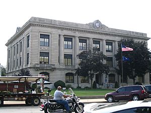
Carroll County courthouse in Delphi
|
|

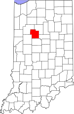
Location within the U.S. state of Indiana
|
|
 Indiana's location within the U.S. |
|
| Country | |
| State | |
| Founded | January 17, 1828 (authorized) April 28, 1828 (organized) |
| Named for | Charles Carroll of Carrollton |
| Seat | Delphi |
| Largest city | Delphi |
| Area | |
| • Total | 375.02 sq mi (971.3 km2) |
| • Land | 372.22 sq mi (964.0 km2) |
| • Water | 2.80 sq mi (7.3 km2) 0.75%% |
| Population
(2020)
|
|
| • Total | 20,306 |
| • Density | 54.1464/sq mi (20.9061/km2) |
| Time zone | UTC−5 (Eastern) |
| • Summer (DST) | UTC−4 (EDT) |
| Congressional district | 4th |
| Indiana county number 8 | |
Carroll County is a county in the state of Indiana. It is home to about 20,306 people, according to the 2020 United States Census. The main town and county seat is Delphi. Carroll County is also part of the larger Lafayette Metropolitan Statistical Area.
Contents
History of Carroll County
The area that is now Indiana was once part of the Northwest Territory, created by the United States in 1787. Later, in 1800, it became the Indiana Territory. William Henry Harrison was the first governor. Indiana officially became a state in December 1816.
Over time, the United States gained land from Native American tribes through agreements and treaties. Two important treaties, the Treaty of St. Mary's in 1818 and the Treaty of Mississinewas in 1826, made much of the land in future Carroll County available for new settlers.
People started moving to this area around 1824. Because more and more people arrived, the state decided to create Carroll County. This happened on January 17, 1828. The county was named after Charles Carroll of Carrollton, who was the last person to sign the Declaration of Independence.
The first county government started on April 28, 1828. They chose a spot for the county seat, which is the main town where the government offices are. They first thought of naming it 'Carrollton,' but instead, they picked 'Delphi.'
A very important part of the county's history is the Wabash and Erie Canal. This canal was built through the county in 1840. It was used for transportation and trade until the early 1870s.
The Carroll County Courthouse
The first building for the county court was built in 1831. It was later replaced by a brick building in 1856. A large 730-pound bell from the first courthouse was made in 1836. This bell was used in the second courthouse until 1916. It even sank in the Ohio River once while being moved, but it was recovered and returned to Carroll County in 1967.
The current courthouse was designed by Jaxson Cowell. It was built between 1916 and 1917. The outside of the building looks simple. But inside, it is very fancy. It has a beautiful stained glass dome and a mosaic tile floor.
Geography of Carroll County
The Wabash River flows through the northern part of Carroll County. The Tippecanoe River flows through the western side. Both rivers eventually join up in nearby Tippecanoe County. Wildcat Creek drains the southern part of the county.
Long ago, Carroll County was mostly covered in forests. Today, many flat areas are used for farming or towns. Only the areas around the rivers and creeks are still wooded. The highest point in the county is about 830 feet (253 meters) above sea level, located in the southeast corner.
Carroll County covers a total area of about 375 square miles. Most of this (about 372 square miles) is land. The rest (about 2.8 square miles) is water.
Neighboring Counties
- Cass County − northeast
- Howard County − east
- Clinton County − south
- Tippecanoe County − southwest
- White County − northwest
Cities and Towns
- Delphi (the county seat)
Towns
Small Communities
- Adams Mill
- Bringhurst
- Burrows
- Carrollton
- Cutler
- Deer Creek
- Lexington
- Lockport
- Ockley
- Owasco
- Patton
- Pittsburg
- Prince William
- Pyrmont
- Radnor
- Rockfield
- Sharon
- Terrace Bay
- Wheeling
Townships
- Adams
- Burlington
- Carrollton
- Clay
- Deer Creek
- Democrat
- Jackson
- Jefferson
- Liberty
- Madison
- Monroe
- Rock Creek
- Tippecanoe
- Washington
Main Roads
Railroads
- Norfolk Southern Railway
- Winamac Southern Railway
Climate and Weather
| Weather chart for Delphi, Indiana | |||||||||||||||||||||||||||||||||||||||||||||||
|---|---|---|---|---|---|---|---|---|---|---|---|---|---|---|---|---|---|---|---|---|---|---|---|---|---|---|---|---|---|---|---|---|---|---|---|---|---|---|---|---|---|---|---|---|---|---|---|
| J | F | M | A | M | J | J | A | S | O | N | D | ||||||||||||||||||||||||||||||||||||
|
2
33
17
|
1.9
39
21
|
2.9
51
31
|
3.5
64
40
|
3.9
74
50
|
4.1
83
60
|
4.2
86
63
|
4
84
61
|
2.9
78
53
|
2.7
66
42
|
3.1
51
33
|
2.7
38
23
|
||||||||||||||||||||||||||||||||||||
| temperatures in °F precipitation totals in inches source: The Weather Channel |
|||||||||||||||||||||||||||||||||||||||||||||||
|
Metric conversion
|
|||||||||||||||||||||||||||||||||||||||||||||||
In Delphi, the average temperatures change throughout the year. In January, it's usually around 17°F (about -8°C). In July, it can get up to 86°F (about 30°C). The coldest temperature ever recorded was -25°F (-32°C) in January 1963. The hottest was 107°F (42°C) in July 1954. The amount of rain and snow also changes, with July usually being the wettest month.
People of Carroll County (Demographics)
| Historical population | |||
|---|---|---|---|
| Census | Pop. | %± | |
| 1830 | 1,611 | — | |
| 1840 | 7,819 | 385.4% | |
| 1850 | 11,015 | 40.9% | |
| 1860 | 13,489 | 22.5% | |
| 1870 | 16,152 | 19.7% | |
| 1880 | 18,345 | 13.6% | |
| 1890 | 20,021 | 9.1% | |
| 1900 | 19,953 | −0.3% | |
| 1910 | 17,970 | −9.9% | |
| 1920 | 16,315 | −9.2% | |
| 1930 | 15,049 | −7.8% | |
| 1940 | 15,410 | 2.4% | |
| 1950 | 16,010 | 3.9% | |
| 1960 | 16,934 | 5.8% | |
| 1970 | 17,734 | 4.7% | |
| 1980 | 19,722 | 11.2% | |
| 1990 | 18,809 | −4.6% | |
| 2000 | 20,165 | 7.2% | |
| 2010 | 20,155 | 0.0% | |
| 2020 | 20,306 | 0.7% | |
| 2023 (est.) | 20,525 | 1.8% | |
| US Decennial Census 1790-1960 1900-1990 1990-2000 2010 |
|||
As of the 2010 United States Census, there were 20,155 people living in Carroll County. There were about 7,900 households, with many being families. The population density was about 54 people per square mile. Most people (96.8%) were white. About 3.5% of the population was of Hispanic or Latino origin. Many people had German, American, Irish, or English backgrounds.
The average age in the county was about 40.9 years old. About 32.1% of households had children under 18 living there. The average household had 2.54 people. The average family had 2.98 people.
The average income for a household was about $47,697. For families, it was about $60,420. About 9.4% of all people in the county lived below the poverty line. This included 11.0% of those under 18.
2020 Census Information
In the 2020 United States Census, the population of Carroll County was 20,306 people.
| Race | Num. | Perc. |
|---|---|---|
| White (NH) | 18,727 | 92.2% |
| Black or African American (NH) | 128 | 0.6% |
| Native American (NH) | 33 | 0.16% |
| Asian (NH) | 48 | 0.24% |
| Pacific Islander (NH) | 0 | 0% |
| Other/Mixed (NH) | 547 | 2.7% |
| Hispanic or Latino | 823 | 4.1% |
Education in Carroll County
Public schools in Carroll County are managed by different school districts:
- Carroll Consolidated School District
- Delphi Community School Corporation
- Rossville Consolidated School District
- Twin Lakes School Corporation
High schools and middle schools
- Delphi Community High School
- Delphi Community Middle School
- Carroll Consolidated School
Elementary schools
- Carroll Elementary School
- Delphi Community Elementary School
See also
 In Spanish: Condado de Carroll (Indiana) para niños
 | Valerie Thomas |
 | Frederick McKinley Jones |
 | George Edward Alcorn Jr. |
 | Thomas Mensah |

