Lafayette metropolitan area, Indiana facts for kids
Quick facts for kids
Greater Lafayette–West Lafayette
|
|
|---|---|
| Lafayette–West Lafayette, IN Metropolitan Statistical Area |
|

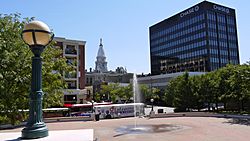
Downtown Lafayette and the Riehle Plaza and CityBus depot
|
|
| Country | |
| State | |
| Largest city | Lafayette |
| Other cities | - West Lafayette - Frankfort - Monticello |
| Time zone | UTC−05:00 (Eastern Standard Time) |
| • Summer (DST) | UTC−04:00 (Eastern Daylight Time) |
The Lafayette-West Lafayette, Indiana Metropolitan Statistical Area is a large area in Indiana, United States. It is defined by the United States Census Bureau. This area includes three counties and is centered around the cities of Lafayette and West Lafayette.
As of July 1, 2021, about 224,709 people lived in this metropolitan area. The population has been growing, with about 237,130 people in 2021. This shows a 16% growth since 2010, when the population was 210,297.
Contents
Counties in the Area
The Lafayette-West Lafayette Metropolitan Statistical Area includes these counties in Indiana:
Main Cities and Towns
This metropolitan area is home to several cities and towns. The two largest cities are considered the "principal cities" of the area.
Major Cities
- Lafayette: This is the largest city in the area.
- West Lafayette: This city is also a main center of the area.
Other Towns and Communities
Many smaller towns and communities are part of the Lafayette-West Lafayette metropolitan area. Some of these include:
- Battle Ground
- Dayton
- Delphi
- Flora
- Fowler
- Otterbein
- Oxford
- Shadeland
- Boswell
- Camden
- Clarks Hill
- Ambia
- Burlington
- Earl Park
- Yeoman
There are also many smaller, unincorporated places within the area. These are communities that do not have their own local government.
Population and People
In the year 2000, the area had 178,541 people living in 66,502 households. A household is a group of people living together in one home.
The median income for a household was $40,381. This means that half of the households earned more than this amount, and half earned less. For families, the median income was $49,625. The average income per person in the area was $18,677.
Lafayette–West Lafayette–Frankfort Combined Statistical Area
The Lafayette–West Lafayette–Frankfort Combined Statistical Area (CSA) is an even larger area. It includes six counties in Indiana. A Combined Statistical Area brings together different metropolitan and micropolitan areas that are closely linked.
As of the 2020 Census, this larger CSA had a population of 256,906 people. By July 1, 2021, the population was estimated to be around 257,774.
Parts of the Combined Statistical Area
The CSA is made up of one metropolitan area and two micropolitan areas:
- Metropolitan Statistical Area (MSA)
- Lafayette–West Lafayette (which includes Benton, Carroll, and Tippecanoe counties)
- Micropolitan Statistical Areas (μSA)
- Frankfort (Clinton County)
- Monticello (White County)
Images for kids
See also
 In Spanish: Área metropolitana de Lafayette (Indiana) para niños
 | Shirley Ann Jackson |
 | Garett Morgan |
 | J. Ernest Wilkins Jr. |
 | Elijah McCoy |


