Clinton County, Indiana facts for kids
Quick facts for kids
Clinton County
|
|
|---|---|

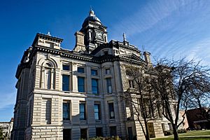
Clinton County Courthouse in Frankfort, Indianasq_mi
|
|

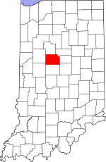
Location within the U.S. state of Indiana
|
|
 Indiana's location within the U.S. |
|
| Country | |
| State | |
| Founded | 1830 |
| Named for | DeWitt Clinton |
| Seat | Frankfort |
| Largest city | Frankfort |
| Area | |
| • Total | 405.25 sq mi (1,049.6 km2) |
| • Land | 405.07 sq mi (1,049.1 km2) |
| • Water | 0.18 sq mi (0.5 km2) 0.04%% |
| Population
(2020)
|
|
| • Total | 33,190 |
| • Estimate
(2023)
|
32,730 |
| • Density | 81.900/sq mi (31.622/km2) |
| Time zone | UTC−5 (Eastern) |
| • Summer (DST) | UTC−4 (EDT) |
| Congressional district | 4th |
| Indiana county number 12 | |
Clinton County is a place in Indiana, a state in the United States. It's like a district or region within the state. In 2020, about 33,190 people lived there. The main town and center of the county is Frankfort.
Contents
History of Clinton County
Clinton County officially started on March 1, 1830. It was named after DeWitt Clinton. He was the sixth Governor of New York State. DeWitt Clinton also helped create the Erie Canal. This canal was a big waterway that helped people travel and settle in the Midwest.
The idea to create Clinton County was approved on January 29, 1830. It was formed from the eastern parts of a nearby area called Tippecanoe County.
A brave soldier named Lieutenant General James F. Record grew up in Clinton County. He was recognized for his courage during the Vietnam War.
Geography and Nature
Clinton County covers about 405 square miles. Most of this area, about 405 square miles, is land. Only a very small part, about 0.18 square miles, is water.
Neighboring Counties
Clinton County shares its borders with these other counties:
- Carroll County (north)
- Howard County (northeast)
- Tipton County (east)
- Hamilton County (southeast)
- Boone County (south)
- Montgomery County (southwest)
- Tippecanoe County (west)
Cities and Towns
Here are the main cities and towns in Clinton County:
Smaller Communities
Clinton County also has many smaller, unincorporated towns. These are places that don't have their own local government.
- Antioch
- Avery
- Beard
- Boyleston
- Cambria
- Cyclone
- Edna Mills
- Fickle
- Forest
- Geetingsville
- Hamilton
- Hillisburg
- Jefferson
- Kilmore
- Manson
- Middlefork
- Moran
- Pickard
- Scircleville
- Sedalia
Past Settlements
Some towns that used to exist in Clinton County are now gone.
Local Divisions (Townships)
Counties in Indiana are divided into smaller areas called townships. Clinton County has these townships:
- Center
- Forest
- Jackson
- Johnson
- Kirklin
- Madison
- Michigan
- Owen
- Perry
- Ross
- Sugar Creek
- Union
- Warren
- Washington
Important Roads
Several major roads pass through Clinton County, helping people travel around.
 Interstate 65
 U.S. Route 52
 U.S. Route 421
 Indiana State Road 26
 Indiana State Road 28
 Indiana State Road 29
 Indiana State Road 38
 Indiana State Road 39
 Indiana State Road 75
Airport and Trains
The Frankfort Municipal Airport serves Clinton County. This airport helps people and goods travel by air.
Train lines also run through the county. These include:
- CSX Transportation
- Norfolk Southern Railway
Climate and Weather
| Weather chart for Frankfort, Indiana | |||||||||||||||||||||||||||||||||||||||||||||||
|---|---|---|---|---|---|---|---|---|---|---|---|---|---|---|---|---|---|---|---|---|---|---|---|---|---|---|---|---|---|---|---|---|---|---|---|---|---|---|---|---|---|---|---|---|---|---|---|
| J | F | M | A | M | J | J | A | S | O | N | D | ||||||||||||||||||||||||||||||||||||
|
2.1
32
16
|
2
38
20
|
3.2
49
30
|
3.6
61
39
|
4.1
72
50
|
4.5
81
59
|
4.1
84
63
|
4
82
61
|
3
76
53
|
2.9
64
42
|
3.4
50
33
|
2.9
37
22
|
||||||||||||||||||||||||||||||||||||
| temperatures in °F precipitation totals in inches source: The Weather Channel |
|||||||||||||||||||||||||||||||||||||||||||||||
|
Metric conversion
|
|||||||||||||||||||||||||||||||||||||||||||||||
The weather in Frankfort, the main town, changes throughout the year. In January, the average low temperature is about 16°F (around -9°C). In July, the average high temperature is about 84°F (around 29°C).
The coldest temperature ever recorded was -26°F (-32°C) in December 1983. The hottest was 105°F (41°C) in July 1980. The county usually gets the most rain in June and the least in February.
People of Clinton County
| Historical population | |||
|---|---|---|---|
| Census | Pop. | %± | |
| 1830 | 1,423 | — | |
| 1840 | 7,508 | 427.6% | |
| 1850 | 11,869 | 58.1% | |
| 1860 | 14,505 | 22.2% | |
| 1870 | 17,330 | 19.5% | |
| 1880 | 23,472 | 35.4% | |
| 1890 | 27,370 | 16.6% | |
| 1900 | 28,202 | 3.0% | |
| 1910 | 26,674 | −5.4% | |
| 1920 | 27,737 | 4.0% | |
| 1930 | 27,329 | −1.5% | |
| 1940 | 28,411 | 4.0% | |
| 1950 | 29,734 | 4.7% | |
| 1960 | 30,765 | 3.5% | |
| 1970 | 30,547 | −0.7% | |
| 1980 | 31,545 | 3.3% | |
| 1990 | 30,974 | −1.8% | |
| 2000 | 33,866 | 9.3% | |
| 2010 | 33,224 | −1.9% | |
| 2020 | 33,190 | −0.1% | |
| 2023 (est.) | 32,730 | −1.5% | |
| U.S. Decennial Census 1790-1960 1900-1990 1990-2000 2010 |
|||
In 2010, there were about 33,224 people living in Clinton County. Most people (about 91%) were white. About 13.2% of the population was of Hispanic or Latino background. Many families lived in the county, with about 36% of households having children under 18. The average age of people living there was about 37.5 years old.
Population in 2020
The 2020 United States Census showed that Clinton County had 33,190 people.
| Race | Number of People | Percentage |
|---|---|---|
| White (not Hispanic) | 25,808 | 77.7% |
| Black or African American (not Hispanic) | 196 | 0.6% |
| Native American (not Hispanic) | 62 | 0.2% |
| Asian (not Hispanic) | 70 | 0.2% |
| Pacific Islander (not Hispanic) | 13 | 0.04% |
| Other/Mixed (not Hispanic) | 899 | 2.7% |
| Hispanic or Latino | 6,142 | 18.5% |
See also
 In Spanish: Condado de Clinton (Indiana) para niños
 | Frances Mary Albrier |
 | Whitney Young |
 | Muhammad Ali |

