Montgomery County, Indiana facts for kids
Quick facts for kids
Montgomery County
|
||
|---|---|---|

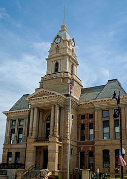
County Courthouse in Crawfordsville
|
||
|
||

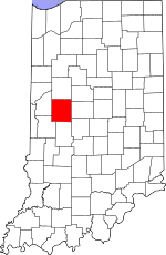
Location within the U.S. state of Indiana
|
||
 Indiana's location within the U.S. |
||
| Country | ||
| State | ||
| Founded | December 21, 1822 (authorized) March 1, 1823 (organized) |
|
| Named for | Richard Montgomery | |
| Seat | Crawfordsville | |
| Largest city | Crawfordsville | |
| Area | ||
| • Total | 505.44 sq mi (1,309.1 km2) | |
| • Land | 504.61 sq mi (1,306.9 km2) | |
| • Water | 0.83 sq mi (2.1 km2) 0.16%% | |
| Population
(2020)
|
||
| • Total | 37,936 | |
| • Density | 75.18/sq mi (29.03/km2) | |
| Time zone | UTC−5 (Eastern) | |
| • Summer (DST) | UTC−4 (EDT) | |
| Congressional district | 4th | |
| Indiana county number 54 | ||
Montgomery County is a county in the state of Indiana, USA. In 2020, about 37,936 people lived here. Its main city and county seat is Crawfordsville. The county is split into eleven areas called townships. These townships help provide local services to the people living there.
Montgomery County is part of the Crawfordsville, IN Micropolitan Statistical Area. This means it's a smaller city area that is important to the region.
Contents
History of Montgomery County
Early History and First Settlers
Long ago, the first known people in this area were the Mound Builders. These Native Americans built large mounds from earth. Some thought two mounds in Franklin Township were built by them. But later research showed they were probably natural hills. Other Native American tribes lived here until the early 1830s.
The first European-American settler was William Offield. He came in 1821 with his family from Tennessee. They settled near Offield Creek and Sugar Creek. This spot was about 5 miles (8 km) southwest of where Crawfordsville is today. The first land bought from the government was in Scott Township in 1822. Many more pieces of land were bought soon after. Most early settlers came from Kentucky and Ohio. Others arrived from Tennessee, Virginia, and the Carolinas.
Montgomery County was officially created on December 21, 1822. The state of Indiana decided its borders and how its government would work. It was named after Richard Montgomery. He was an American general who died in 1775 during the American Revolutionary War. The first county election was held on March 1, 1823. Sixty-one people voted to choose the first county leaders. These leaders then decided to build the first jail and courthouse.
In 1824, a big land sale happened in Crawfordsville. Many areas of land were sold at an auction. The money from this sale, mostly gold and silver, was put into barrels. It was then taken by wagon to Louisville. From there, it traveled by boat to Washington, D.C. More people moved to the county the next year.
Courthouses of Montgomery County
Montgomery County's first courthouse was ordered in 1823. It was made of strong logs and had two stories. It cost $295 to build and was finished in August 1824. Later, in 1825, someone was hired to clean up around the courthouse. This was so that "hogs would not find a comfortable place in which to make their beds."
A bigger courthouse was built starting in 1831. This one was made of brick and had two stories. It was finished in 1833. Later, smaller buildings were added next to it. This brick courthouse stood until 1875.
The third and current courthouse was designed by George W. Bunting. He was an architect from Indianapolis. This courthouse is one of six he designed in Indiana that are still standing. The building was finished in 1876. It cost $150,000 to build.
Inside the cornerstone of the current courthouse is a special copper box. It holds important items from the past. These include the key to the old courthouse and an old coin.
Geography of Montgomery County
Montgomery County has gentle, rolling hills. Most of the land is used for farming or for towns. Sugar Creek flows through the middle of the county, heading southwest. The highest point in the county is near New Ross. It is about 930 feet (283 meters) above sea level.
The county covers about 505.44 square miles (1,309.1 km²). Most of this, about 504.61 square miles (1,306.9 km²), is land. Only a small part, about 0.83 square miles (2.1 km²), is water.
Counties Nearby
- Tippecanoe - north
- Clinton - northeast
- Boone - east
- Hendricks - southeast
- Putnam - south
- Parke - southwest
- Fountain - west
Cities and Towns
- Crawfordsville (the county seat)
Other Communities
- Lake Holiday (a census-designated place)
- Ames
- Balhinch
- Beckville
- Bowers
- Browns Valley
- Cherry Grove
- Darlington Woods
- Deer's Mill
- Elmdale
- Fiskville
- Garfield
- Hibernia
- Kirkpatrick
- Lapland
- Linnsburg
- Mace
- Manchester
- North Union
- Parkersburg
- Shannondale
- Smartsburg
- Taylor Corner
- Wesley
- Whitesville
- Yountsville
Old Towns No Longer Existing
- Binford
- Fredericksburg
- Troutman
Townships in Montgomery County
- Brown
- Clark
- Coal Creek
- Franklin
- Madison
- Ripley
- Scott
- Sugar Creek
- Union
- Walnut
- Wayne
Protected Natural Areas
- Shades State Park (partly in Parke and Fountain counties too)
Transportation in Montgomery County
Main Roads
Railroads
- CSX Transportation (a large freight railroad company)
Airport
- KCFJ - Crawfordsville Regional Airport
The Crawfordsville Regional Airport (KCFJ) serves Montgomery County. It is located four miles (6.4 km) south-southwest of Crawfordsville. The airport has about 6,400 flights each year. Most of these are small private planes. It has a 4,504-foot (1,373 m) asphalt runway.
Historic Bridges
Two old covered bridges are found in the county. These are the Darlington and the Deer's Mill bridges. They are interesting historical landmarks.
Climate and Weather
| Weather chart for Crawfordsville, Indiana | |||||||||||||||||||||||||||||||||||||||||||||||
|---|---|---|---|---|---|---|---|---|---|---|---|---|---|---|---|---|---|---|---|---|---|---|---|---|---|---|---|---|---|---|---|---|---|---|---|---|---|---|---|---|---|---|---|---|---|---|---|
| J | F | M | A | M | J | J | A | S | O | N | D | ||||||||||||||||||||||||||||||||||||
|
2.1
33
14
|
2
39
19
|
3.2
50
27
|
3.7
61
38
|
4.1
72
48
|
4.3
82
58
|
3.8
85
62
|
4
83
59
|
3.4
78
51
|
2.8
65
39
|
3.8
51
31
|
2.6
38
20
|
||||||||||||||||||||||||||||||||||||
| temperatures in °F precipitation totals in inches source: The Weather Channel |
|||||||||||||||||||||||||||||||||||||||||||||||
|
Metric conversion
|
|||||||||||||||||||||||||||||||||||||||||||||||
In Crawfordsville, the average temperature in January is about 14°F (-10°C). In July, it's around 85°F (29°C). The coldest temperature ever recorded was -31°F (-35°C) in January 1994. The hottest was 102°F (39°C) in June 1988. The county gets about 2 to 4 inches (5 to 10 cm) of rain each month. June usually has the most rain.
Education in Montgomery County
Schools for Kids (K-12)
There are several school districts in Montgomery County. These include:
- Crawfordsville Community Schools
- North Montgomery Community School Corporation
- South Montgomery Community School Corporation
Libraries and Museums
Montgomery County has several Carnegie libraries. These libraries were built in the early 1900s with money from Andrew Carnegie. Most of them are still used as libraries today. The Crawfordsville District Public Library moved to a new building in 2005. Its old building is now the Carnegie Museum of Montgomery County. This museum teaches about the history of Montgomery County. Other Carnegie libraries are in Waveland, Darlington, and Linden.
Population and People
| Historical population | |||
|---|---|---|---|
| Census | Pop. | %± | |
| 1830 | 7,317 | — | |
| 1840 | 14,438 | 97.3% | |
| 1850 | 18,084 | 25.3% | |
| 1860 | 20,888 | 15.5% | |
| 1870 | 23,765 | 13.8% | |
| 1880 | 27,316 | 14.9% | |
| 1890 | 28,025 | 2.6% | |
| 1900 | 29,388 | 4.9% | |
| 1910 | 29,296 | −0.3% | |
| 1920 | 28,490 | −2.8% | |
| 1930 | 26,980 | −5.3% | |
| 1940 | 27,231 | 0.9% | |
| 1950 | 29,122 | 6.9% | |
| 1960 | 32,089 | 10.2% | |
| 1970 | 33,930 | 5.7% | |
| 1980 | 35,501 | 4.6% | |
| 1990 | 34,436 | −3.0% | |
| 2000 | 37,629 | 9.3% | |
| 2010 | 38,124 | 1.3% | |
| 2020 | 37,936 | −0.5% | |
| 2023 (est.) | 38,573 | 1.2% | |
| US Decennial Census 1790-1960 1900-1990 1990-2000 2010-2013 |
|||
In 2010, there were 38,124 people living in Montgomery County. Most people (95.2%) were white. About 4.6% of the population was of Hispanic or Latino background. Many people had German, American, Irish, or English family roots. The average age of people in the county was about 39.4 years old.
See also
 In Spanish: Condado de Montgomery (Indiana) para niños
 | Calvin Brent |
 | Walter T. Bailey |
 | Martha Cassell Thompson |
 | Alberta Jeannette Cassell |


