Parke County, Indiana facts for kids
Quick facts for kids
Parke County
|
|
|---|---|
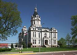
Parke County courthouse in Rockville, Indiana
|
|
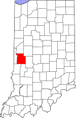
Location within the U.S. state of Indiana
|
|
 Indiana's location within the U.S. |
|
| Country | |
| State | |
| Founded | 1821 |
| Named for | Benjamin Parke |
| Seat | Rockville |
| Largest town | Rockville |
| Area | |
| • Total | 449.98 sq mi (1,165.4 km2) |
| • Land | 444.66 sq mi (1,151.7 km2) |
| • Water | 5.32 sq mi (13.8 km2) 1.18%% |
| Population
(2020)
|
|
| • Total | 16,156 |
| • Density | 35.9038/sq mi (13.8625/km2) |
| Time zone | UTC−5 (Eastern) |
| • Summer (DST) | UTC−4 (EDT) |
| Congressional district | 8th |
| Indiana county number 61 | |
Parke County is located in the western part of the U.S. state of Indiana. It sits along the Wabash River. This county was formed in 1821 from a part of Vigo County. In 2020, about 16,156 people lived here. The main town, or county seat, is Rockville.
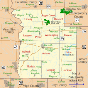
Parke County has a population density of about 39 people per square mile. It includes six towns and many smaller communities. The county is divided into 13 townships that help provide local services.
Several major roads and one railroad line pass through Parke County.
Parke County is famous for its 31 covered bridges. It is often called the 'Covered Bridge Capital of the World'. Each October, the county hosts the Parke County Covered Bridge Festival.
Contents
History of Parke County
For thousands of years, different groups of indigenous peoples lived in this area. The first European settlers were French-Canadian colonists. They founded Vincennes in 1703, in the western part of Indiana.
After the Seven Years' War, France gave its North American land to Great Britain. Then, after the American Revolutionary War, Great Britain gave this land to the new United States. This included land where Native American nations lived.
In 1811, the Shawnee chief Tecumseh brought several tribes together. They wanted to stop European-American settlers from moving into their lands. General William Henry Harrison led an army from Vincennes to fight the Native Americans. This was the Battle of Tippecanoe in late 1811. Zachariah Cicott was a scout for Harrison's army. Cicott had traded with Native Americans along the Wabash River since about 1801. Harrison's army marched through the area that later became Parke County. The town of Armiesburg in Wabash Township got its name because Harrison's army camped nearby.
Parke County was officially formed on January 9, 1821. It was created from a part of Vigo County. The county was named after Captain Benjamin Parke. He led a group of soldiers called Dragoons at the Battle of Tippecanoe. Parke was also a delegate for Indiana Territory in the U.S. Congress. In 1821, he became a U.S. District Judge for Indiana.
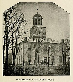
The first county seat was Roseville, then it moved to Armiesburg. In 1822, Rockville became the permanent county seat. The state law said county buildings should start within one year. But construction didn't begin until 1824. The first courthouse was finished in Rockville in 1826. This log building was also used as a church.
In 1832, a brick building replaced the log courthouse. This brick courthouse was used for over 40 years, until 1879. It was then torn down to build a new stone courthouse. The architects for this new building were Thomas J. Tolan and his son Brentwood. They designed many courthouses in Indiana and other states.
The new courthouse in Rockville was finished in 1882. It cost about $79,000. Items like town history documents, coins, and photographs were placed in its cornerstone. A special ceremony took place on February 22, 1882. This was George Washington's birthday. The clock and bell were added later for about $1,500.
The Wabash and Erie Canal was completed through the area around 1850. It ran through Parke County on the east side of the Wabash River. The canal served several towns along the river until it closed in the 1870s.
Geography and Nature
Parke County is in western Indiana. It is about halfway between the state's northern and southern borders. To the north is Fountain County. To the east are Montgomery County and Putnam County. To the south are Clay County and Vigo County. The Wabash River forms the county's western border. Across the river is Vermillion County. The state capital, Indianapolis, is about 60 miles to the east.
All of Parke County's water drains into the Wabash River. The land north of Rockville is gently rolling. This was formed by the Wisconsinan ice age. A ridge called the Shelbyville moraine divides this from the flat land in the south.
Turkey Run State Park is in northern Parke County. It was one of Indiana's first state parks. It covers 2,382 acres of land. The county also has part of Shades State Park. This park is 3,082 acres and is about 5 miles northeast of Turkey Run. Most of Shades State Park is in Montgomery County.
Parke County covers a total area of about 450 square miles. About 445 square miles (98.82%) is land, and 5.32 square miles (1.18%) is water.
Towns and Communities
Parke County has six main towns. The largest is Rockville, with about 2,600 people. It's in the center of the county and is the county seat. Bloomingdale is about 5 miles northwest of Rockville, with 335 people. To the northeast of Rockville is Marshall, with 324 people.
Southwest of Rockville, Mecca has 335 people. Montezuma is on the far western edge of the county, with 1,022 people. Finally, Rosedale is near the southern border, with 725 people.
Census-Designated Places
These are smaller communities that are recognized for census purposes.
Townships
Parke County is divided into 13 townships:
- Adams
- Florida
- Greene
- Howard
- Jackson
- Liberty
- Penn
- Raccoon
- Reserve
- Sugar Creek
- Union
- Wabash
- Washington
Unincorporated Communities
These are smaller settlements without their own local government.
- Alma Lake
- Annapolis
- Arabia
- Armiesburg
- Banner Mills
- Bellmore
- Bethany
- Bradfield Corner
- Byron
- Catlin
- Cincinnati
- Coloma
- Coxville
- Diamond
- Ferndale
- Grange Corner
- Guion
- Hollandsburg
- Howard
- Hudnut
- Jessup
- Keytsville‡
- Klondyke
- Leatherwood
- Lena
- Lodi
- Lusks Mills
- Madalline
- Mansfield
- Midway
- Milligan
- Minshall
- New Discovery
- Numa
- Nyesville
- Parkeville
- Piattsville
- Pin Hook
- Rockport
- Smockville
- Snow Hill
- Stumptown
- Superior
- Sylvania
- Tangier
- Vivalia‡
- West Atherton
- West Melcher
- West Union
Ghost Town
- Coke Oven Hollow
Transportation in Parke County
Two major U.S. highways cross the county. U.S. Route 36 goes east-west through the middle. It enters from Putnam County, passes through Rockville and Montezuma, then goes into Vermillion County. U.S. Route 41 comes from Fountain County in the north. It meets U.S. Route 36 in Rockville. Then it goes southwest towards Clinton and south to Vigo County.
Several Indiana State Roads also run through Parke County. Indiana State Road 47 starts at U.S. Route 41 in the north and goes east. Indiana State Road 59 enters from Clay County in the south. It runs north through the eastern part of the county. Indiana State Road 163 is a short road in Parke County. It crosses the river at Clinton. Indiana State Road 234 enters from Cayuga in the far northwest.
A small part of a major CSX Transportation railroad line passes through the southwest corner. Another CSX line enters the far southeastern corner.
Climate and Weather
| Weather chart for Rockville, Indiana | |||||||||||||||||||||||||||||||||||||||||||||||
|---|---|---|---|---|---|---|---|---|---|---|---|---|---|---|---|---|---|---|---|---|---|---|---|---|---|---|---|---|---|---|---|---|---|---|---|---|---|---|---|---|---|---|---|---|---|---|---|
| J | F | M | A | M | J | J | A | S | O | N | D | ||||||||||||||||||||||||||||||||||||
|
2.5
36
19
|
2.3
42
24
|
3.7
54
33
|
4.1
66
43
|
4.8
76
52
|
4.3
84
61
|
4.9
87
65
|
4.5
85
63
|
3.1
79
56
|
3.1
68
45
|
4.3
53
36
|
3.5
40
25
|
||||||||||||||||||||||||||||||||||||
| temperatures in °F precipitation totals in inches source: The Weather Channel |
|||||||||||||||||||||||||||||||||||||||||||||||
|
Metric conversion
|
|||||||||||||||||||||||||||||||||||||||||||||||
In Rockville, average temperatures range from 19°F in January to 87°F in July. The coldest temperature ever recorded was -25°F in January 1994. The hottest was 109°F in July 1936. The average monthly rainfall is between 2.25 inches in February and 4.89 inches in July.
Between 1950 and 2009, eight tornadoes were reported in Parke County. No one was hurt or killed by these tornadoes.
Notable People from Parke County
Warder Clyde Allee
Warder Clyde Allee was born in Bloomingdale in 1885. He studied zoology and ecology. He earned his Ph.D. in 1912. He taught, did research, and wrote many books. He discovered what is now called the Allee effect, which describes how groups of animals can help each other survive. He passed away in Florida in 1955.
Gordon Allport
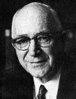
Gordon Allport was born in Montezuma in 1897. When he was six, his family moved to Ohio. He studied psychology at Harvard University. He earned his Ph.D. in 1922. He focused on personality traits. He started teaching at Harvard in 1924 and wrote many important works. He passed away in Massachusetts in 1967.
William Henry Harrison Beadle
William Henry Harrison Beadle was born in a log cabin in Parke County in 1838. He chose to use money for his education instead of a farm. He studied civil engineering at the University of Michigan. He fought in the Civil War for the Union army and became a brigadier general. Later, he became president of Madison State Normal School. He passed away in 1915.
Mordecai Brown
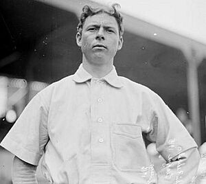
The famous Baseball player Mordecai Brown was born in Nyesville, Parke County, on October 19, 1876. He lost parts of two fingers on his right hand in a farm accident. This led to his nickname "Three Finger." He was also called "Miner" because he worked in coal mines before playing baseball. He started in the major leagues in 1903 and retired in 1916. He passed away in 1948.
Grover Jones
Grover Jones was born in Rosedale in 1893. He grew up near Terre Haute. He became a short story writer, screenwriter, and film director. He wrote for over 100 films. He passed away in Hollywood, California, in 1940.
Knute Cauldwell
Knute Cauldwell was born in Parke County. He played in the early years of the National Football League.
Local Media
The first newspaper in Parke County was The Wabash Herald, started in 1829. Over time, it was sold and renamed many times. It became The Rockville Intelligencer, The Olive Branch, The Parke County Whig, and The Rockville Republican. Other newspapers also started and stopped. As of 1912, several papers were published. These included the Republican, the Tribune, the Montezuma Enterprise, and the Bloomingdale World. Papers were also printed in Rosedale and Marshall. The original Wabash Herald still exists today. Since 1977, it has been called the Parke County Sentinel.
Population Changes Over Time
| Historical population | |||
|---|---|---|---|
| Census | Pop. | %± | |
| 1830 | 7,535 | — | |
| 1840 | 13,499 | 79.2% | |
| 1850 | 14,968 | 10.9% | |
| 1860 | 15,538 | 3.8% | |
| 1870 | 18,166 | 16.9% | |
| 1880 | 19,460 | 7.1% | |
| 1890 | 20,296 | 4.3% | |
| 1900 | 23,000 | 13.3% | |
| 1910 | 22,214 | −3.4% | |
| 1920 | 18,875 | −15.0% | |
| 1930 | 16,561 | −12.3% | |
| 1940 | 17,358 | 4.8% | |
| 1950 | 15,674 | −9.7% | |
| 1960 | 14,804 | −5.6% | |
| 1970 | 14,600 | −1.4% | |
| 1980 | 16,372 | 12.1% | |
| 1990 | 15,410 | −5.9% | |
| 2000 | 17,241 | 11.9% | |
| 2010 | 17,339 | 0.6% | |
| 2020 | 16,156 | −6.8% | |
| 2023 (est.) | 16,484 | −4.9% | |
| U.S. Decennial Census 1790-1960 1900-1990 1990-2000 2010 |
|||
In 2010, there were 17,339 people living in Parke County. There were 6,222 households and 4,389 families. The population density was about 39 people per square mile. Most of the people (96.1%) were white. About 2.3% were black or African American.
About 29.8% of households had children under 18 living with them. Most households (56.4%) were married couples. The average age of people in the county was 41.3 years.
The average income for a household was $47,697. For families, it was $51,581. About 15.8% of the population lived below the poverty line. This included 26.9% of those under 18.
See also
 In Spanish: Condado de Parke para niños
 | James Van Der Zee |
 | Alma Thomas |
 | Ellis Wilson |
 | Margaret Taylor-Burroughs |


