Bloomingdale, Indiana facts for kids
Quick facts for kids
Bloomingdale, Indiana
|
|
|---|---|
 |
|

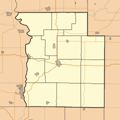
Location of Bloomingdale in Parke County, Indiana.
|
|
| Country | |
| State | |
| County | Parke |
| Township | Penn |
| Area | |
| • Total | 0.58 sq mi (1.51 km2) |
| • Land | 0.58 sq mi (1.51 km2) |
| • Water | 0.00 sq mi (0.00 km2) |
| Elevation | 646 ft (197 m) |
| Population
(2020)
|
|
| • Total | 269 |
| • Density | 462.20/sq mi (178.59/km2) |
| Time zone | UTC-5 (Eastern (EST)) |
| • Summer (DST) | UTC-5 (EST) |
| ZIP code |
47832
|
| Area code | 765 |
| FIPS code | 18-05788 |
| GNIS ID | 2396593 |
Bloomingdale is a small town in Parke County, Indiana, in the United States. It is located within Penn Township. In 2020, about 269 people lived there.
Contents
History of Bloomingdale
The town of Bloomingdale was first planned out in 1825 or 1826. It was originally named Bloomfield. The town was first located a bit south of where it is today.
A post office has been open in Bloomingdale since 1860. An important school called the Friends' Bloomingdale Academy operated here for many years. It was open from 1846 to 1916.
A special historic building, the William Hill Polygonal Barn, was added to the National Register of Historic Places in 1993. This means it is recognized as an important historical site.
On June 17, 2021, a small earthquake happened near Bloomingdale. It was a magnitude 3.8 earthquake. No damage was reported in the town.
Geography of Bloomingdale
Bloomingdale is located about 6 miles (9.7 km) north of Rockville. Rockville is the main town, or county seat, of Parke County. U.S. Route 41, a major highway, passes less than a mile east of Bloomingdale.
According to information from 2010, the town covers a total area of 0.58 square miles (1.5 square kilometers). All of this area is land.
Population and People
| Historical population | |||
|---|---|---|---|
| Census | Pop. | %± | |
| 1880 | 355 | — | |
| 1890 | 431 | 21.4% | |
| 1900 | 505 | 17.2% | |
| 1910 | 528 | 4.6% | |
| 1920 | 479 | −9.3% | |
| 1930 | 412 | −14.0% | |
| 1940 | 432 | 4.9% | |
| 1950 | 434 | 0.5% | |
| 1960 | 455 | 4.8% | |
| 1970 | 391 | −14.1% | |
| 1980 | 409 | 4.6% | |
| 1990 | 341 | −16.6% | |
| 2000 | 319 | −6.5% | |
| 2010 | 335 | 5.0% | |
| 2020 | 269 | −19.7% | |
| U.S. Decennial Census | |||
2010 Census Information
In 2010, there were 335 people living in Bloomingdale. These people lived in 129 households, and 96 of these were families. The town had 150 housing units, which are places where people can live.
Most of the people in the town were White (97.6%). A small number were African American (0.3%) or from two or more races (2.1%). About 0.3% of the population identified as Hispanic or Latino.
Of the 129 households:
- 35.7% had children under 18 living with them.
- 55.8% were married couples living together.
- 14.0% had a female head of household with no husband present.
- 4.7% had a male head of household with no wife present.
- 25.6% were not families.
The average household had 2.60 people. The average family had 3.02 people.
The average age of people in Bloomingdale was 38.5 years old.
- 23.6% of residents were under 18 years old.
- 10.9% were between 18 and 24 years old.
- 22.8% were between 25 and 44 years old.
- 30.2% were between 45 and 64 years old.
- 12.8% were 65 years old or older.
The population was almost evenly split between males and females. About 50.4% were male and 49.6% were female.
See also
 In Spanish: Bloomingdale (Indiana) para niños
 | DeHart Hubbard |
 | Wilma Rudolph |
 | Jesse Owens |
 | Jackie Joyner-Kersee |
 | Major Taylor |


