Vermillion County, Indiana facts for kids
Quick facts for kids
Vermillion County
|
||
|---|---|---|

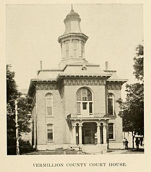
The Vermillion County Courthouse in Newport
|
||
|
||
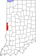
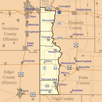
Location within the U.S. state of Indiana
|
||
 Indiana's location within the U.S. |
||
| Country | ||
| State | ||
| Founded | February 1, 1824 | |
| Named for | Vermilion River | |
| Seat | Newport | |
| Largest city | Clinton | |
| Area | ||
| • Total | 259.93 sq mi (673.2 km2) | |
| • Land | 256.88 sq mi (665.3 km2) | |
| • Water | 3.05 sq mi (7.9 km2) 1.17%% | |
| Population
(2020)
|
||
| • Total | 15,439 | |
| • Density | 59.3968/sq mi (22.9332/km2) | |
| Time zone | UTC−5 (Eastern) | |
| • Summer (DST) | UTC−4 (EDT) | |
| Congressional district | 8th | |
| Indiana county number 83 | ||
Vermillion County is a county located in the western part of Indiana, a state in the United States. It sits right between the Illinois border and the Wabash River. In 2020, about 15,439 people lived here. The main town and county seat is Newport.
Vermillion County was officially created in 1824. It was the 50th county formed in Indiana. This area is also part of the larger Terre Haute city area. The county has seven towns, where about 9,900 people live. There are also smaller communities and five areas called townships that help with local services. Major roads and a railroad line run through the county.
Contents
History of Vermillion County
How Vermillion County Was Formed
The first people settled in this area around 1816. This was the same year Indiana became a state. At first, this land was part of Vigo County. Later, in 1821, Parke County was created. Finally, on January 2, 1824, the Indiana government decided to create Vermillion County from Parke County. This change officially happened on February 1, 1824. The town of Newport was chosen as the county seat later that year.
Why the Name "Vermillion"?
The county got its name from the Vermilion River. This river flows nearby and heads south. The name "Vermillion" is spelled with a double "l," like in French or British English. This is different from the neighboring Vermilion County, Illinois, which spells it with one "l." It's quite rare for two counties with the same name to border each other in different states!
Courthouses Through the Years
The first building used for county business was a simple wooden one. It was built in 1824. Then, a brick courthouse was built in 1831. Sadly, this building caught fire in 1844 but was repaired. It was used until 1868 when a third courthouse was built. This one cost $30,000. An extra part was added in 1903 for $28,000.
On May 27, 1923, lightning struck this third courthouse. It was mostly destroyed by fire. Work on the fourth and current courthouse began that same year. It was designed by Halbert Fillinger and John Bayard. This stone building cost $358,707 to build. It was officially opened on June 11, 1925.
The Newport Hill Climb Event
The Newport Hill Climb is a famous event that started in 1909. It's a race where old cars try to drive up a steep hill. The event stopped and started a few times over the years. But now, the Newport Lions Club organizes the Newport Antique Auto Hill Climb. It has been held every year since the 1960s. Hundreds of classic cars participate each time!
Fairgrounds Grandstand Fire
On January 26, 2017, a large fire destroyed the old wooden grandstand at the Vermillion County Fairgrounds. This grandstand was built in 1933 as part of a government work project. It was the oldest wooden grandstand in Indiana. Firefighters from Cayuga said the cause of the fire seemed suspicious.
Geography and Landscape
Where is Vermillion County?
Vermillion County is not very wide, less than 10 miles across at its widest point. But it is quite long, stretching over 37 miles from north to south. To the north, it shares a 6.5-mile border with Warren County. The Wabash River forms its eastern border. Across the river are Fountain and Parke counties. Vermillion County is the southernmost county in Indiana that is entirely on the west side of the Wabash River. Vigo County is to the south.
To the west, Vermillion County borders Illinois. Vermilion County, Illinois is to the northwest. Its main city, Danville, is west of Vermillion County's northern border. To the southwest is Edgar County. Its main city, Paris, is west of Vermillion County's southern border. The state capital, Indianapolis, is about 65 miles to the east.
Land and Water Features
The county covers about 259.93 square miles in total. Most of this (98.83%) is land, and a small part (1.17%) is water. The Vermillion River, which gave the county its name, flows from Illinois into Vermillion County. It then empties into the Wabash River near Cayuga. About 23% of the county is covered by forests. These are mostly deciduous hardwood trees like maple, beech, oak, and hickory.
Townships and Communities
When the county was formed in 1824, four townships were created: Clinton, Helt, Highland, and Vermillion. Later, Eugene Township was formed from parts of Highland and Vermillion.
There are seven towns in Vermillion County:
- Cayuga: Located near where the Vermillion and Wabash rivers meet.
- Clinton: The largest town in the county, with about 5,100 people.
- Fairview Park: Just north of Clinton.
- Dana: A small town located near the intersection of U.S. Route 36 and State Road 71.
- Newport: The county seat, even though it's one of the smallest towns.
- Perrysville: Also located along the Wabash River.
- Universal: In the far southern part of the county.
Many smaller, unincorporated communities also exist. Helt Township has the most, including Alta, Bono, Highland, Hillsdale, Jonestown, Saint Bernice, and Summit Grove. Clinton Township includes Blanford, Centenary, Klondyke, and Syndicate. Highland Township has Flat Iron, Gessie, Rileysburg, and Tree Spring. Eugene Township has just one unincorporated community: Eugene.
Some communities that once existed in Vermillion County are now gone. These include Quaker, Randall, and Toronto.
Climate and Weather
| Weather chart for Newport | |||||||||||||||||||||||||||||||||||||||||||||||
|---|---|---|---|---|---|---|---|---|---|---|---|---|---|---|---|---|---|---|---|---|---|---|---|---|---|---|---|---|---|---|---|---|---|---|---|---|---|---|---|---|---|---|---|---|---|---|---|
| J | F | M | A | M | J | J | A | S | O | N | D | ||||||||||||||||||||||||||||||||||||
|
1.9
32
15
|
1.8
38
20
|
2.8
49
29
|
3.4
62
39
|
4.3
73
50
|
4.5
82
60
|
4.2
85
63
|
3.7
83
60
|
3.1
77
52
|
2.8
65
41
|
3.2
50
33
|
2.5
37
21
|
||||||||||||||||||||||||||||||||||||
| temperatures in °F precipitation totals in inches source: The Weather Channel |
|||||||||||||||||||||||||||||||||||||||||||||||
|
Metric conversion
|
|||||||||||||||||||||||||||||||||||||||||||||||
Vermillion County has a humid continental climate. This means it has cold winters and hot summers. In Newport, average temperatures range from about 15°F in January to 85°F in July. The lowest temperature ever recorded was -26°F in 1994. The highest was 105°F in 1988. The county gets between 1.80 inches of rain in February and 4.53 inches in June.
Transportation Routes
Major Roads and Highways
Interstate 74 crosses the northern part of the county from east to west. U.S. Route 136 also runs through the north, a little further north of I-74. U.S. Route 36 crosses the southern part of the county, passing just south of Dana.
Several state roads also serve the county:
- State Road 32 runs from the state line through Perrysville.
- State Road 63 goes from north to south through the entire county.
- State Road 71 starts near Newport and goes southwest through Dana and Bono.
- State Road 163 runs east through Clinton to connect with U.S. Route 41.
- State Road 234 runs from the Illinois border through Cayuga.
Railroad Lines
CSX Transportation operates a railroad line that runs north to south through Vermillion County. It passes through Rilesyburg, Cayuga, and Clinton. Another CSX line comes from Illinois and meets the north-south line near Hillsdale. The Vermilion Valley Railroad also crosses the very northern edge of the county.
Local Airports
Vermillion County has three small airports:
- The Clinton Airport in Clinton.
- Gessie Airport in Gessie.
- Universal Heli Port in Universal.
The larger Indianapolis International Airport is about 65 miles to the east.
Economy and Jobs
Vermillion County's economy relies on about 7,924 workers. In December 2010, the unemployment rate was 12.5%. Government jobs make up 13% of the county's employment. Manufacturing accounts for 12.4% of jobs, and construction for 10%. About 8.5% of jobs are related to farming.
Largest Employers
Here are some of the largest full-time employers in Vermillion County as of 2017:
| Largest Fulltime Employers of Vermillion County (as of 2017) | ||
|---|---|---|
| Rank | Employer | Number of Employees |
| 1 | White Construction | 577 |
| 2 | Elanco | 460 |
| 3 | South Vermillion School Corp | 285 |
| 4 | Union Hospital | 160 |
| 5 | International Paper | 140 |
| 6 | Duke Energy | 120 |
| 7 | North Vermillion School Corp | 120 |
| 8 | Scott Pet Products | 54 |
| 9 | National Gypsum | 22 |
| 10 | Scott Oil, Inc. | 21 |
| 11 | Hog Slat | 18 |
| 12 | Clinton Color Crafters | 17 |
| 13 | AC Grain | 12 |
Famous People from Vermillion County
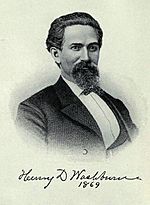
- Henry Dana Washburn (1832–1871): Born in Vermont, he moved to Vermillion County in 1850. He became a lawyer in Newport. During the Civil War, he was a general for the Union side. After the war, he was elected to the United States House of Representatives. In 1870, he led an important trip to explore the area that later became Yellowstone National Park. He passed away in Clinton.
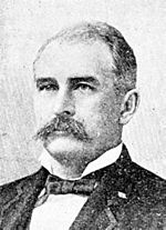
- Claude Matthews (1845–1898): He was the governor of Indiana from 1893 to 1897. Born in Kentucky, he moved to Vermillion County in 1867 and became a successful farmer. He was elected Indiana Secretary of State before becoming governor. He is buried in Clinton.
- Ernie Pyle (1900–1945): Born on a farm near Dana, Ernie Pyle became a famous journalist. He worked for newspapers and was one of the first aviation columnists. He became a war correspondent during World War II. His writings from the war earned him a Pulitzer Prize. He died in combat in 1945.
- Ken Kercheval (1935–2019): Born in Clinton, Ken Kercheval became an actor. He is best known for playing "Cliff Barnes" in the popular TV show Dallas.
- Dana Lewman: She lived in Vermillion County until she was six. She is known for her "Breaking Good" podcast. This series talks about her early life and teenage summers in towns like Dana and Clinton.
Communities in Vermillion County
Townships
- Clinton
- Eugene
- Helt
- Highland
- Vermillion
Cities and Towns
Census-Designated Places
Population Changes Over Time
| Historical population | |||
|---|---|---|---|
| Census | Pop. | %± | |
| 1830 | 5,692 | — | |
| 1840 | 8,274 | 45.4% | |
| 1850 | 8,661 | 4.7% | |
| 1860 | 9,422 | 8.8% | |
| 1870 | 10,840 | 15.0% | |
| 1880 | 12,025 | 10.9% | |
| 1890 | 13,154 | 9.4% | |
| 1900 | 15,252 | 15.9% | |
| 1910 | 18,865 | 23.7% | |
| 1920 | 27,625 | 46.4% | |
| 1930 | 23,238 | −15.9% | |
| 1940 | 21,787 | −6.2% | |
| 1950 | 19,723 | −9.5% | |
| 1960 | 17,683 | −10.3% | |
| 1970 | 16,793 | −5.0% | |
| 1980 | 18,229 | 8.6% | |
| 1990 | 16,773 | −8.0% | |
| 2000 | 16,788 | 0.1% | |
| 2010 | 16,212 | −3.4% | |
| 2020 | 15,439 | −4.8% | |
| 2023 (est.) | 15,417 | −4.9% | |
| U.S. Decennial Census 1790-1960 1900-1990 1990-2000 2010 |
|||
In 2010, there were 16,212 people living in Vermillion County. These people lived in 6,619 households, and 4,533 of these were families. The county had about 63 people per square mile. Most of the people (98.3%) were white. A small number were Asian (0.2%), American Indian (0.2%), or black (0.1%). About 0.8% of the population was of Hispanic or Latino origin.
The average household had 2.42 people, and the average family had 2.90 people. The average age of people in the county was 41.9 years old.
The average income for a household in the county was $47,697. For families, it was $50,743. About 14.7% of the population lived below the poverty line. This included 21.9% of those under 18 and 13.2% of those aged 65 or older.
See also
In Spanish: Condado de Vermillion (Indiana) para niños
 | James Van Der Zee |
 | Alma Thomas |
 | Ellis Wilson |
 | Margaret Taylor-Burroughs |


