Vermilion River (Wabash River tributary) facts for kids
Quick facts for kids Vermilion River |
|
|---|---|

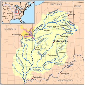
Map of the Vermilion River (including the Salt, Middle, and North forks) highlighted within the Wabash River watershed.
|
|
| Country | United States |
| Physical characteristics | |
| Main source | Confluence of the Middle Fork and Salt Fork west of Danville, Illinois 40°06′13″N 87°43′01″W / 40.1036474°N 87.716968°W |
| River mouth | Wabash River northeast of Cayuga, Indiana 472 ft (144 m) 39°57′31″N 87°26′24″W / 39.9586493°N 87.4400157°W |
| Length | 28.4 miles (45.7 km) |
| Basin features | |
| Progression | Vermilion River → Wabash → Ohio → Mississippi → Gulf of Mexico |
| Tributaries |
|
| GNIS ID | 445248 |
The Vermilion River is a river that flows through parts of Illinois and Indiana in the United States. It's a "tributary," which means it's a smaller river that joins a larger one. The Vermilion River flows into the Wabash River.
It can be a bit confusing because there are actually two rivers named "Vermilion River" in Illinois! The one we're talking about here flows south towards the Wabash River. The other Vermilion River flows north into the Illinois River. There are also two "Little Vermilion Rivers," one that joins the Wabash River and another that flows into the Illinois River.
Interestingly, the north-flowing Vermilion River and the south-flowing Middle Fork Vermilion River (which is part of our Vermilion River) are almost in a straight line. They connect places like Oglesby and Danville. These two rivers helped drain what used to be a big marsh (a type of wetland) near Roberts. People have even dug ditches to make them connect even more closely at their starting points. Early settlers might have thought they were one river that just flowed in two different directions! These rivers might have even been used as a canoe path between the Illinois River and the Wabash River, with people carrying their canoes across the marshy land near Roberts.
Contents
Meet the Tributaries of the Vermilion River
The Vermilion River is formed by several smaller rivers, called tributaries, that join together. The main ones meet near the city of Danville.
- Salt Fork Vermilion River
- Middle Fork Vermilion River
- North Fork Vermilion River
The Vermilion River officially begins where the Salt Fork and Middle Fork rivers meet. About 5 miles (8 km) downstream, the North Fork joins them.
Salt Fork Vermilion River
The Salt Fork is the westernmost of these tributaries. It starts north of Urbana and flows east towards Danville. It got its name because of the salty springs found in its lower parts. When the first settlers arrived, these salty springs were very important for making salt, which was a big business back then.
Middle Fork Vermilion River
The Middle Fork starts near Roberts and flows southeast towards Danville. This river is special because it's the only river in Illinois that is part of the National Wild and Scenic Rivers System. This means it's protected for its beautiful scenery and natural state by the United States National Park Service. This lovely stream flows through Kickapoo State Park near Danville. It's a very popular spot for canoeists in Illinois!
North Fork Vermilion River
The North Fork begins in Indiana, northeast of Hoopeston, Illinois. It flows south and southwest until it reaches Danville.
After all these rivers join near Danville, the main Vermilion River continues flowing until it meets the Wabash River. This meeting point is just east of the border between Illinois and Indiana.
Cities and Counties Along the Vermilion River
Many cities, towns, and villages are located within the area drained by the Vermilion River. This area is called its watershed.
- Champaign, Illinois
- Danville, Illinois
- Homer, Illinois
- Hoopeston, Illinois
- Paxton, Illinois
- Rantoul, Illinois
- St. Joseph, Illinois
- Sidney, Illinois
- Urbana, Illinois
- potomac, illinois
Parts of the following counties are also drained by the Vermilion River:
 | Kyle Baker |
 | Joseph Yoakum |
 | Laura Wheeler Waring |
 | Henry Ossawa Tanner |

