
Iroquois County, Illinois facts for kids
Quick facts for kids
Iroquois County
|
|
|---|---|

|
|

Location within the U.S. state of Illinois
|
|
 Illinois's location within the U.S. |
|
| Country | |
| State | |
| Founded | 1833 |
| Named for | Iroquois River |
| Seat | Watseka |
| Largest city | Watseka |
| Area | |
| • Total | 1,119 sq mi (2,900 km2) |
| • Land | 1,117 sq mi (2,890 km2) |
| • Water | 1.6 sq mi (4 km2) 0.1% |
| Population
(2020)
|
|
| • Total | 27,077 |
| • Estimate
(2023)
|
26,136 |
| • Density | 24.197/sq mi (9.343/km2) |
| Time zone | UTC−6 (Central) |
| • Summer (DST) | UTC−5 (CDT) |
| Congressional district | 2nd |
Iroquois County is a county in the northeast part of Illinois, a state in the United States. In 2020, about 27,077 people lived here.
It's the only county in the U.S. named after the Iroquois people. The main town, or county seat, is Watseka. Iroquois County is right next to the state of Indiana.
Contents
History of Iroquois County
Iroquois County was created on February 26, 1833. It was formed from a part of Vermilion County. The county got its name from the Iroquois River, which was named after the Iroquois people.
The first county seat was the town of Iroquois in 1837. However, no official buildings were built there. Offices were just rented. Later, in 1839, the county seat moved to Middleport, where a courthouse and jail were built.
There was a long disagreement between Middleport and Watseka (also called South Middleport) over which town should be the county seat. Finally, in 1865, it was moved to Watseka. The town of Middleport no longer exists, but there is still a Middleport Township. A new courthouse was built in Watseka in 1866. It cost $28,000 and had a jail in its basement. This building was made bigger in 1881, and a new jail was built nearby in 1893.
-
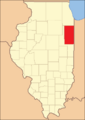
Iroquois County from 1833 to 1836.
-
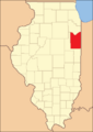
Iroquois County between 1836 and 1853.
-
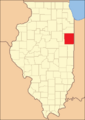
Iroquois County in 1853, after Kankakee County was created.


Geography and Nature
Iroquois County covers about 1,119 square miles. Most of this area, 1,117 square miles, is land, and only a small part (1.6 square miles) is water. It is one of the largest counties in Illinois by land area.
The northern border of the county is about 60 miles south of Chicago. To the east, it borders Indiana and its counties, Benton and Newton. Kankakee County is to the north. Vermilion County, where Iroquois County originally came from, is to the south. To the west is Ford County.
The Iroquois River flows into the county from Indiana. It passes by the village of Iroquois and the city of Watseka. Then, it turns north and joins the Kankakee River near the city of Kankakee. The Kankakee River then flows into the Illinois River. Sugar Creek, another stream, also flows from Indiana through the county. It passes Milford and Woodland before joining the Iroquois River near Watseka.
The Iroquois County State Wildlife Area is a large state park of 2,400 acres in the northeast part of the county. There are also three nature preserves: Bonnie's Prairie, Hooper Branch Savanna, and Loda Cemetery Prairie. These are special places that protect nature.
Climate and Weather
| Weather chart for Watseka, Illinois | |||||||||||||||||||||||||||||||||||||||||||||||
|---|---|---|---|---|---|---|---|---|---|---|---|---|---|---|---|---|---|---|---|---|---|---|---|---|---|---|---|---|---|---|---|---|---|---|---|---|---|---|---|---|---|---|---|---|---|---|---|
| J | F | M | A | M | J | J | A | S | O | N | D | ||||||||||||||||||||||||||||||||||||
|
1.6
30
14
|
1.7
36
18
|
3.4
48
29
|
3.8
60
39
|
4
72
50
|
4.6
82
59
|
4.2
84
63
|
3.7
83
61
|
3.4
77
53
|
2.9
64
41
|
3.3
49
32
|
2.6
36
21
|
||||||||||||||||||||||||||||||||||||
| temperatures in °F precipitation totals in inches source: The Weather Channel |
|||||||||||||||||||||||||||||||||||||||||||||||
|
Metric conversion
|
|||||||||||||||||||||||||||||||||||||||||||||||
In Watseka, the county seat, temperatures usually range from 14°F in January to 84°F in July. The coldest temperature ever recorded was -28°F in January 1999. The hottest was 105°F in August 1988. The county gets the most rain in June, with about 4.62 inches, and the least in January, with about 1.61 inches.
Neighboring Counties
- Kankakee County - north
- Newton County, Indiana - east
- Benton County, Indiana - east
- Vermilion County - south
- Ford County - west
Transportation in Iroquois County
You can get around Iroquois County using SHOW Bus, which has a local bus route in Watseka. For longer trips, Amtrak trains stop at Gilman station on the Illini and Saluki lines.
Interstate 57 runs through the western part of the county. It connects cities like Champaign and Chicago. This highway passes through or near towns like Chebanse, Clifton, Ashkum, Danforth, Gilman, Onarga, Buckley, and Loda.
U.S. Route 24 crosses the county from east to west. It goes through Gilman, Crescent City, Watseka, and Sheldon. Other important roads include:
 Interstate 57
 U.S. Highway 45
 U.S. Highway 52
 Illinois Route 1
 Illinois Route 49
 Illinois Route 54
 Illinois Route 116
Several train lines also cross the county. The Toledo, Peoria and Western Railway runs from east to west through Gilman and Watseka. A Canadian National Railway line runs near Interstate 57. A CSX Transportation line goes from north to south in the eastern part of the county. The Union Pacific line joins it south of Woodland. Even further east, the Kankakee, Beaverville and Southern Railroad operates another north-south line.
People of Iroquois County
| Historical population | |||
|---|---|---|---|
| Census | Pop. | %± | |
| 1840 | 1,695 | — | |
| 1850 | 4,149 | 144.8% | |
| 1860 | 12,325 | 197.1% | |
| 1870 | 25,782 | 109.2% | |
| 1880 | 35,451 | 37.5% | |
| 1890 | 35,167 | −0.8% | |
| 1900 | 38,014 | 8.1% | |
| 1910 | 35,543 | −6.5% | |
| 1920 | 34,841 | −2.0% | |
| 1930 | 32,913 | −5.5% | |
| 1940 | 32,496 | −1.3% | |
| 1950 | 32,348 | −0.5% | |
| 1960 | 33,562 | 3.8% | |
| 1970 | 33,532 | −0.1% | |
| 1980 | 32,976 | −1.7% | |
| 1990 | 30,787 | −6.6% | |
| 2000 | 31,334 | 1.8% | |
| 2010 | 29,718 | −5.2% | |
| 2020 | 27,077 | −8.9% | |
| 2023 (est.) | 26,136 | −12.1% | |
| U.S. Decennial Census 1790-1960 1900-1990 1990-2000 2010-2013 |
|||

In 2010, there were 29,718 people living in Iroquois County. The population density was about 26.6 people per square mile. Most people (94.7%) were white. About 5.3% of the population was of Hispanic or Latino background. Many people had German (36.5%), Irish (14.1%), American (12.2%), or English (10.1%) family roots.
About 30.2% of households had children under 18 living with them. The average age of people in the county was 43.4 years old.
The average yearly income for a household in the county was $47,323. For families, it was $56,541. About 10.0% of the population lived below the poverty line, which means they had very low incomes. This included 14.1% of those under 18.
Towns and Villages

Cities
Villages
Townships
In 1855, people voted to create township governments, which started in 1856. At first, eleven townships were made:
- Ash Grove
- Beaver
- Belmont
- Chebanse
- Concord
- Loda
- Middleport
- Milford
- Onarga
- Papineau
- Stockland
Over the years, more townships were created from these original ones, making a total of twenty-six. Some of the newer townships include:
- Martinton (1857)
- Iroquois (1858)
- Prairie Green (1858)
- Ashkum (1861)
- Douglas (1861)
- Artesia (1864)
- Fountain Creek (1868)
- Lovejoy (1868)
- Sheldon (1868)
- Milks Grove (1872)
- Pigeon Grove (1876)
- Crescent (1877)
- Danforth (1877)
- Ridgeland (1878)
- Beaverville (1916)
Other Small Communities
These are places that are not officially cities or villages:
- Bryce
- Claytonville
- Delrey
- Eastburn
- Effner
- Fountain Creek
- Goodwine
- L'Erable
- La Hogue
- Pittwood
- Stockland
Notable People from Iroquois County
- Fern Andra (born 1893 in Watseka) - A movie actress and director from 1913 to 1930.
- John Moisant (born 1868 in L'Erable) - A pioneer in aviation and an aeronautical engineer.
- John S. Darrough - A soldier who received the Medal of Honor during the American Civil War. He lived in the county from age 14.
- Henry Bacon (born 1866 in Watseka) - A famous architect.
- Rex Everhart (born 1920 in Watseka) - A Broadway actor who was the voice of Maurice in Disney's "Beauty & The Beast."
- Scott Garrelts - A pitcher for the San Francisco Giants. He grew up in Buckley and was a first-round draft pick in 1979.
- Ray A. Laird (born 1907 in Milford) - President of Laredo Community College in Laredo, Texas, from 1960 to 1974.
- Ole Rynning (1809–1838) - A Norwegian immigrant author.
- Fred J. Schraeder (1923-2016) (born in Clifton) - An Illinois state representative and businessman.
See also
 In Spanish: Condado de Iroquois para niños
