
Ford County, Illinois facts for kids
Quick facts for kids
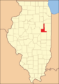
Ford County
|
|
|---|---|

Ford County Courthouse in Paxton
|
|

Location within the U.S. state of Illinois
|
|
 Illinois's location within the U.S. |
|
| Country | |
| State | |
| Founded | February 17, 1859 |
| Named for | Thomas Ford |
| Seat | Paxton |
| Largest city | Paxton |
| Area | |
| • Total | 486 sq mi (1,260 km2) |
| • Land | 486 sq mi (1,260 km2) |
| • Water | 0.6 sq mi (2 km2) 0.1% |
| Population
(2020)
|
|
| • Total | 13,534 |
| • Estimate
(2023)
|
13,250 |
| • Density | 27.848/sq mi (10.752/km2) |
| Time zone | UTC−6 (Central) |
| • Summer (DST) | UTC−5 (CDT) |
| Congressional districts | 2nd, 16th |
Ford County is a county located in the state of Illinois in the United States. In 2020, about 13,534 people lived there. The main town, or county seat, is Paxton. Ford County was once part of the Champaign-Urbana area, but it is no longer included.
Contents
History of Ford County
Ford County was created on February 17, 1859. This makes it the newest county in Illinois. It was formed because some people in Vermilion County felt they lived too far from their county seat. They asked the Illinois General Assembly to create a new county.
Ford County is named after Thomas Ford. He was the Governor of Illinois from 1842 to 1846.
-
The creation of Douglas and Ford Counties in 1859 resulted in Illinois's current county map.

Geography of Ford County
Ford County has a total area of 486 square miles. Almost all of this area is land. Only a tiny part, about 0.6 square miles, is water.
Climate and Weather in Ford County
| Weather chart for Paxton, Illinois | |||||||||||||||||||||||||||||||||||||||||||||||
|---|---|---|---|---|---|---|---|---|---|---|---|---|---|---|---|---|---|---|---|---|---|---|---|---|---|---|---|---|---|---|---|---|---|---|---|---|---|---|---|---|---|---|---|---|---|---|---|
| J | F | M | A | M | J | J | A | S | O | N | D | ||||||||||||||||||||||||||||||||||||
|
1.7
30
14
|
1.4
35
19
|
3.2
48
29
|
3.4
61
39
|
4.4
72
50
|
3.5
82
59
|
3.8
85
62
|
3.3
83
60
|
3.2
77
53
|
3.3
65
41
|
3
49
31
|
3
35
20
|
||||||||||||||||||||||||||||||||||||
| temperatures in °F precipitation totals in inches source: The Weather Channel |
|||||||||||||||||||||||||||||||||||||||||||||||
|
Metric conversion
|
|||||||||||||||||||||||||||||||||||||||||||||||
In Paxton, the county seat, average temperatures change throughout the year. In January, the average low is 14°F. In July, the average high is 85°F. The coldest temperature ever recorded was -25°F in January 1999. The hottest was 102°F in June 1988.
The amount of rain and snow also varies. February usually has the least precipitation, with about 1.40 inches. May typically has the most, with about 4.38 inches.
Counties Near Ford County
Ford County shares borders with several other counties:
- Kankakee County to the north
- Iroquois County to the east
- Vermilion County to the southeast
- Champaign County to the south
- McLean County to the southwest
- Livingston County to the west
Transportation in Ford County
- SHOW Bus provides local transit services.
Major Roads in Ford County
 Interstate 57
 US Route 24
 US Route 45
 Illinois Route 9
 Illinois Route 47
 Illinois Route 54
 Illinois Route 115
 Illinois Route 116
Population of Ford County
| Historical population | |||
|---|---|---|---|
| Census | Pop. | %± | |
| 1860 | 1,979 | — | |
| 1870 | 9,103 | 360.0% | |
| 1880 | 15,099 | 65.9% | |
| 1890 | 17,035 | 12.8% | |
| 1900 | 18,359 | 7.8% | |
| 1910 | 17,096 | −6.9% | |
| 1920 | 16,466 | −3.7% | |
| 1930 | 15,489 | −5.9% | |
| 1940 | 15,007 | −3.1% | |
| 1950 | 15,901 | 6.0% | |
| 1960 | 16,606 | 4.4% | |
| 1970 | 16,382 | −1.3% | |
| 1980 | 15,265 | −6.8% | |
| 1990 | 14,275 | −6.5% | |
| 2000 | 14,241 | −0.2% | |
| 2010 | 14,081 | −1.1% | |
| 2020 | 13,534 | −3.9% | |
| 2023 (est.) | 13,250 | −5.9% | |
| US Decennial Census 1790-1960 1900-1990 1990-2000 2010 |
|||
In 2010, there were 14,081 people living in Ford County. There were 5,676 households, which are groups of people living together. The population density was about 29 people per square mile.
Most people in the county are white (97.1%). A smaller number are black or African American (0.6%), Asian (0.3%), or American Indian (0.2%). About 2.1% of the population were of Hispanic or Latino background. Many residents have German, Irish, American, or English ancestry.
About 30.6% of households had children under 18 living with them. The average age of people in the county was 42.4 years old.
Communities in Ford County

Ford County has several cities, villages, and smaller communities.
Cities in Ford County
Villages in Ford County
Unincorporated Communities in Ford County
These are smaller communities that are not officially organized as cities or villages.
Townships in Ford County
Townships are smaller local government areas within the county.
- Brenton
- Button
- Dix
- Drummer
- Lyman
- Mona
- Patton
- Peach Orchard
- Pella
- Rogers
- Sullivant
- Wall
Images for kids
-
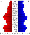
This chart shows the age groups of people in Ford County based on the 2000 census.

See also
 In Spanish: Condado de Ford (Illinois) para niños
